Apostle Islands

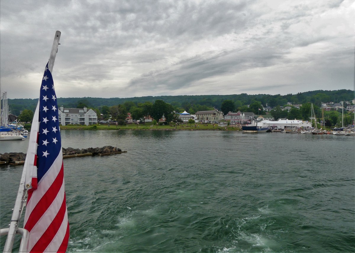
We arrived at Bayfield Harbor for a sunset cruise across Apostle Islands National Lakeshore.

Bayfield harbor

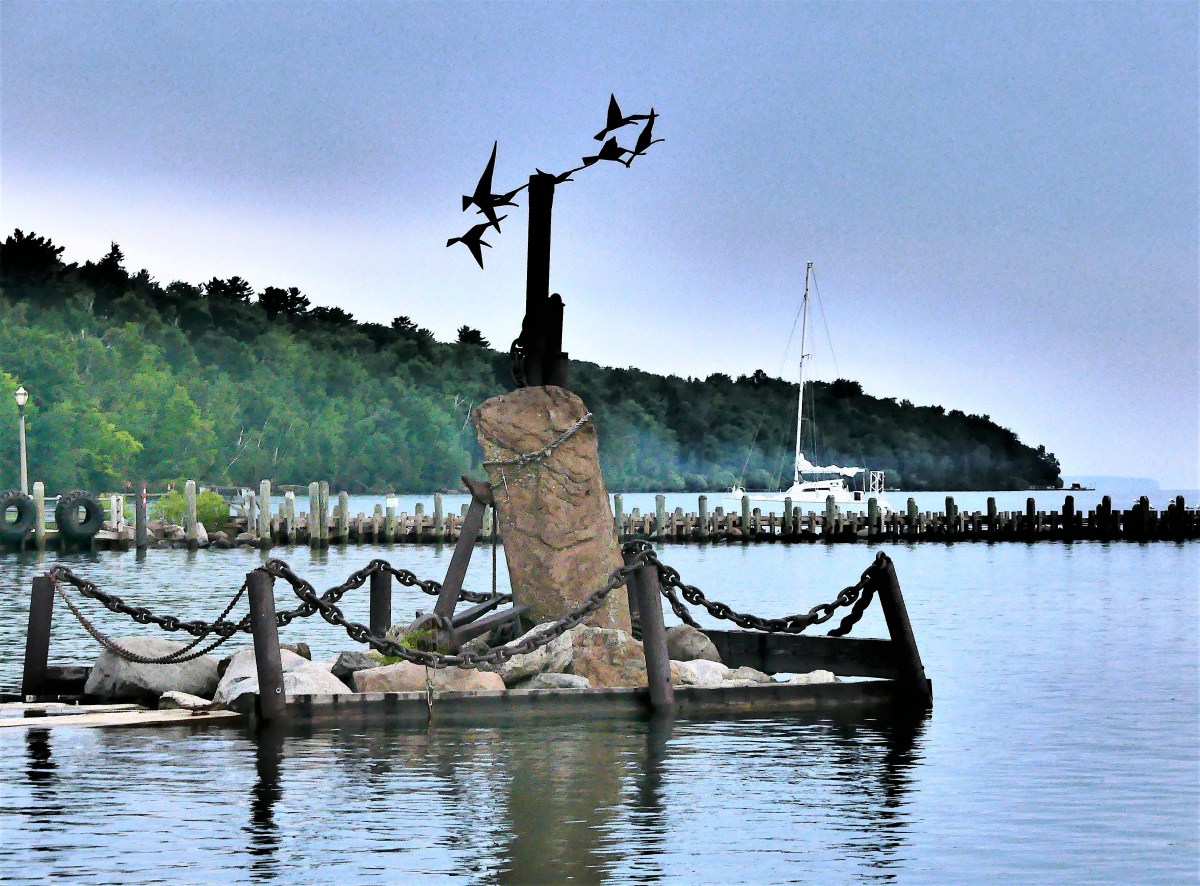
The skies were flat with soft, diffused light, virtually eliminating all late afternoon shadows.

Island Queen

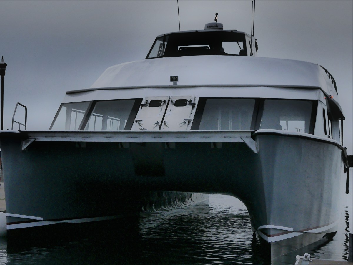
I had my doubts about a sunset, but at least the water was calm. We boarded the Archipelago, Apostle Island Cruises’ newest vessel–a 65-foot, 150-passenger catamaran,

Archipelago1

and soon got underway on our 2½ hour-cruise.

motoring aboard Archipelago

There are 22 Apostle Islands grouped within the archipelago,

map

and according to Captain Mike, we would be running by half of them on the way to Devils Island, the furthest outpost and the geological jewel of the Apostle Islands archipelago.

Just starting out, we passed Basswood Island, the site of Bass Island Brownstone Company Quarry, operational from 1868 to 1893. The bulk of the cut stone was shipped across the Great Lakes, destined for Chicago residences, but the stone stacked by the shoreline never made it off the island. It’s a reminder of a time when buildings seldom exceeded seven stories. 

Basswood Island brownstone

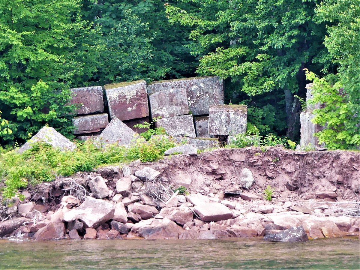
The quarry company went bankrupt after demand for brownstone was replaced by concrete and steel.

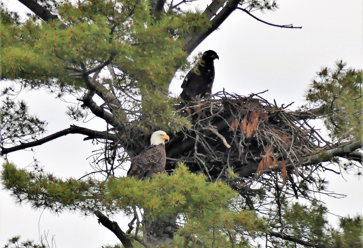
Continuing along, a pair of eagles nesting high in the pines was an unexpected thrill. Last year, 20 eagles were counted within park territory. This year the count has risen to 42.

eagles and nest (4)

Before leaving Basswood Island, Honeymoon Rock figured prominently off the northeast shore.

rockstack

One of the greatest concentrations of black bears in North America is found on Stockton Island. Sadly, we found only trees and a rocky shoal.

Stockton Island

When passing Manitou Island, we were lectured by Captain Mike about several of the fishing camps that originated in the late 1800’s.

Cabins and sheds are still standing at the southwest corner of the island.

sand island smokehouse

After cruising through the channel for a half-hour, we arrived at Devils Island, the northernmost point of land in Wisconsin, and notable for the sea caves which undercut the shoreline.


Devils Island

We idled twelve feet from the rock formations for a closer look at the honeycombing…

sandstone layers

mask

leg in the water

grotto

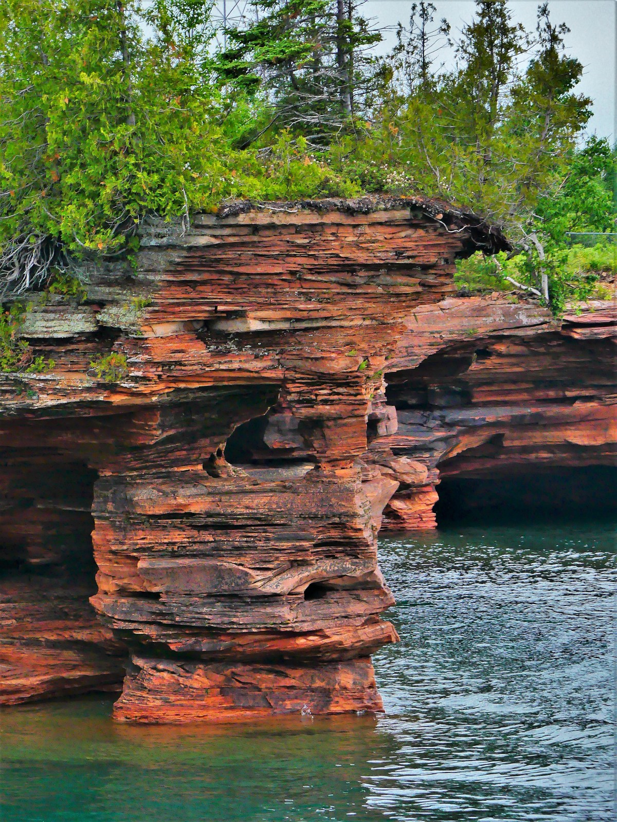
While the overcast skies precluded any possibility of brightening the scenery, the balanced light offered views into the caves that otherwise would have been defeated by sunlight and resultant higher contrast.

cave column

caves and lighthouse

caves on the coast

Captain Mike promised one last photo opportunity before returning the Archipelago to Bayfield Harbor. He was referring to Raspberry Island’s lighthouse, once known as the Showplace of the Apostle Islands.

Raspberry Island lighthouse

As we trolled along the stone wall, we were greeted by the lightkeeper.

lightkeeper (2)

The National Park Service completed renovations of the 1906 structure in 2006.

Raspberry Island lighthouse (2)

On the return trip, Captain Mike asked passengers if they knew the origin story of Apostle Islands’ name. A few volunteers tossed out some theories. One guest suggested that there was something religious about the naming. Another guest offered that the area was first mapped by the Jesuits, so that explains why they gave it a holy name.

I thought the insight was interesting but unreliable, since there were 12 Apostles, for 22 islands. Could it be that the Jesuits had been drinking too much Lake Superior moonshine and seeing double?

Nobody knows!

But photographing Devil’s Island sea caves was a fleeting, yet near-religious experience… with ironic overtones.


Sunset over Agawa Bay

When the sun’s last rays warm Agawa Bay,

sun over the hill

the bugs attack without delay.

Agawa Bay

They make their way, prepared to stay

breaking at sunset

on a patch of skin, where they can win

lake and sky

to my chagrin, a forearm or a shin.

Stones and surf

Mosquitoes take top billing, and black flies are willing

colored pines

to make a killing from their drilling.

trees and sky

But I remain to snap a frame, and find it’s still fulfilling.


Thunder Mountain

From a distance, Mt McKay is imposing, rising 1200 ft over Lake Superior and making it the largest of the Nor’Wester mountains. It gets its name from William Mackay, a Scottish fur trader from the mid-1800s, who lived for a time in the Fort William vicinity.

However, the Fort William First Nation, descendents of the Chippewa tribe, call the mountain Anemki Wajiw (ah-NIM-ih-key waw-JOO), meaning Thunder Mountain,

Thunder Mountain

and consider it sacred land.

In Honor of Our Ojibwa Elders

Mt McKay is a prominent landmark of the Fort Williams First Nation reserve, and offers sweeping views of Thunder Bay…

plane landing

from its boardwalk overlook on the eastern plateau…

boardwalk to overlook (2)

and beyond…

Fort William First Nation

Leah and I drove up Mission Road to a toll house, where a First Nation member collected $5.00. She advised us to hike the western trail to the flat cap for more commanding views, and encouraged us to return in 3 days to witness a powwow of the Lake Superior chapters. She also offered a menu and invited us to visit her lunch counter in town.

The trail was narrow, steep and challenging with shards of shale scattered over rocky formations. We took our time.

After a weary climb of 40 minutes, we welcomed the cooler air around us as we crossed onto a plate of volcanic rock formed over 1,100 million years ago.

Leah and me

The bright sun promised a crisp and dazzling vista,

Thunder Bay overlook

but it also seemed to energize the horse flies that soon regarded me as bait.

harbor view

That’s when I knew it was time to retreat to the bottom of the hill, oh-so-gingerly over long drops onto loose shale.

Once we landed at the trail head, I had decided (after checking with Leah) that we should attend the powwow on Satuday.


On the day of the powwow, we looked for news on the internet. and it was everywhere. The council was expecting over 5,000 attendees over two days with plenty of drumming and dancing. Food tents and crafts stalls would round out the affair. The rules were simple: No Alcohol. No Drugs. No hiking. Have a Safe Time.

We drove to Fort Williams First Nation ice arena, where we met a yellow school bus that shuttled us the rest of the way. Only three days ago, the area was empty and quiet, but today, it looked like a parking lot next to a fairground with fringe tents and trailer camping.

Participants were gathering inside the spirit circle and adjusting their costumes, while spectators were filling the grandstands, and the royalty was assembling in anticipation of the welcoming ceremony.

Welcome ceremony

It was a colorful and festive affair. A steady drum beat managed by eight drummers, accompanied a caterwauling chant of guttural highs and lows and occasional shrieks.

drum circle

After a prolonged opening procession and invocation, Chiefs and Elders presented flags,

Chiefs

and then it was time to drum and sing and dance again. Grass dancers followed Elders…

grass dancers

who were followed by family members…

procession

who also danced several times around the pavillion with their children…

father and son

tiny dancer

showing off their feathers,

eagle feathers

their elaborate ceremonial costumes…

teal man

red costume

blue costume

and their elaborate moves…

Little Bear 2

Little Bear

Little Bear 1

After a couple of hours, Leah and I returned to the boardwalk for a stroll to the memorial,

WW1 Indian memorial

where we discovered a trail to the right that hugged the cliff around the plateau. We hiked further along, scouting for poison ivy as we walked, and came to a clearing where three girls in training bras were sneaking cigarettes around a slab of concrete.

It was an amusing irony and signaled our time to return to the ice arena. The school bus that brought us circled the field–collecting passengers–and momentarily paused at a graphic display of Ojibwe insight and life lessons:

Ojibwe Code

They are good words to live by!

Neys Provincial Park

Dear Diary,

Today was unsettling, as nothing went as planned.

A high probability of intermittent rain had been forecasted throughout the day, which gave us very few options. Although we were snug in our pull-through campsite overlooking the northern boundary of Lake Superior from Neys Provincial Park in Ontario, Canada, we were looking forward to exploring the stark coastal beauty of an area once known from 1941 to 1946 as Neys Camp 100–an internment facility for German POWs and Japanese Canadians.

detention sign

Prisoners arriving (2)
Kreigsmarine and Luftwaffe prisoners of war arriving at Neys, ca. 1941

Prevailing wind from the west had whipped up whitecaps across the water, and threatening skies promised to restrict our outdoor time, but we were determined to make the most of current conditions: buggy, chilly, yet dry.

Terrace Bay

A short walk to the Visitor’s Centre for sight-seeing suggestions proved useless since the door was locked–maybe from campground inactivity, I surmised. There was, however, an interesting park bench design overlooking the lake by Sean Randell. 

Trout bench Neys PP

With 144 sites covering 4 areas, Leah and I spotted less than a dozen occupied sites. Many of the seasonal campers left their trailer set-ups behind for greater comforts nearby. With electricity only provided at less than half the sites, we had the showers practically to ourselves.

We were determined to get a hike in, so we selected the 1 km Dune Trail loop for its brevity (in case of sudden rain), and our fascination with sand dunes by the lake. We followed each other single file through a skinny path snaking through a plantation of red pines and a forest floor of lichens, mosses, and herbs. But we never found the dunes–only rolling mounds of sand over soil. We began the hike with an interpretive trail guide corresponding to 7 markers, but mosquitoes quickly put an end to that. We found ourselves marching through the forest just to complete the loop. The roundtrip walk to the trailhead proved to be longer than the entire trail.

With a faint drizzle falling, we planned a 35-mile drive to Terrace Bay, following TransCanada Highway 17 west around the top of Lake Superior, but the truck refused to start. Earlier in the week, I was stuck in a parking lot under similar circumstances, but Leah located a Samaritan willing to give me a battery boost. Today, however, was a different mater. After shlepping a spare battery around America for tens of thousands of miles, I finally got a chance to use it.

The battery installation set us back half an hour. And then the sky opened up the moment I dropped the hood and climbed inside the cab. It was an auspicious moment in my life!

We finally arrived at Terrace Bay (pop. 1100) and descended an elaborate boardwalk to a high viewing platform that distanced us from Aquasabon Fall’s 100-ft. drop,

Aquasabon Falls

and the granite gorge that carries the spill water to Lake Superior.

Aquasabon Falls and Gorge

Back at the boardwalk entrance, I stood alongside a millennial male. We were studying an oversized graphic together about the geological properties and commercial significance of the Falls.

Falls and Gorge graphic

My neighbor had a cat perched on his shoulder wearing a harness with a leash. Suddenly, a light rain began to fall, spooking the cat. It leapt to the ground, surprising the host. He had control for a moment, but it squirmed out of his arms, and wriggled free of its harness. He dove for the hind legs, but the cat was too fast. It bolted 50 yards to the trees, and disappeared in the brush with his girlfriend chasing after it and screaming its name. We briefly watched in amusement, wondering if the cat would reconnect with its owners, but we had our doubts.

While in town, we filled the truck with $130 Canadian of gas, and searched for a lunch spot, but ended up at a Chinese Canadian restaurant in a strip mall just to use the internet. I had fried chicken balls (no joke), and Leah ordered dry-rubbed spare ribs. The food was as disappointing as a dead car battery and tasteless as a lost cat in the woods.

spare ribs

A stubby white lighthouse planted in front of the strip mall parking lot offered a view of Lake Superior. To Leah’s amazement, I passed on a picture of the tower and a view from the bridge. 

The ride back to Neys was rainswept and uninteresting except for a cow moose that galloped across TransCanada Highway 17, followed closely by two calves. They hurdled the guard rail and instantly disappeared into the forest. Maybe they’ll discover the cat.