Hiking a Shrinking Glacier

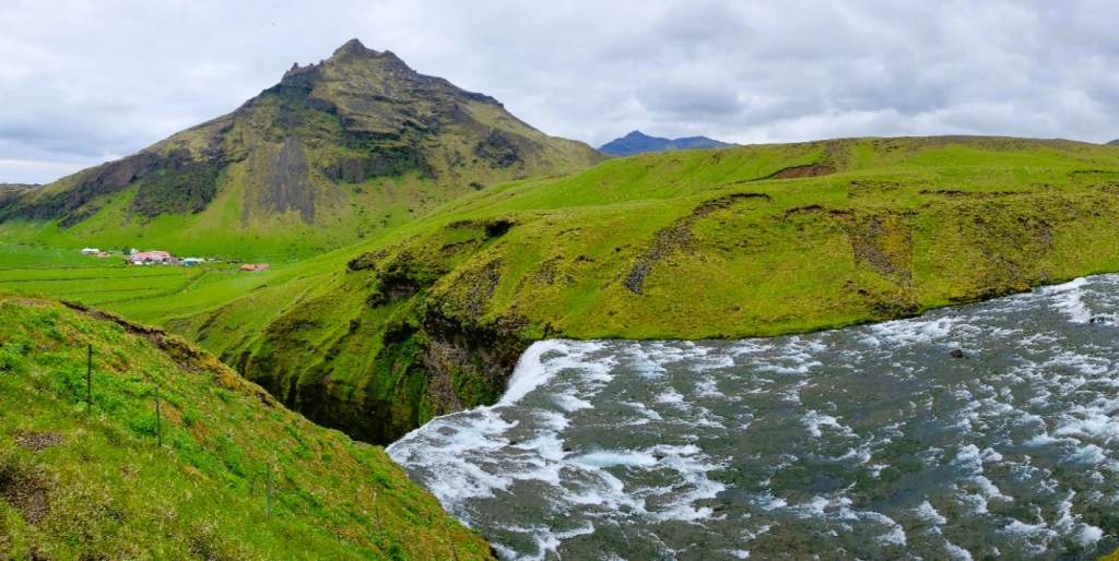
There is a glacier lagoon at the tip of Sólheimajökull’s tongue that never existed a decade ago. Today, that lagoon is 80 meters deep, and its fed by glacial melt.

Sólheimajökull is an 11km outlet glacier of Mýrdalsjökull, Iceland’s 4th largest ice cap of 269 named glaciers, and easily accessible and suitable for ice adventuring.

Climatologists have been studying Sólheimajökull’s since 1930, documenting a loss of more than 2 sq.km. of its ablation area, and retreating a mile from its original marker.

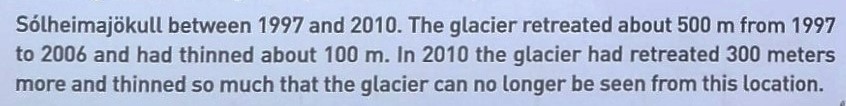
During the summer Sólheimajökull loses 3 meters of ice every month with frequent ice calving.

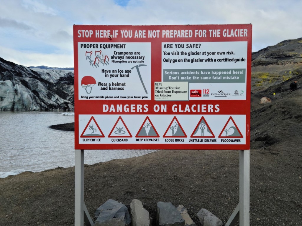
With so much chatter about climate change and glacier volatility, I thought it best to have a look around the ice and judge for myself. So Leah and I drove to Sólheimajökull to join a guided glacier expedition,

where we were outfitted with a harness, helmet, crampons and ice pick. With some instruction, we learned how to dress ourselves and behave like mountaineers.

Then the conversation shifted to safety first, and how to avoid the treacherous crevasses on a melting ice mountain that’s constantly in motion.

After a brief hike, we arrived at the ice, but the approach to the top wasn’t a graduated trail; it was a wall.

Suddenly, I felt our training was insufficient, and I couldn’t imagine that all of us were prepared to dig in with our crampons and ice axes and climb over this wall, but that was unnecessary. We simply stepped around the mound on chiseled risers that were rapidly melting…

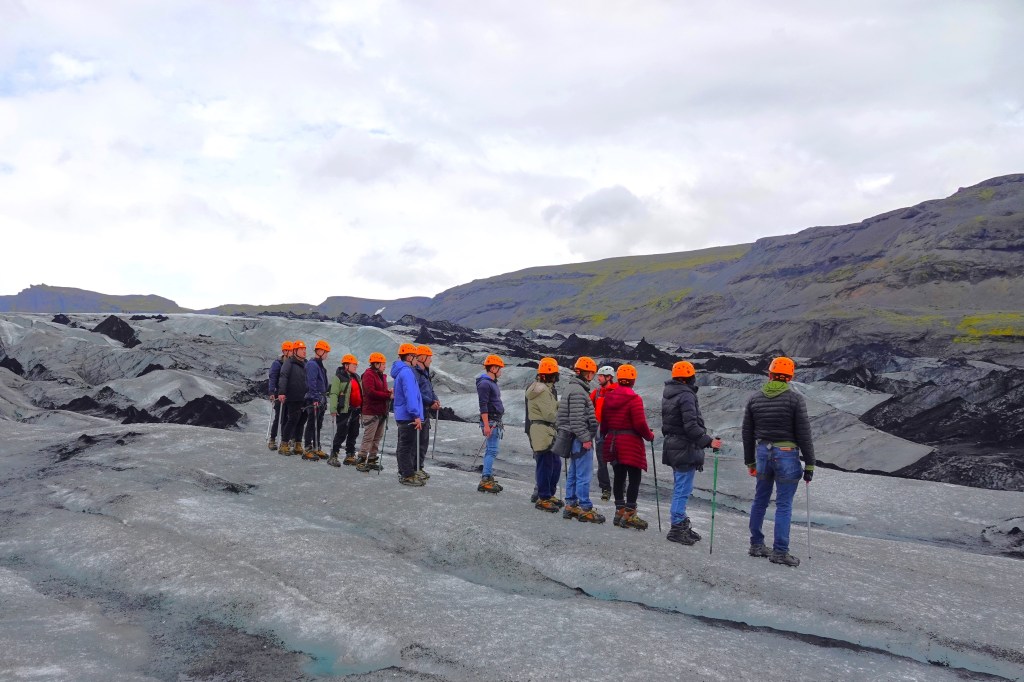
until we all reached flat ice.

I questioned why this ice had a different color and texture–more like ice coal–than blue crystal.

Valerio, our guide from northern Italy attributed it to the 1918 eruption of Katla, Iceland’s largest active volcano, and fragments of rock and debris–known as glacial till–that typically develop when a glacier passes over bedrock. We were walking on 100-year ice dated by the volcanic ash trapped inside the ice!

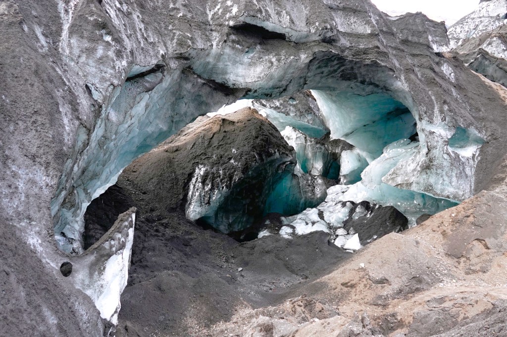
Except for occasional photo ops like a discovered ice cave,

we were always moving across the ice and up the throat, and discouraged from breaking the line or falling behind.

After 30 minutes on the ice, it was time to celebrate with a drink. Valerio grabbed his New Zealand ice ax to tap a vein under the ice, and the bar was open…

and it was cold and refreshing!

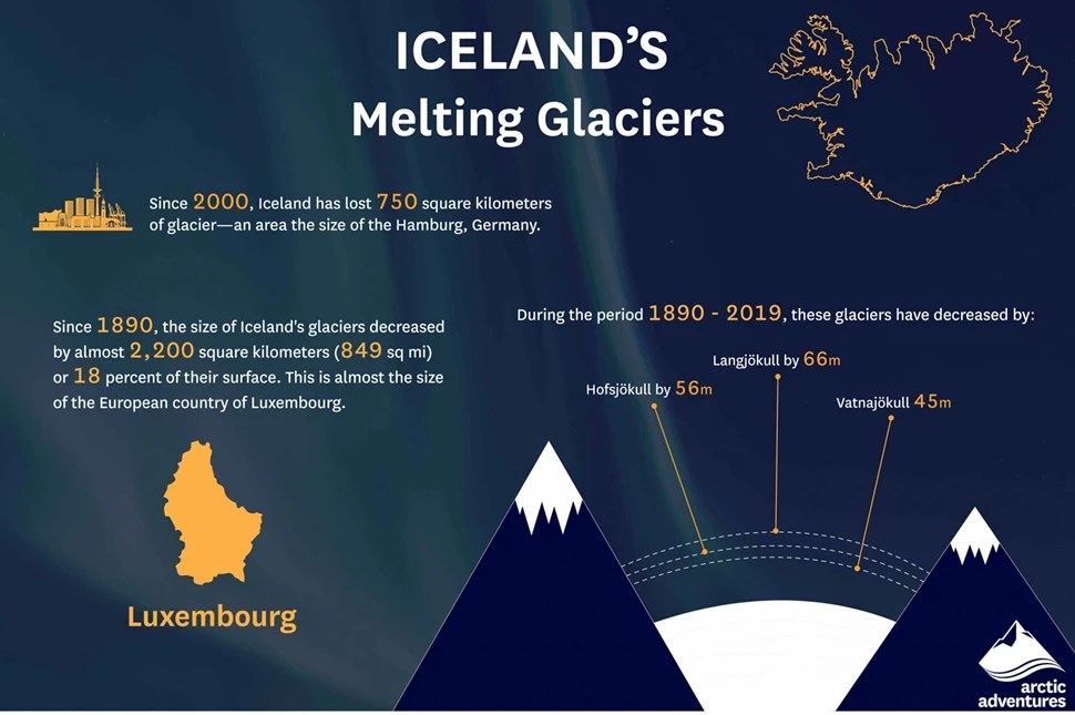
Since 1890, Iceland has lost approximately 18% of its ice mass to warming, and Sólheimajökull is melting faster than scientists originally speculated. They are sounding the alarm–telling us that Iceland’s glaciers are melting faster than they can recover.

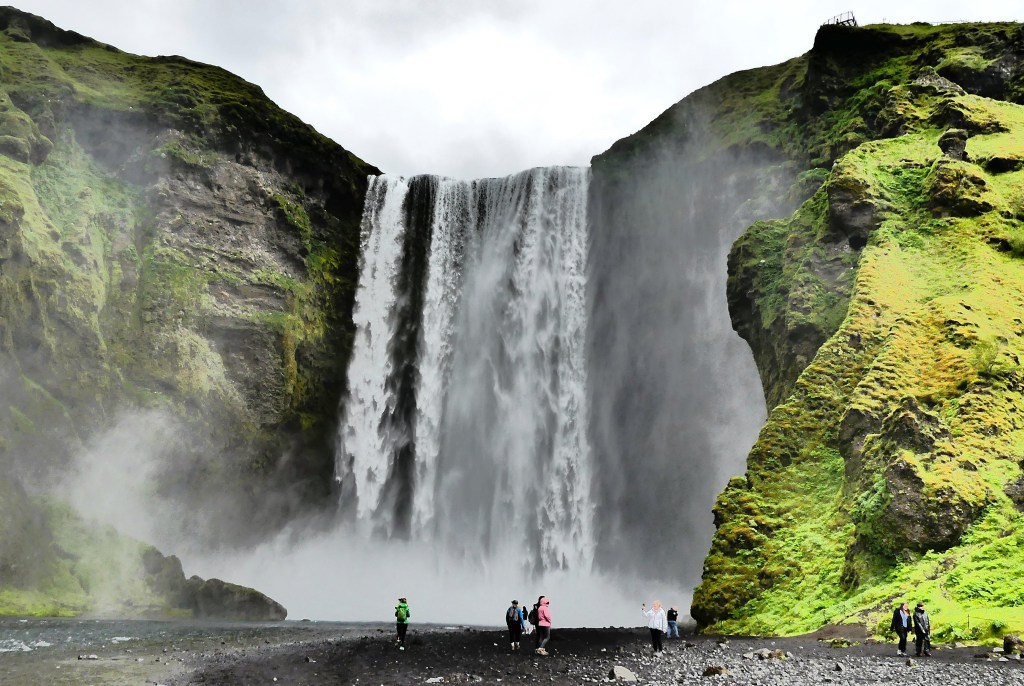
And climate change, of course, plays a pivotal role in this process. Ironically, eco-tourists are rushing to Iceland to experience the glaciers before they disappear.

But Iceland is doing something to mitigate the damage by pledging carbon-neutrality before 2040. Already, the island’s geography and geology provide almost 100% renewable energy for generating heat and electricity.

But will it be enough for future generations?…

Seljalandfoss and Skógafoss

There is no shortage of waterfalls in Iceland, although some are more spectacular than others. Estimates of total waterfalls throughout range from 10,000 and up. But Icelanders have their favorites, and Seljalandfoss and Skógafoss are two of them. Located just off the Golden Circle and only 30K apart made it impossible to resist, so off we went, chasing waterfalls.

What makes Seljalandfoss special is its geological standing. It’s believed to be a part of Iceland’s receding coastline in Southern Iceland, where the Seljalandsá River once ran over the edge of a volcanic cliff and dropped into the Atlantic. 

Seljalandsfoss’ glacial water originates from the Eyjafjallajökull glacier, a smallish ice cap atop Eyjafjallajökull volcano that last erupted spontaneously in 2010, belching so much ash high into the atmosphere that day turned into night and European air traffic was grounded for 5 days.

Eyjafjallajökull towers above the waterfall,

and the Eyjafjöll mountains feed meltwater to the river Seljalandsá, which runs down the slopes before dropping off the Seljalandsheiði heath in the form of Seljalandsfoss waterfall.

Repeated eruptions over millennia have extended the coastline by 12K, while erosion has hollowed out an extraordinary hiking trail that circles behind Seljalandfoss, which literally translates to “selling the land of waterfalls.”

Leah and I could immediately tell upon approach that this was a popular destination, which was soon confirmed by a full parking lot. There was a kiosk for paying the 800 ISK parking fee ($6), but I didn’t realize it until we were leaving. Oh well, I guess I was too focused on the shower I was about to take.

But Leah had different plans. “I’m not doing that,” she insisted. “I can’t find my rain pants anywhere and there’s no way I’m getting soaked. Besides, it’s probably slick from all the mud and water, and I don’t feel like breaking my neck on the third day of vacation. But you should go, and I’ll just look at the pictures later….Tell me about your insurance, again.”

“Shouldn’t we at least take a selfie like everyone around us?” I asked.

Leah had decided that Seljalandfoss’ 60 meter (200 feet) cascade was best appreciated from a distance,

while I was too anxious to capture Seljalandfoss from every angle.

True, the trail was muddy and slippery, but that was only a minor inconvenience.

The challenge came from dodging the unrelenting spray, as if it was weaponized by the wind.

I instantly missed Leah as my assistant. She would have made the perfect rain shield.

After coming around the back side of Seljalandross, I rejoined Leah on a path which led to a small waterfall known as Gljufrabui,

hidden within a slotted canyon.

We hiked back to the Land Cruiser and headed in the direction of Holt. I was casually driving, enjoying the scenery at 90 kph (60 mph), Iceland’s top speed limit, when I hit the brakes….after noticing Iceland’s perfect farm.

We made one additional stop along the way to Skogafoss, when I slowed to catch a glimpse of what appeared to be a Hobbit house built into the mountain.

However, on closer examination, it appeared to be a shelter for sheep and goats.

The approach to Skogafoss had several imposing mountains in the vicinity, also part of the former coastline.

Ironically, Skógafoss translates into Forest Falls, but there’s not a tree to be found in the area. It seems the Vikings had a penchant for chopping all of them down to create their settlement a thousand years ago.

Skógafoss is one of the biggest waterfalls in Iceland. Game of Thrones fans may recognize the falls as the aerial backdrop for a romantic encounter between Daenerys Targaryen and Jon Snow when flying with her dragons.

With a width of 25 m (82 ft) and dropping 60 m (200 ft) with water fed by two glaciers, a rarity (Eyjafjallajökull and Mýrdalsjökull),

visitors can climb a rickety 430-step metal staircase anchored into the cliff, allowing visitors to reach the spillover and enjoy a view of the coastal lowlands while basking in the Highlands, or continue on a popular trail leading up to the pass between both glaciers.

Skógafoss is a place where magic happens…

Completing the Golden Circle

Feeling exhilarated after our Silfra snorkeling adventure, Leah and I said goodbye to Thingvellir, and set out to complete the remaining natural wonders of the Golden Circle trifecta.

We continued to Haukadalur, a geothermal valley in South Iceland that boasts a plethora of fumaroles and geysers,

including the powerful and predictable Strokkur, Iceland’s most active geyser that regularly erupts every 5 to 10 minutes like clockwork,

sending boiling water skyward, 20 to 40 metres beyond its mineral-stained crust.

Afterwards, we traveled to Hvítá river canyon to visit Iceland’s beloved falls, Gullfoss. The water in Hvítá river travels from the glacier Langjökull, Iceland’s second largest ice cap, before cascading 32 meters (105 feet) down Gullfoss’ double drops in dramatic display.

We arrived in time for one of Iceland’s typical daily weather changes as we hiked to the closest observation deck. The blustery gales had driven the cold drizzle and falls spray sideways. While we were dressed appropriately in warm parkas and rain pants, Leah was miserable and could only manage a walk to one of many overlooks of Gullfoss.

I tried to ignore the weather, but the poor visibility and annoying spritz was affecting my ability to keep the camera lens dry while trying to capture the “perfect shot.”

Leah retired to the comfort of the Land Cruiser, while I climbed above the canyon wall in search of a different perspective, thinking that if I distanced myself from the water, I could keep my camera dry.

The best that I could manage, given the circumstances was adequate…

However, to my chagrin, I found the perfect shot at the base of the foothills, but it belonged to a park graphic with information about Gullfoss…

However, looking southeast, I also discovered a telling view of Thingvellir’s distant topography just beyond the Visitor Center.

Of course, being a national park, certain rules apply; and understandably, drone photography is a no no. But Gullfoss is so expansive that it would surely benefit from an aerial approach, so the Park Service sanctioned a third party to capture the awe and splendor that only a drone can see.

We ended our day in Selfoss,

where more adventures await…

Touching North America from Eurasia

There is one place on earth–Silfra–where it’s possible to “touch” two different continents underwater and it’s located within the Golden Circle of Iceland. Leah and I were up for the challenge, but it required some preparation.

First, we traveled southeast of Reykjavik to Thingvellir National Park, the birthplace of parliamentary government (Althing, 930 AD), and the zone where volcanic activity has played a heavy hand in shaping our planet.

Not to get too bogged down in earth science, but a rift occurred through the middle of Iceland where two tectonic plates are pulling away from each other 2.5 centimeters every year as a result of volcanic activity in the region since the beginning of time,

and much of it vents under Lake Thingvallavatn, Iceland’s largest lake.

Above sea-level, lava fields at Thingvellir have been torn apart by tectonic forces, leaving gorges and fissures to admire between two continents.

However, inside the rift valley created by daily earthquakes throughout time, there is one ravine, Silfra that allows snorkelers and divers to experience the tectonic plates underwater, but it requires a dry suit to tolerate the water temperature (2o C) and a certified outfitter to guide thru the underwater fissure.

Leah and I had booked an excursion through Arctic Adventures, who supplied all of our underwater gear and a guide to assist with dressing, and underwater photography.

We dressed in a parking lot by the roadside where various outfitters have set up shop.

Over the thermals and wool socks we supplied, we stepped into fully insulated jumpsuits to wear under incredibly bulky dry suits with fixed booties, snug rubber sleeve guards around our wrists, lashed with rubber bands, and a snug rubber seal around our neck with a rubber band choker. An industrial zipper across our deltoids sealed us in.

Then came a rubberized neoprene hood over our heads. Imagine forcing your head through your neck. After accessorizing our fashionable outfits with neoprene lobster gloves, we were ready for the apocalypse.

We were a group of twelve…

under the supervision of Chris (from Hungary) and Marcelo (from Sao Paulo). We split into 2 groups of 6,

and waited our turn to enter the water.

Immediately, the suit constricted around my lower body as I stepped deeper and deeper into frigid water…but I stayed dry! Without hesitation, I glided in and immersed my face. Only the small area around my facemask was exposed and the sensation around my lips felt like a cold scalding until they turned numb after 10 seconds.

We flopped onto our backs, and let the current carry us slowly through the gorge while watching the arctic terns doing aerial maneuvers overhead.

As we floated past Grynningar Shallows, I was awed by the clarity of the water, with visibility beyond 100 meters (300 ft).

We were in the water approximately 40 minutes. Once we reached the Silfra Lagoon, the stiff current required strong frog kicks for us to reach the exit point.

As promised by Marcelo, each of us emerged from the lake with “Angelina Jolie lips.”

Overall, the experience was sublime. However, my biggest complaint had to be cold hands. Most of the time, my hands stayed clasped behind my back, out of water, but the weak stitching around the seals of the gloves made them porous. Marcelo quipped that the gloves leaked because they were made in Sweden.

Lest we be judged for our adventurous antics, consider this unassuming mother of three from Germany, who stripped down to her swimsuit, and took the polar plunge, albeit for only 30 seconds.

I don’t think she’ll be doing that again, anytime soon, but for me, it could become an addiction.

Iceland by Land Cruiser

By the time Leah and I were flying over Iceland, we were zombies.

Leah was outraged by the airline’s no-frills service. “Not even a tiny bag of pretzels,” she lamented, “Maybe I closed my eyes for one or two minutes.”

I was mostly pissed that my gummies were duds, but I thought the Icelandair pilot and jet did a commendable job of getting us to Iceland–crossing 4 time zones in 5 hours.

We arrived at Keflavik International Airport at 5:30am, found our bags, cleared customs, bought some duty free tequila, and got our bearings…

We have embarked on a 2-week road trip around Iceland, hopping from one hotel or guesthouse to another until we complete the circle, and we’re not too sure what to expect.

By the time we reached the reception atrium, half-a-dozen drivers were gathered by the airport entrance looking for a match. But none of the clients’ names on their iPads and iPhones matched with mine.

I approached one of the drivers and handed him my voucher. His English was perfect.

“I know this driver,” he said. “He’s the best! I think he’s running late on another trip, but I’ll call him for you.”

The phone call was brief. “He says he’s on his way.”

By 6:30am we were riding in an electric Audi SUV to Grandi by Center Hotel, discussing with our driver how Iceland’s road system is still too immature to support a fleet of EVs–plagued by insufficient charging stations and improper maintenance. The ride took 40 minutes.

“The hotel is full,” we learned from the on-duty desk clerk. “The earliest we may make a room ready for you is 2pm, and I will make it my first priority.”

Disappointed, we power-walked through a chilly spray under overcast skies from Grandi to Sandholt, a nearby bakery highly recommended by the desk clerk.

“What are we gonna do for 7 hours? I need sleep!” Leah groaned.

The streets were stone quiet this Sunday at 7am, except for a street cleaner and vacuum buggy attacking the trash along the alleys of a popular square filled with eateries.

However, one road along the way caught our attention…

We discovered that Iceland is regarded as one of the most LGBTQ-friendly countries in the world, having elected, Jóhanna Sigurðardóttir, an openly gay head of state in 2009, and Althing (Iceland’s Parliament–founded in 930 and one of the oldest surviving parliaments in the world) unanimously voting for same-sex marriages in 2010. Unsurprisingly, one-third of Iceland’s population turns out for the Reykjavik’s Gay Pride parade in August.

Leah was thrilled with her breakfast. She had an omelet and I had a waffle with fruit. It gave us the boost that we needed to explore the rainbow road to Hallgrímskirkja, Iceland’s National Church.

and Reykjavik’s iconic Lutheran landmark.

I would have liked to climb the tower for what is reputed to be the best lookout of the city, but we were too early.

View from the top of Hallgrímskirkja. Photo by Philippa via Flickr CC

And that’s true for most of the city, which doesn’t wake until 11am on Sunday, so shopping was also out of the question.

Begrudgingly, we returned to the hotel, admiring some of the charming homes,

and graffiti along the way…

and took possession of our room by 1pm.

After a 5-hour nap and an early dinner, we were ready for bed and ready for whatever new adventure awaits us in the coming days.

New River Gorge

The New River has been carving the Appalachian Valley for the past 10 to 360 million years–depending on who you ask–which makes it an ancient river–ranked behind the Finke and Meuse as the world’s third oldest river. Of course, there is the obvious non sequitur, given the river’s moniker and apparent age.

One story claims that its name comes from a translation from Indian dialect meaning “new waters.” Another explanation tells of Captain Byrd who had been employed to open a road from the James River to Abingdon in 1764. Byrd used the Jefferson-Fry Map published in 1755. However, this map did not show the river, so Byrd noted it as the “New River.”

Originating in North Carolina, the New River flows 360 miles north until it meets the Gauley River in southern West Virginia, providing some of the best whitewater (Class IV rapids and above) on the planet, and the main reason for our visit.

Our first look came from an overlook behind the Canyon Rim Visitor Center,

treating us to canopied canyon walls as far as we could see, soaring 876 feet above the water.

and a profile of the New River Gorge Bridge (the Rusted Rainbow).

When the New River Gorge Bridge opened in 1977, it was the world’s longest single-span arch bridge for 26 years. With an arch 1,700 feet (518 m) long, it is now relegated to the fifth longest.

While I appreciate the engineering feat of a half-mile span that saves travelers 45 minutes of detouring,

it’s the river I’ve come to conquer.

New and Gauley River Adventures shoved off from Stone Cliff at 10am–14 miles downriver from the bridge–with six eager adrenalin junkies and our guide, Costa Rica Scott in one raft, and a support raft to tag along. Leah refused to float with us, despite my gentle coaxing.

Once we were properly outfitted with life jackets and helmets…

off we went…

While the first half of the trip was relatively lazy, with fountains of 60oF spray coming from occasional haystacks and laterals, the spring run-off and torrents of rain before our arrival had turned the second half into a fast-moving, turbulent churn, filled with hydraulic traps, and 7 foot waves.

which had us threading our way through Keeneys, Dudleys Dip, Double Z, Greyhound, and Millers Folly Rapids with increased caution.

Miraculously, we never flipped and everyone remained in the boat throughout the ride. However, the soul behind me spent most of the time stretched across the raft with his head pinned over the gunwale, retching. Fortunately, whenever our pilot commanded us to “dig in” (paddle like our lives depended on it), I avoided smacking him across the face.

After 4 hours on the river, our take-out was just shy of the bridge, beyond Fayette Station.

What a blast! If only there was time to run back and do it again, but that would have left little time for hiking to Diamond Point;

visiting Cathedral Falls in Ansted;

investigating abandoned beehive coke ovens in Nuttallburg;

strolling through a mining ghost town (pop. 5) in Thurmond;

or just chilling at The Outpost, “Where Wild Meets Wonderful.”

Perhaps another visit is in order.