Ballistic Badlands: Avoiding a Nuclear Winter

Long stretches of telephone totems tethered as far as the eye can see…

Free-ranging livestock sprinkled across the flatlands…

Barbed wire perimeters surrounded by pastureland and littered with cow pies…

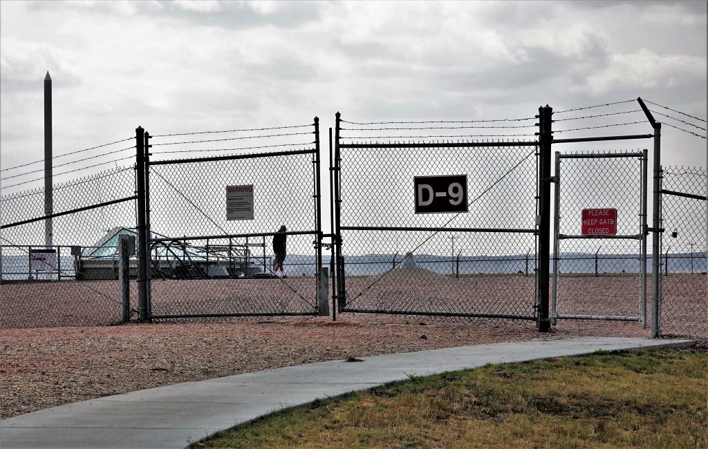
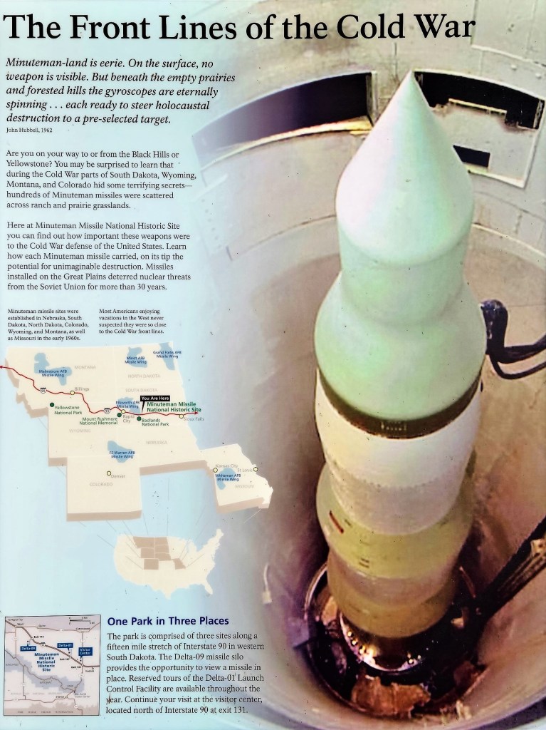
From 1963 to 1993, one thousand Minuteman II missiles (ICBMs) capable of delivering a 1.2 megaton nuclear warhead to a Soviet target in 30 minutes were housed in underground silos like Delta-09 that stretched across the Great Plains,

(Library of Congress)

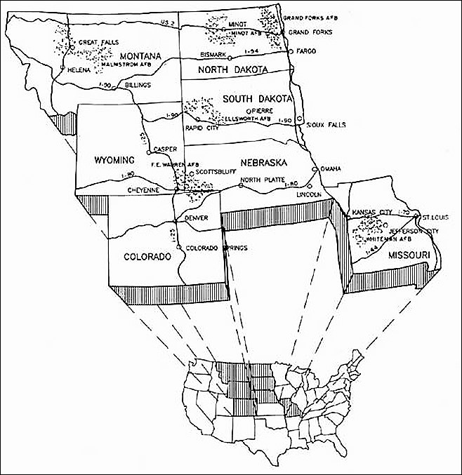
with 150 launch sites dispersed throughout South Dakota, transforming the serenity of the prairie into a hibernating military zone.

(Library of Congress)

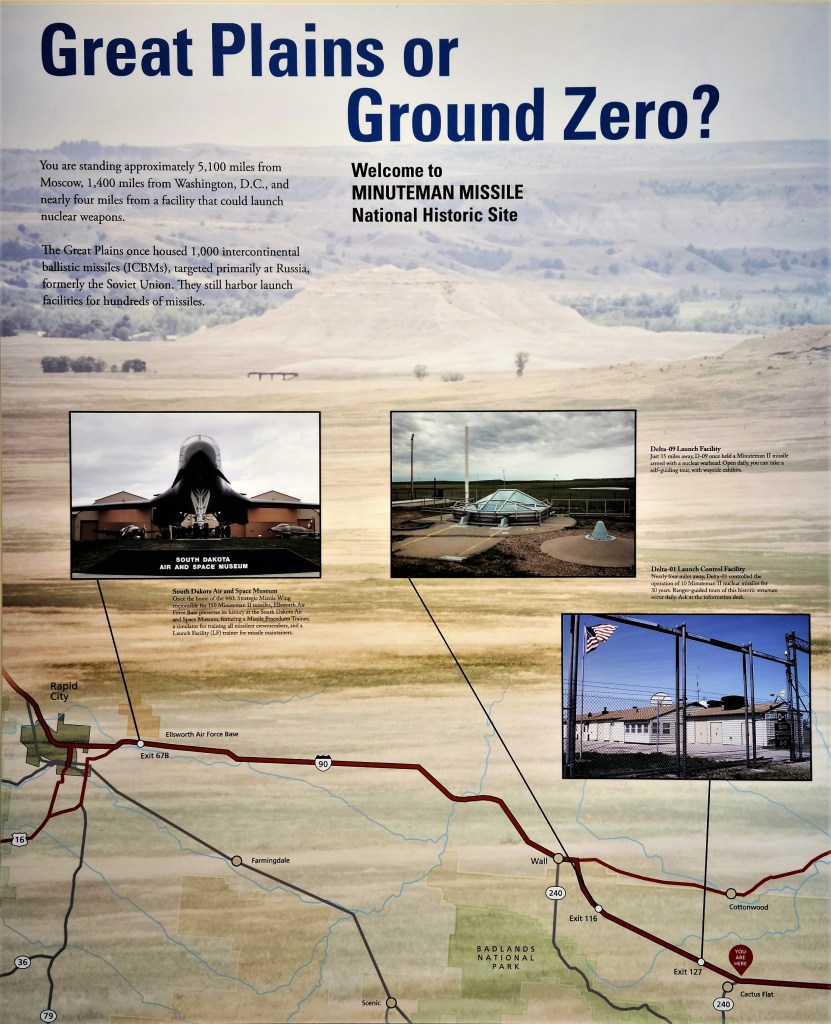
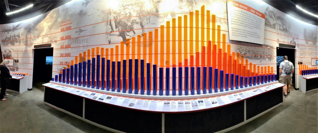
The Minuteman Missile National Historic Site commemorates a period in America’s history when “Mutually Assured Destruction” (MAD) imperiled the world, and delves into the birth of the Cold War, the nuclear arms race, and development of ICBMs.

At the height of the Cold War between Soviet Union and United States there were more than enough nuclear missiles in both arsenals to destroy the planet 5 times over.

As I walked through a maze of interactive exhibits, childhood memories came flooding back.

While growing up in an era of “duck and cover” mindfulness, we were acutely aware of the danger outside our global window.

With the school claxon sounding in 3-clang intervals, my classmates and I responded by hunching under our desks in silence until the principal gave us the “all clear” over the PA. It was our way of showing the Commies that we were prepared and doing our part in the recurring struggle to keep ourselves safe from a political bogeyman.

Of course, as we got older (these drills lasted through middle school), we doubted that “duck and cover” would ever protect us from a nuclear firestorm or subsequent fall-out.

Because of the Cuban Missile Crisis, and the realization that Pittsburgh’s steel mills were a likely military target, my father’s master plan in the event of a nuclear attack was to convert our basement closet filled with dusty canvas awnings and rusted paint cans. We painted the concrete blocks a putrid shade of green under the glare of a single dangling light bulb swinging from the ceiling, and filled the 6 x 6 closet with mattress slabs, jugs of water, and a box of batteries for our flashlights. I always wondered how our family of four (at the time) would survive inside this moldy space.

After touring the Visitor Center, we rode 15 minutes on I-90 West to a decommissioned missile silo roughly the size of a football field, and the feeling was ominous.

Locked beneath a sliding 9-ton hatch…

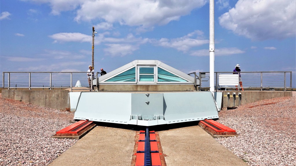
was a vertical rocket in-waiting. I pressed against the tinted, transparent armor and peered into a hole 185 feet deep for a first look and a photograph.

Despite being disarmed,

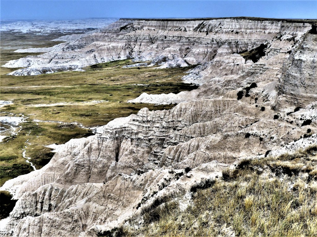
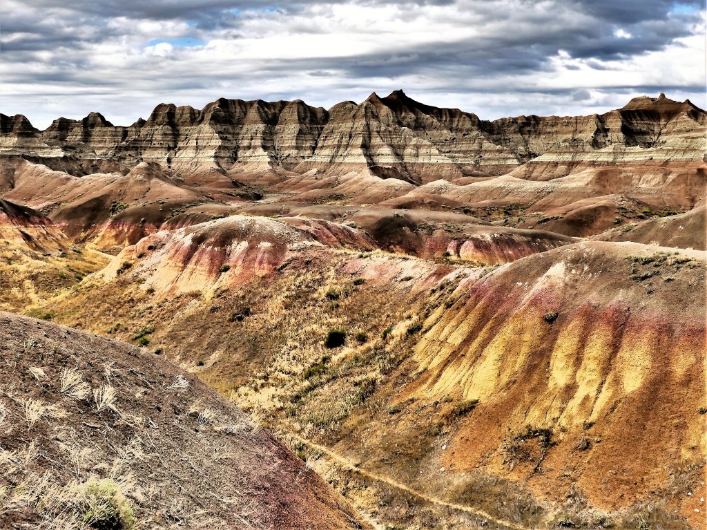
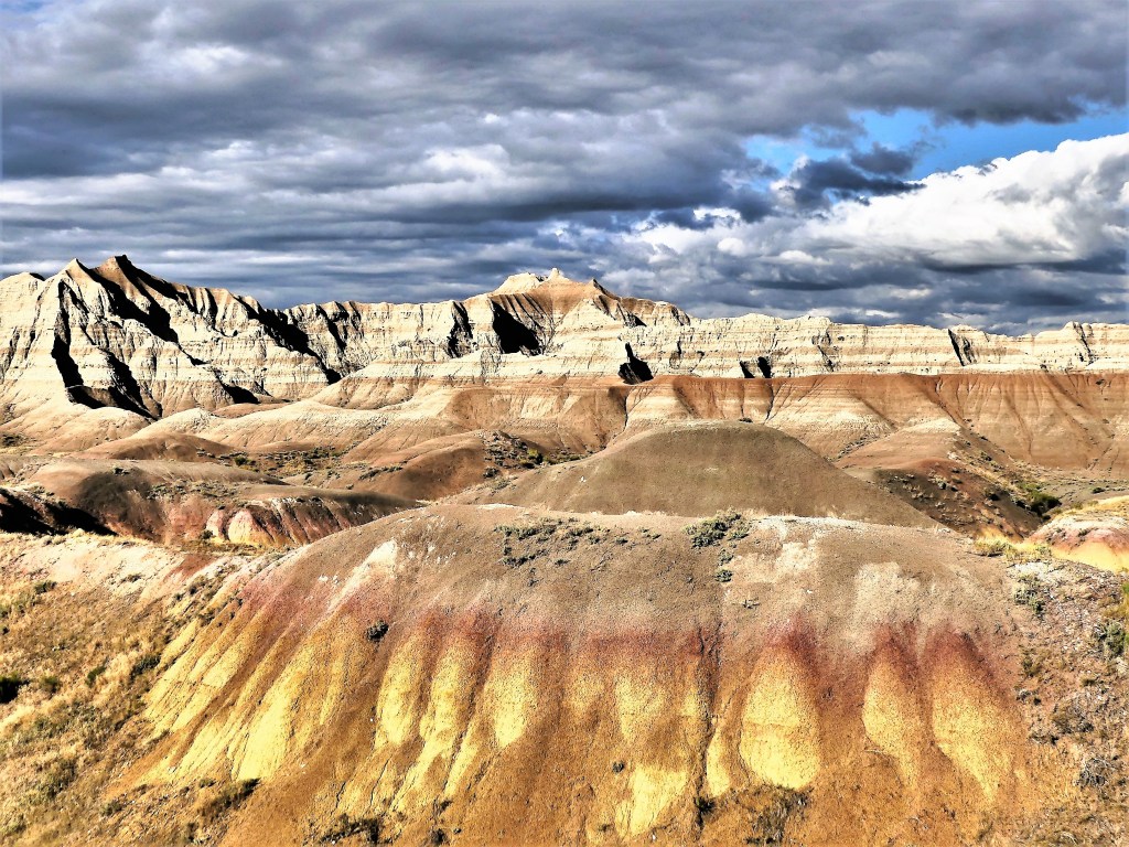
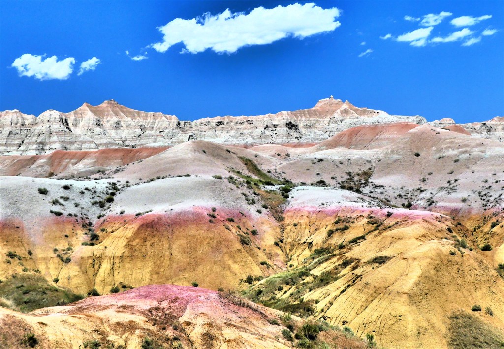
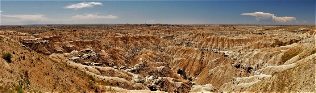
it was no less unsettling to consider that humanity holds the power of mass destruction, and the Badlands backdrop–75 million years in the making–could vanish in an instant.

Babylon Badlands: True Religion

There was a time 10 years ago, when Scenic, South Dakota was for sale–yes, all 10 acres of the town and 36 acres of the not-so-scenic, surrounding property.

It was originally offered up for $3M by Twila Merrill, local rodeo legend who earned a tough-as-nails reputation for never being thrown from a bucking bronc from 1956 to 1963, but with her health fading, it was time to sell.

She eventually sold the whole kit and caboodle to a Filipino church group for just shy of $800,000 in August, 2011.

Ten years later, Scenic looks unchanged. There is scant evidence that parishioners of Iglesia ni Cristo (Church of Christ) are welcome at this ghost town, although the pastel-colored Adirondack chairs on the porch suggest that a resurrection of activity is possible.

Back in the day, Scenic was a thriving hive of entertainment, with a full-scale rodeo arena, a racetrack, a manicured baseball diamond, a theatre and a dancehall.

Main Street was home to a General Store,

and a requisite saloon which was thoughtfully annexed to the town hoosegow.

It should be noted that Indians were allowed inside Longhorn Saloon, but only after Twila bought the joint and painted over “NO” on the marquis.

Meanwhile, the culture crowd would gather at Sam 2 Bulls.

Off the main drag, there’s an assortment of incongruous buildings: a couple of standing churches, a few warehouses and barns, a defunct gas station, and a post office behind a dedicated monument featuring a pterodactyl that defies logic or explanation.

Leah and I rolled through Scenic, on our way to an outpost of Badlands National Park known as Sheep Mountain Table, located in the Stronghold Unit within the Pine Ridge Indian Reservation.

At 3,300 ft. elevation, Sheep Mountain Table is the highest point in the park.

The good news is that we could drive to the top.

The 6.5 mile road was hard-packed and serviceable all the way to the top of the table, albeit a single lane and a handful of hairpins. Once we arrived, there wasn’t much to see on the surface except tall grass, road tracks and traces of spent and unexploded ordinance scattered throughout this one-time gunnery range used by the USAF and South Dakota National Guard. The wind was blowing furiously,

which kept us anchored a careful distance from the ledge overlooking the Cheyenne River Valley.

But there was much more to explore on the other side of the table, which we could reach by hiking 2 miles or driving the rutted terrain…

so I drove…pitching and rolling along…

until we arrived at an open plateau with dramatic vistas to the west…

and the White River Valley to the east.

These Badlands were once considered sacred to young Sioux braves who would trek to the tables for prayer and self-reflection as they approached manhood.

That’s when it occurred to me that Scenic, South Dakota was rightfully named, not because of the town’s location, but because of the Badlands omnipresence and its omnificent landscape. And that may also explain why the Filipinos invested in Scenic.

Badass Badlands: a Surreal Landscape

Pillars and spires, pinnacles and hoodoos, canyons and gorges, ridges and ravines, bands of colors and beds of fossils, mixed-grass prairies and resilient wildlife…the Badlands of South Dakota are a scenic recipe so fantastic that I sometimes wondered if my camera could adequately capture the range of strangeness that surrounded me.

But I was up for the challenge!

What follows is a visual diary of Badlands National Park…told in 3 parts.

The Yellow Mounds of Dillon Pass

From a distance, this mustard-colored landscape qualifies as the perfect location for a film shoot on an alien planet.

Leah and I were casually driving along the Badlands Loop Road near Dillon Pass,

when the Yellow Mounds popped into view…

and I knew that I had to explore this phenomena more thoroughly.

I climbed atop one of the mounds…

which overlooked a network of foot paths…

to the Pinnacles on one side of the hill,

and offered an outstanding overlook of the Conata Basin to the southwest…

and beyond.

And as I surveyed the scene below,

I realized that the scope of South Dakota’s Badlands defies framing.

The Badlands cannot be contained, and the sheer beauty and colors transcend any exposure.

Biking the Black Hills

During our travels across America, Leah and I have cycled on several amazing rail trails–each one offering a variety of gorgeous scenery, interesting terrain, historical context, and wildlife features. The Black Hills of South Dakota boasts the George S. Mickelson Trail, which checks all the right boxes.

The trail follows 109 miles of Burlington Northern’s historic rail line from Deadwood to Edgemont–

crossing 100 converted railroad bridges…

and pedaling through 4 tunnels.

The result is breathtakingly beautiful.

Named after South Dakota’s governor following his untimely death in 1993, George S. Mickelson’s ardent support was instrumental in creating a non-motorized mixed-use trail,

from his dedication of the first 6 miles in 1991 to the trail’s completion in 1998.

Rather than limiting our linear miles, we rode the trail from Dumont (its highest elevation point at 6240 ft) to Hill City,

and hired a taxi service to transport our bikes back to Dumont.

The trail consisted of crushed limestone and gravel which was perfect for our road bikes clad with all-terrain tires.

While riding the trail was effortless (mostly a slow downhill roll), there were many reasons to stop:

whether to soak up the landscape;

or reflect on South Dakota’s cultural heritage–such as farmers using cyanide lids left over from Deadwood’s Gold Rush days to shingle and side their houses.

All of which made for a glorious outing,

which only adds to the allure of Black Hills lore.

What’s Mine is Mine

Leah and I were prospecting for wedding bands along downtown Deadwood’s famed historic Main Street when we ran into a local miner–a chip off the old block–who told us that touring the abandoned gold mine on the edge of town was a hoot and a value-added experience.

Broken Boot Gold Mine has been running tours and amateur gold panning since reopening as a visitor attraction in 1954–long after the last ounce of gold was discovered.

The 15,000 ounces of gold extracted from Sein’s Mine (1878 -1904) through pickaxe and candlelight was hardly the mother lode the Sein Brothers had hoped for, but a rich vein of iron pyrite (also known as fool’s gold) ran through the mine, and that was just enough to make the mine profitable…for a time.

The mine closed in 1904, but reopened in 1917 to extract iron pyrite for the war effort. After a year, all mining operations stopped and the mine went quiet…

until Olaf Seim’s daughter (and sole heir) was persuaded by promoters to segue Sein’s Mine into Broken Boot Gold Mine–thereby creating a new tourist experience and de facto location for shlock horror movies…

According to the operators of Broken Boot Gold Mine, “[it] has operated longer and more successfully as a visitor attraction than it did as a working mine.”

Leah and I made a $14.00 investment (seniors get a $1 discount), which got us a 40-minute walk-thru and Wild West mining advice. We donned our plastic pastel safety helmets and entered a tunnel that was dim and chilly.

We crept through reinforced passages with 10 other investors,

and imagined a 10-hour shift in relative darkness–about the time it took to burn through one candle–while searching for precious metal,

and valuable mineral deposits.

Our guide reinforced the feeling of claustrophobia by switching off the lights and allowing our eyes to adjust to total darkness before lighting a single candle, a miner’s only light source.

Despite the price of gold hovering near $1,800 per ounce, few amateur miners were willing to spend an extra 10 bucks for gold panning lessons after the tour…

while Leah was completely satisfied with her bogus stock certificate.

Dateline: Deadwood, SD

Leah and I deliberately planned our arrival to Deadwood to coincide with the conclusion of the 81st Sturgis Motorcycle Rally, and for good reason. This year’s 10-day event brought 700,000 bikers to Deadwood’s neighbor town of 7,000 residents amid the highly infectious Delta variant–without vaccination, testing or masking requirements–which from a Covid-19 perspective is equivalent to shoveling 100 pounds of shit into a 1-lb. bag.

Adding perspective to our paranoia, last year’s event qualified as the nation’s #1 super-spreader of the summer when 462,000 gathered for the rally–infecting 649 with Covid, and contributing to soaring hospitalizations throughout the region, according to the Centers for Disease Control.

Despite the many Harleys that lingered at our campground beyond the last tequila shots and freshly inked tats, the streets of Deadwood were relatively crowd-free. We weaved around occasional families, and dodged small gatherings of people dressed in leather vests when they were missing masks.

Because we had little interest in repeating the same activities that brought us to the Black Hills 4 years ago–albeit still wanting to be safe in the process–we decided on pursuits that would limit our exposure to the Delta variant, like: cycling on the George Michelson Rail Trail;

touring a gold mine on the edge of town;

and strolling through Mt. Moriah Cemetery…

which I’ll detail now, with the other activity highlights to follow in future posts.

On a clear day, the best view of Deadwood gulch and the surrounding Black Hills comes from Mt. Moriah Cemetery, rising 200 ft. above town. And from the look of early photographs taken from the edge of Deadwood’s Boot Hill, not much has changed.

Thanks to the 23 casinos across town, the revenue taxed from gaming has funded the Deadwood Historic Preservation Commission which provides loans and grants for large-scale restoration projects that manage to keep the 19th century vibe alive.

When strolling down Main Street, it’s easy to imagine the likes of Jack McCall sneaking up on Wild Bill Hickok while he played a hand of poker at Saloon #10,

and shooting him dead in the back of the head on August 2, 1876.

Wild Bill’s final resting place is just beyond the cemetery gates.

Calamity Jane, per her dying wish, keeps him company next door.

However, it was widely known that Wild Bill had no use for her and considered her a nuisance, which makes their graveyard union the cruelest of eternal jokes.

There are many distinct sections of Mt. Moriah Cemetery:

A children’s section of unmarked graves calls attention to a time of heartfelt tragedy;

In Section Six, an alter for offerings to departed spirits denotes the thriving community of 400 Chinese immigrants who followed their dream of striking it rich during Deadwood’s Gold Rush. Thirty-three souls were buried in Section Six, but only three remain, with the majority having been disinterred and returned to China;

There is a Soldiers’ Lot of Civil War veterans administered by the NCA;

But most interesting is the Jewish section, known as Hebrew Hill, honoring many Jewish pioneers who made significant civic, commercial and social contributions to Deadwood society, notably:

Harris Franklin, an immigrant entrepreneur from Prussia who amassed a fortune through banking, ranching, mining, and hospitality, and whose son became the the second mayor of Deadwood;

and Nathan Colman, who became Deadwood’s life-long elected Justice of the Peace, and lay Rabbi for the Jewish community for more than thirty years. His daughter, Blanche was the first woman from Black Hills to be admitted to the South Dakota Bar.

Oddly, Solomon Star is missing from Mt. Zion. He died alone on his Deadwood estate in 1917, and was thrown a lavish funeral fit for a king by the townsfolk…but he was buried in St. Louis.

Sol Star was a dedicated public servant, who served on Deadwood’s first town council before becoming Deadwood’s ten-term Mayor. He was elected to the State House of Representatives, and won a seat in South Dakota’s State Senate shortly after. He finished his civic career as Lawrence County’s Clerk of Courts for twenty years.

But if that wasn’t enough, Sol Star was also a long-time business associate of Seth Bullock, the undisputed king of the hill…

from where he shares unimpeded views of the Black Hills with his wife, Martha beside him.

Seth Bullock’s origin story is an essential part of Black Hills lore. He arrived two days after Wild Bill was murdered and was quickly appointed Deadwood’s first Sheriff. He was an imposing figure who got the job done without ever killing a man or woman.

He celebrated his deeply personal friendship with Teddy Roosevelt by building The Friendship Tower atop a peak in the Black Hills National Forest 2.5 miles from Deadwood…

and declared it Mount Roosevelt.

All the history that’s baked into the bones of Deadwood’s dearly departed, and all of the iconic imagery that’s scattered among them are references and remembrances of a time when people pulled together and persevered.

Together, they tamed the Wild West. Together, they defeated lawlessness with civility, and went on to create a diverse and inclusive community that was determined to improve their condition through mutual cooperation.

And they accomplished this in the midst of Black Hills, South Dakota…

which helps to restore my faith in optimism.

Rock Art

Billings was our final stopover in Montana before continuing east to Deadwood, SD. Upon arrival, Billings health officials issued a local advisory restricting outdoor activity due to a blanket of smoke and ash that had invaded the valley from several regional fires that were burning unabated.

While we would have preferred exploring the winding trails through the Rimrock Bluffs–overlooking the Yellowstone River and town–we lowered our expectations, given the extreme heat and unhealthy air quality index, and opted for a brief walking tour through Pictograph Cave State Park, known for its natural and cultural significance.

Just a 5-mile jaunt south of Billings, we approached a sandstone bluff in the shape of a horseshoe, and turned into an empty parking lot. Surprisingly, the Visitor’s Center was open and filled with a variety of artifacts that WPA workers recovered from the cave floor between 1937 and 1941–considered the first major archeological excavation on the Northern Plains.

In all, over 30,000 artifacts were discovered, with some dating back over 9,000 years.

We cautiously hiked up a narrow, sandy footpath through sprigs of yarrow and juniper shrubs, hoping to avoid an encounter with a prairie rattlesnake or bull snake…

until we reached the mouth of Pictograph Cave, revealing a stone wall that was once part of a ceremonial lodge. The dotted line above the left side of the wall structure was drawn by WPA workers to mark the original floor line before they began digging.

We stood motionless for a beat to allow our eyes to adjust to the shadows, before scanning the cave in search of ancient charcoal and red markings. Even with the help of graphic displays that emphasized these creations,

it was no less a challenge to identify the drawings due to a veil of calcium that had formed over the pigment during a dry period. These figures were carbon dated between 1480 to 1650 A.D.

The red pigment was created from an ancient recipe combining ground up hematite (concentrated iron ore) with assorted binders such as animal fat, berries, blood and adjusted with water or urine while heated to form a paste that was applied by finger or stick.

A rack of flintlock rifles that were painted within the last 200 years is located no more than 15 feet away from the other figures.

While not the easiest to decipher, a nearby graphic makes it more apparent.

Continuing our walk along the cliff, we reached a middle cave with evidence of clams fossils and other sea life embedded in sandstone that likely lived during the late Cretaceous Period when this portion of America was under water.

Then up a rising that followed the curvature of the cliff, we reached the Ghost Cave. While no drawings were discovered here, a series of round boulders known as concretions formed as a result of a clam bed that was exposed when the sea eventually receded.

These cliffs continue to evolve as winter ice cuts through brittle stone; massive rains charge over the cliffs, turning into intermittent waterfalls; and smoke ash eats away at porous surfaces.

While the evolution of our landscape is inevitable, we must look for ways to tap the brakes on what’s creating the intensity and severity of our man-made issues, and allow nature to take its true course.

After all, it’s not supposed to be this hot; it’s not supposed to be this dry; and it’s not supposed to be this smoky during Montana summers.