Thunder Mountain

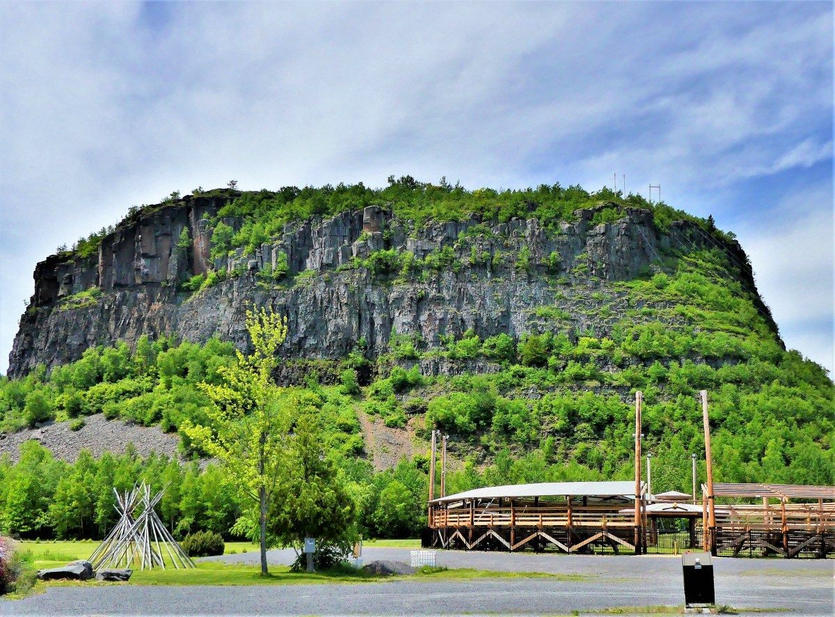
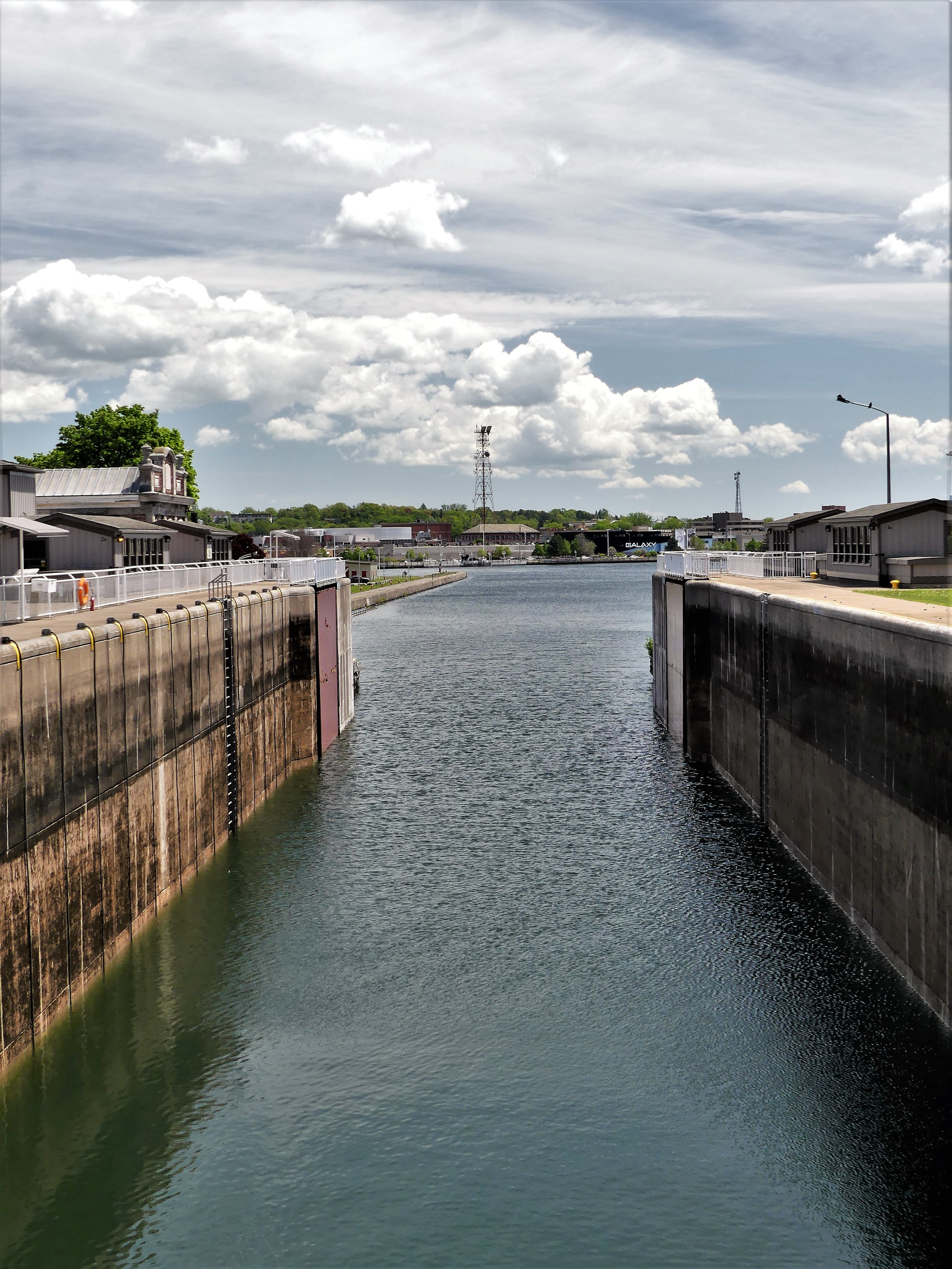
From a distance, Mt McKay is imposing, rising 1200 ft over Lake Superior and making it the largest of the Nor’Wester mountains. It gets its name from William Mackay, a Scottish fur trader from the mid-1800s, who lived for a time in the Fort William vicinity.

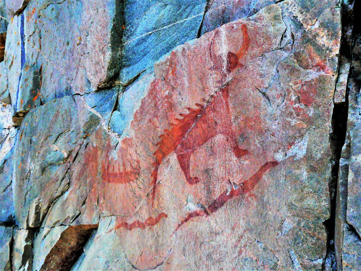
However, the Fort William First Nation, descendents of the Chippewa tribe, call the mountain Anemki Wajiw (ah-NIM-ih-key waw-JOO), meaning Thunder Mountain,

Thunder Mountain

and consider it sacred land.

In Honor of Our Ojibwa Elders

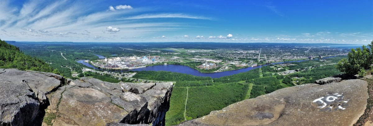
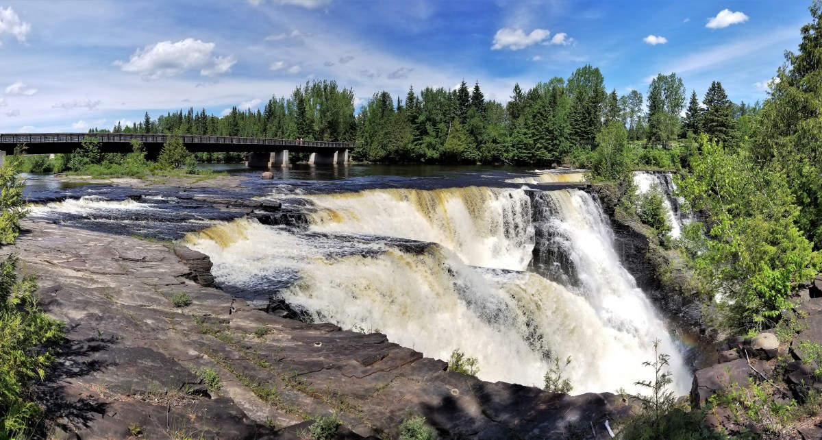
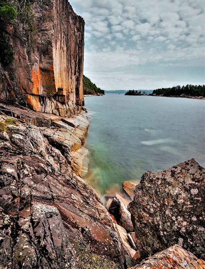
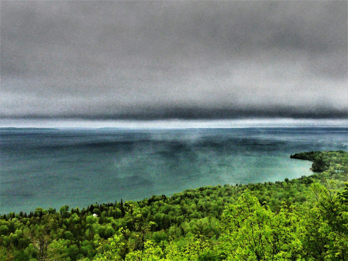
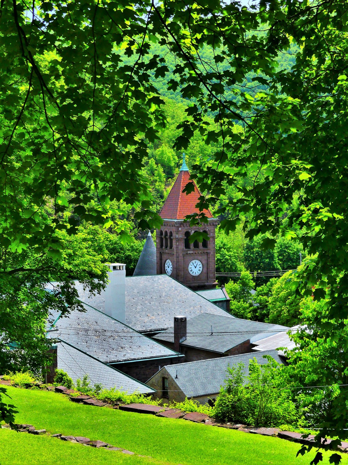
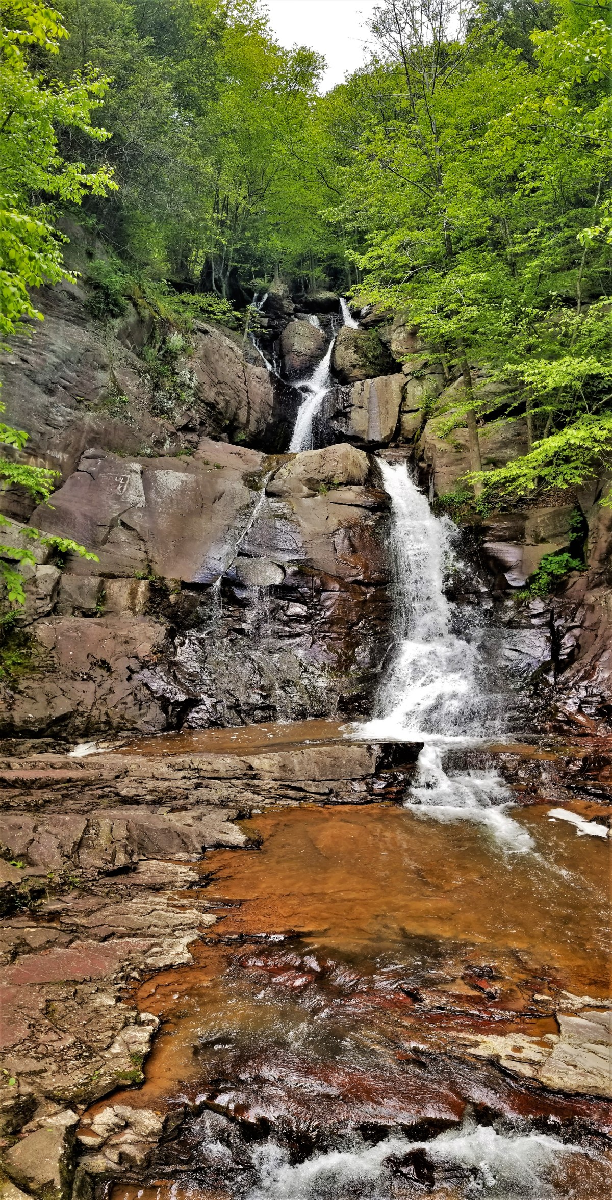
Mt McKay is a prominent landmark of the Fort Williams First Nation reserve, and offers sweeping views of Thunder Bay…

plane landing

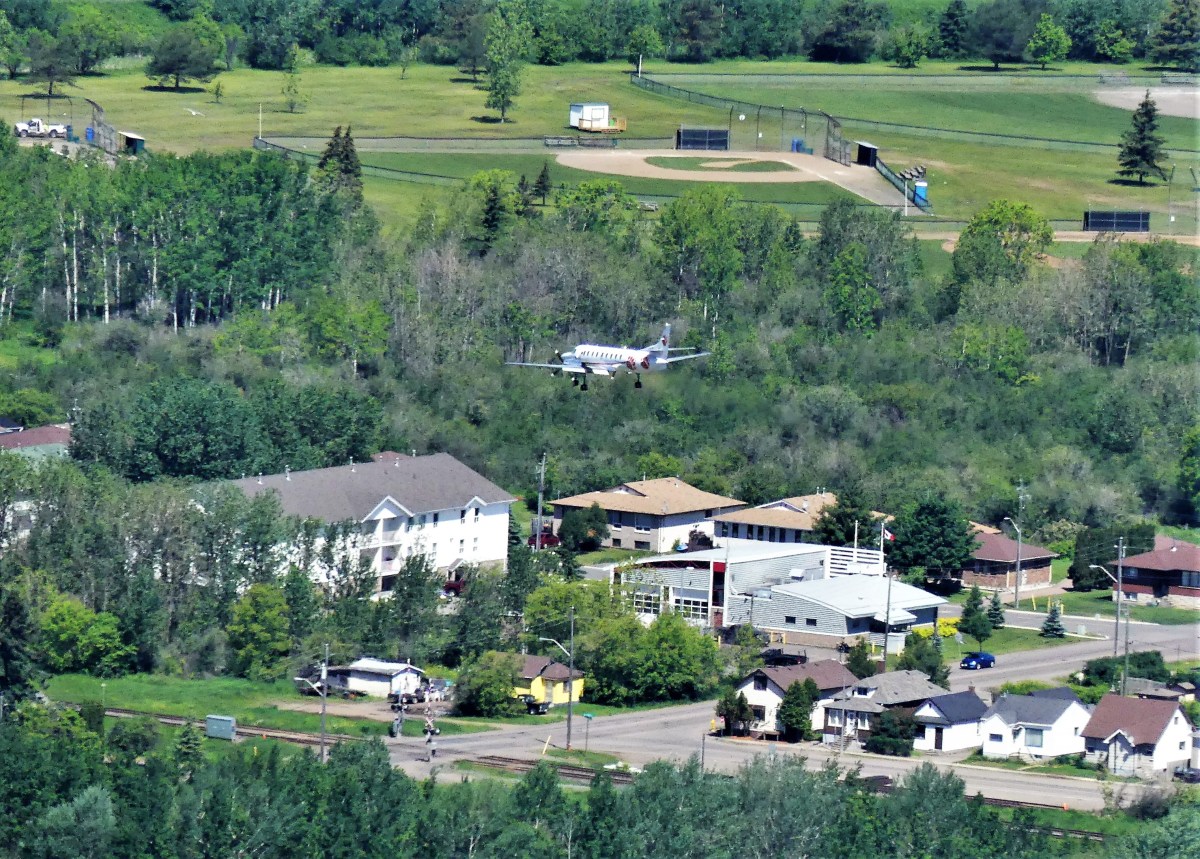
from its boardwalk overlook on the eastern plateau…

boardwalk to overlook (2)

and beyond…

Fort William First Nation

Leah and I drove up Mission Road to a toll house, where a First Nation member collected $5.00. She advised us to hike the western trail to the flat cap for more commanding views, and encouraged us to return in 3 days to witness a powwow of the Lake Superior chapters. She also offered a menu and invited us to visit her lunch counter in town.

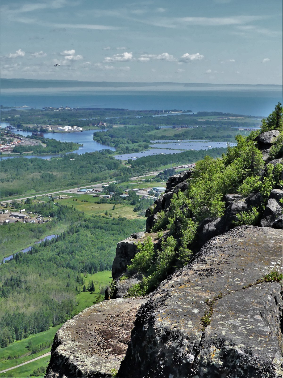
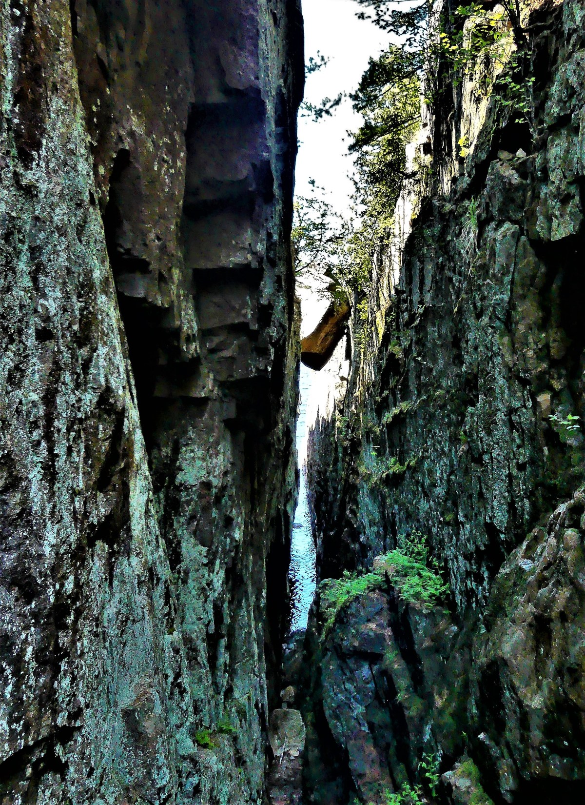
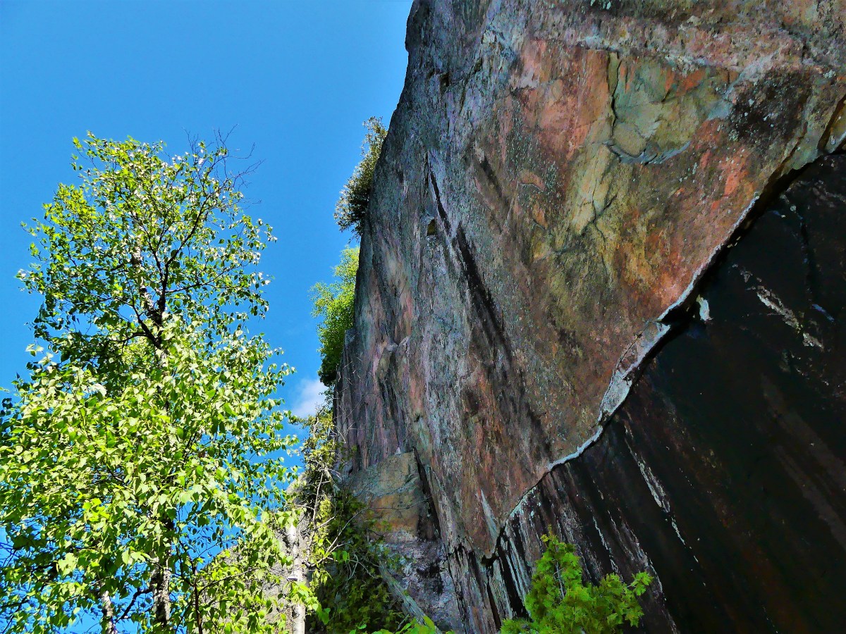
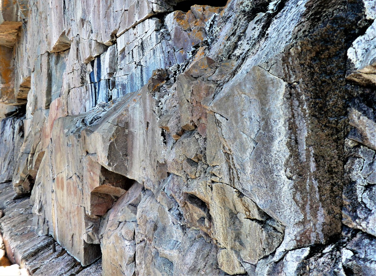
The trail was narrow, steep and challenging with shards of shale scattered over rocky formations. We took our time.

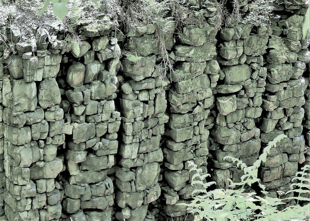
After a weary climb of 40 minutes, we welcomed the cooler air around us as we crossed onto a plate of volcanic rock formed over 1,100 million years ago.

Leah and me

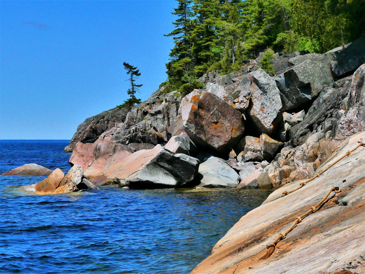
The bright sun promised a crisp and dazzling vista,

Thunder Bay overlook

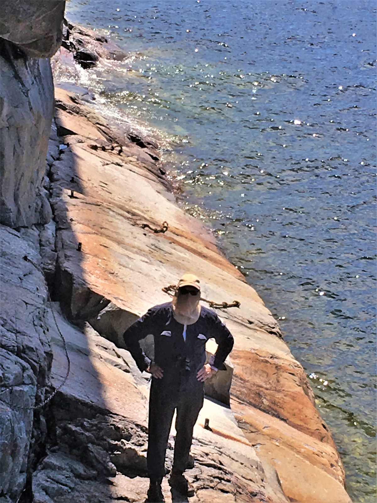
but it also seemed to energize the horse flies that soon regarded me as bait.

harbor view

That’s when I knew it was time to retreat to the bottom of the hill, oh-so-gingerly over long drops onto loose shale.

Once we landed at the trail head, I had decided (after checking with Leah) that we should attend the powwow on Satuday.


On the day of the powwow, we looked for news on the internet. and it was everywhere. The council was expecting over 5,000 attendees over two days with plenty of drumming and dancing. Food tents and crafts stalls would round out the affair. The rules were simple: No Alcohol. No Drugs. No hiking. Have a Safe Time.

We drove to Fort Williams First Nation ice arena, where we met a yellow school bus that shuttled us the rest of the way. Only three days ago, the area was empty and quiet, but today, it looked like a parking lot next to a fairground with fringe tents and trailer camping.

Participants were gathering inside the spirit circle and adjusting their costumes, while spectators were filling the grandstands, and the royalty was assembling in anticipation of the welcoming ceremony.

Welcome ceremony

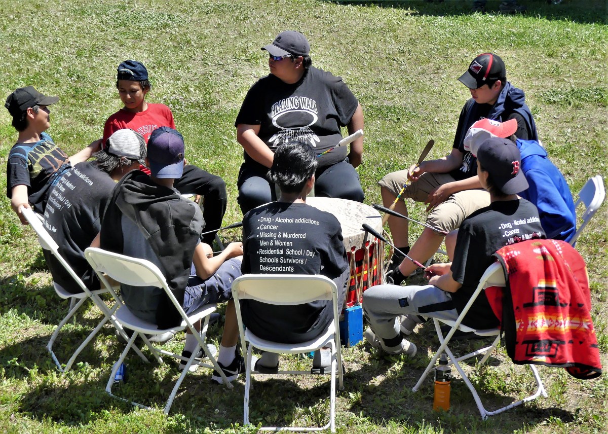
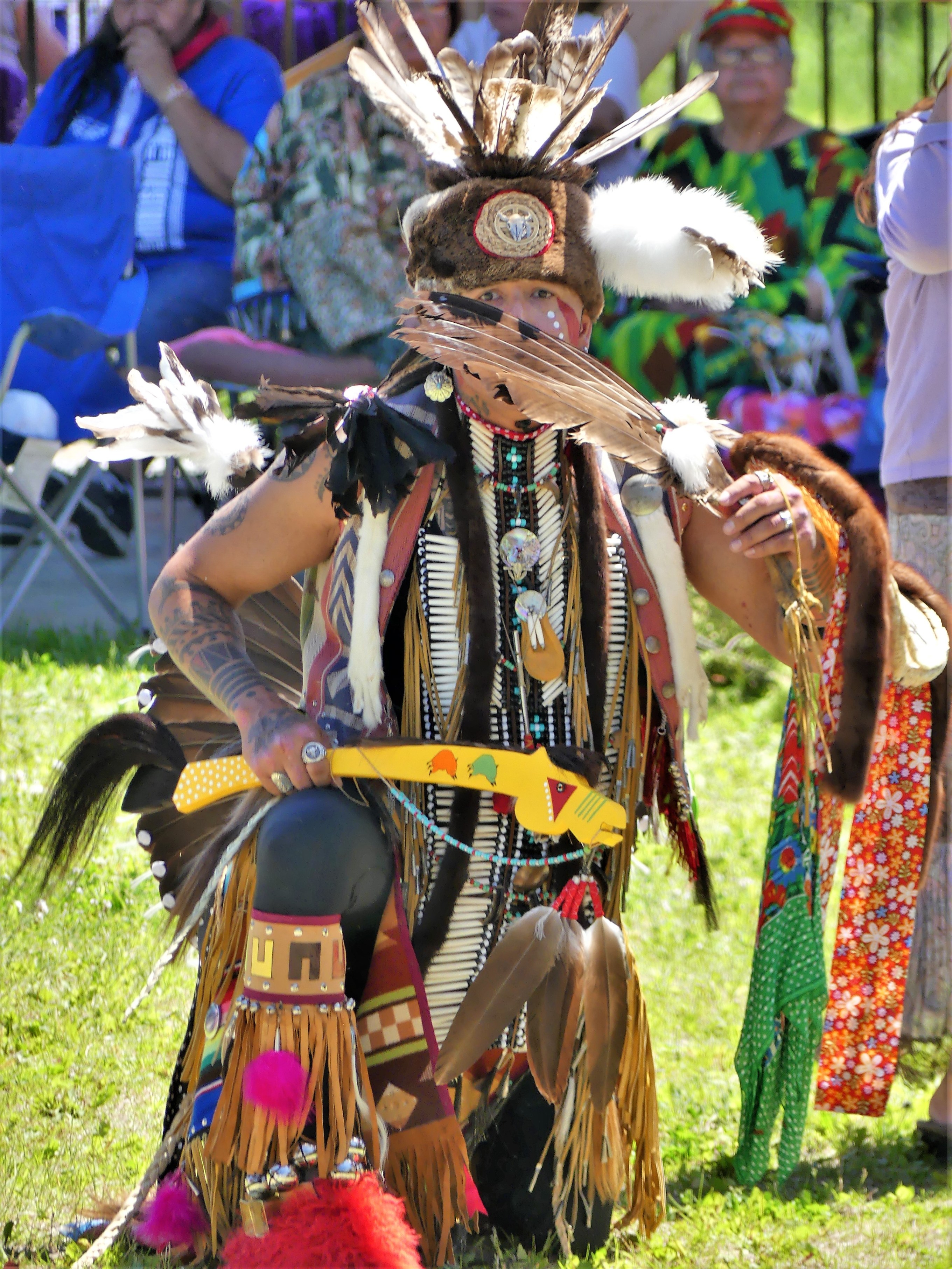
It was a colorful and festive affair. A steady drum beat managed by eight drummers, accompanied a caterwauling chant of guttural highs and lows and occasional shrieks.

drum circle

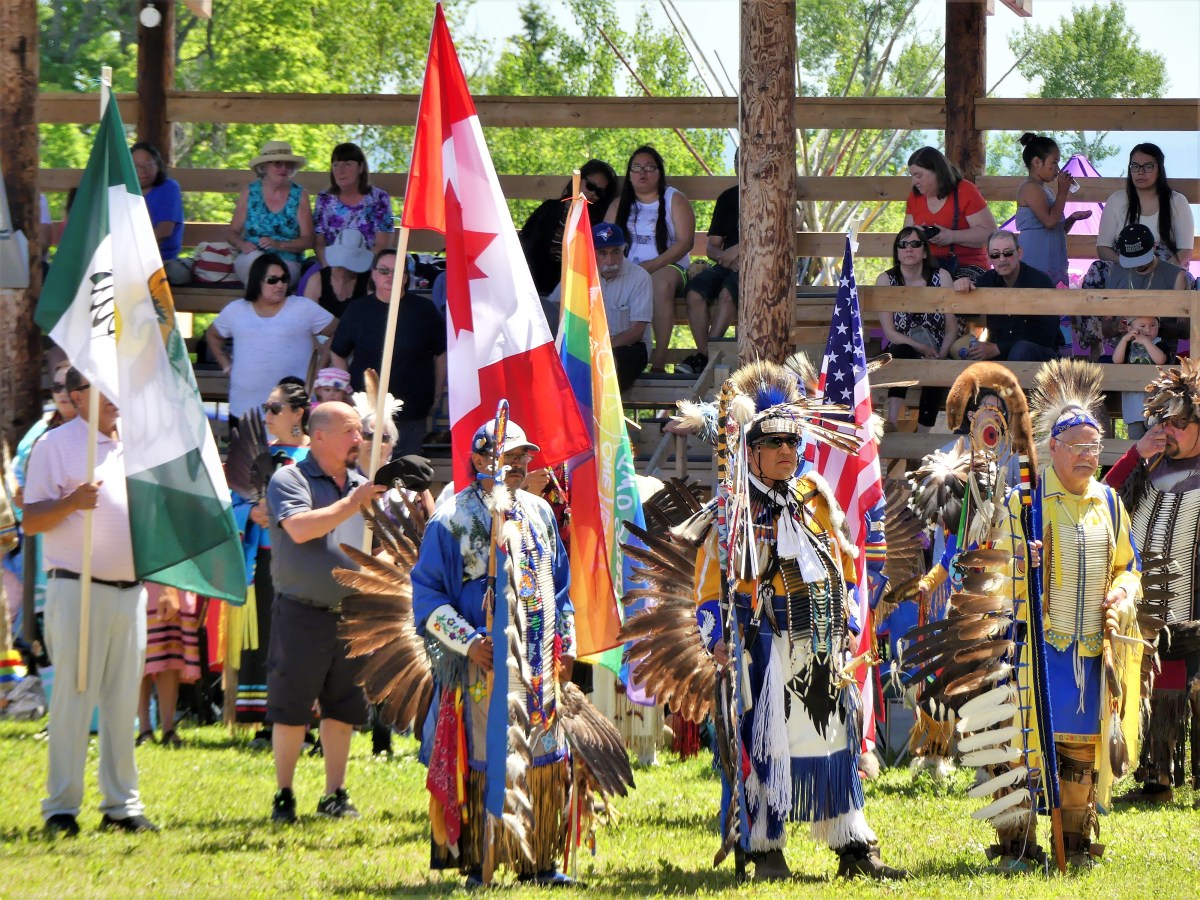
After a prolonged opening procession and invocation, Chiefs and Elders presented flags,

Chiefs

and then it was time to drum and sing and dance again. Grass dancers followed Elders…

grass dancers

who were followed by family members…

procession

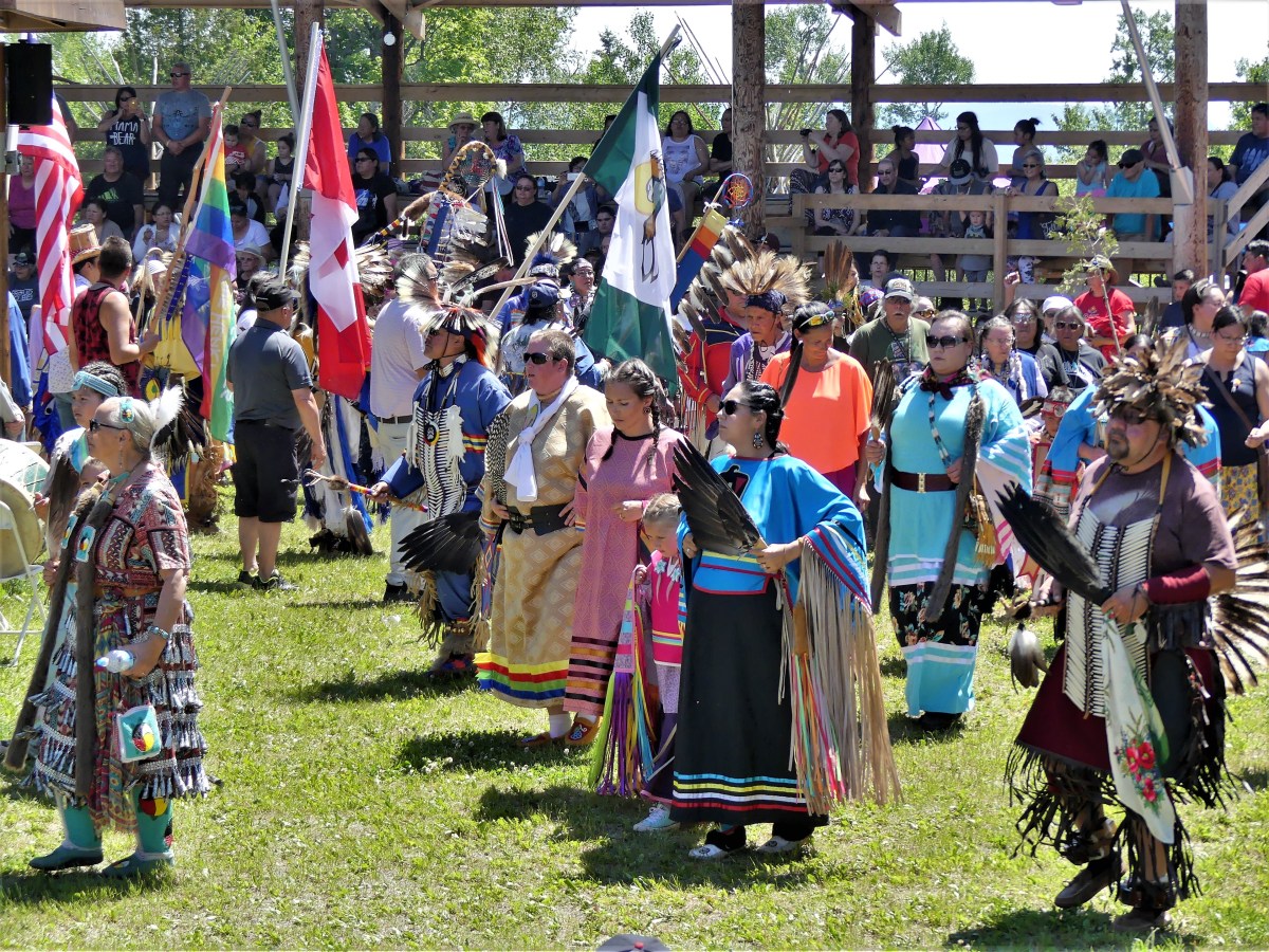
who also danced several times around the pavillion with their children…

father and son

tiny dancer

showing off their feathers,

eagle feathers

their elaborate ceremonial costumes…

teal man

red costume

blue costume

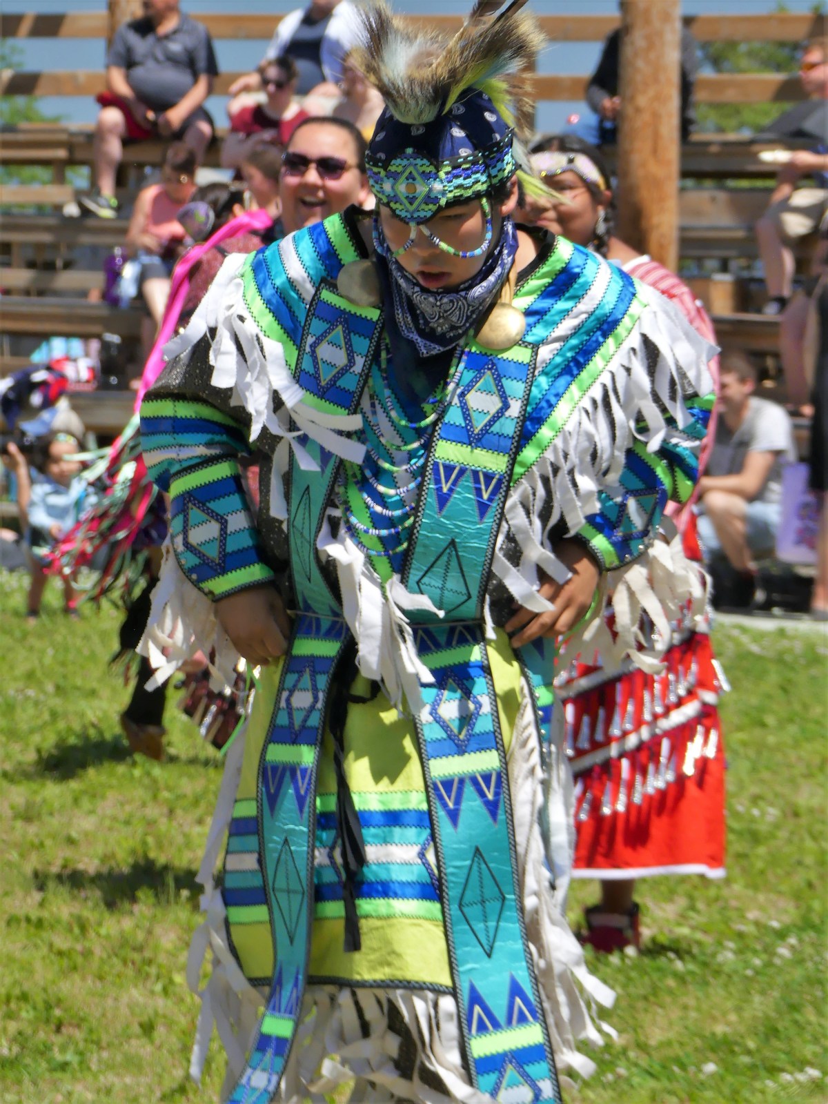
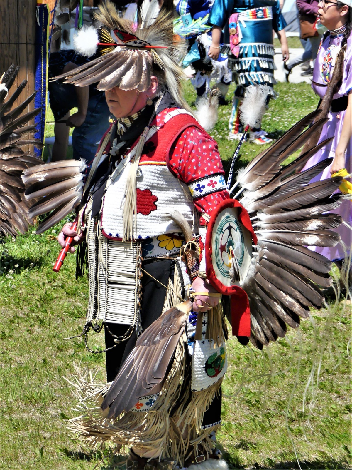
and their elaborate moves…

Little Bear 2

Little Bear

Little Bear 1

After a couple of hours, Leah and I returned to the boardwalk for a stroll to the memorial,

WW1 Indian memorial

where we discovered a trail to the right that hugged the cliff around the plateau. We hiked further along, scouting for poison ivy as we walked, and came to a clearing where three girls in training bras were sneaking cigarettes around a slab of concrete.

It was an amusing irony and signaled our time to return to the ice arena. The school bus that brought us circled the field–collecting passengers–and momentarily paused at a graphic display of Ojibwe insight and life lessons:

Ojibwe Code

They are good words to live by!

Neys Provincial Park

Dear Diary,

Today was unsettling, as nothing went as planned.

A high probability of intermittent rain had been forecasted throughout the day, which gave us very few options. Although we were snug in our pull-through campsite overlooking the northern boundary of Lake Superior from Neys Provincial Park in Ontario, Canada, we were looking forward to exploring the stark coastal beauty of an area once known from 1941 to 1946 as Neys Camp 100–an internment facility for German POWs and Japanese Canadians.

detention sign

Prisoners arriving (2)
Kreigsmarine and Luftwaffe prisoners of war arriving at Neys, ca. 1941

Prevailing wind from the west had whipped up whitecaps across the water, and threatening skies promised to restrict our outdoor time, but we were determined to make the most of current conditions: buggy, chilly, yet dry.

Terrace Bay

A short walk to the Visitor’s Centre for sight-seeing suggestions proved useless since the door was locked–maybe from campground inactivity, I surmised. There was, however, an interesting park bench design overlooking the lake by Sean Randell. 

Trout bench Neys PP

With 144 sites covering 4 areas, Leah and I spotted less than a dozen occupied sites. Many of the seasonal campers left their trailer set-ups behind for greater comforts nearby. With electricity only provided at less than half the sites, we had the showers practically to ourselves.

We were determined to get a hike in, so we selected the 1 km Dune Trail loop for its brevity (in case of sudden rain), and our fascination with sand dunes by the lake. We followed each other single file through a skinny path snaking through a plantation of red pines and a forest floor of lichens, mosses, and herbs. But we never found the dunes–only rolling mounds of sand over soil. We began the hike with an interpretive trail guide corresponding to 7 markers, but mosquitoes quickly put an end to that. We found ourselves marching through the forest just to complete the loop. The roundtrip walk to the trailhead proved to be longer than the entire trail.

With a faint drizzle falling, we planned a 35-mile drive to Terrace Bay, following TransCanada Highway 17 west around the top of Lake Superior, but the truck refused to start. Earlier in the week, I was stuck in a parking lot under similar circumstances, but Leah located a Samaritan willing to give me a battery boost. Today, however, was a different mater. After shlepping a spare battery around America for tens of thousands of miles, I finally got a chance to use it.

The battery installation set us back half an hour. And then the sky opened up the moment I dropped the hood and climbed inside the cab. It was an auspicious moment in my life!

We finally arrived at Terrace Bay (pop. 1100) and descended an elaborate boardwalk to a high viewing platform that distanced us from Aquasabon Fall’s 100-ft. drop,

Aquasabon Falls

and the granite gorge that carries the spill water to Lake Superior.

Aquasabon Falls and Gorge

Back at the boardwalk entrance, I stood alongside a millennial male. We were studying an oversized graphic together about the geological properties and commercial significance of the Falls.

Falls and Gorge graphic

My neighbor had a cat perched on his shoulder wearing a harness with a leash. Suddenly, a light rain began to fall, spooking the cat. It leapt to the ground, surprising the host. He had control for a moment, but it squirmed out of his arms, and wriggled free of its harness. He dove for the hind legs, but the cat was too fast. It bolted 50 yards to the trees, and disappeared in the brush with his girlfriend chasing after it and screaming its name. We briefly watched in amusement, wondering if the cat would reconnect with its owners, but we had our doubts.

While in town, we filled the truck with $130 Canadian of gas, and searched for a lunch spot, but ended up at a Chinese Canadian restaurant in a strip mall just to use the internet. I had fried chicken balls (no joke), and Leah ordered dry-rubbed spare ribs. The food was as disappointing as a dead car battery and tasteless as a lost cat in the woods.

spare ribs

A stubby white lighthouse planted in front of the strip mall parking lot offered a view of Lake Superior. To Leah’s amazement, I passed on a picture of the tower and a view from the bridge. 

The ride back to Neys was rainswept and uninteresting except for a cow moose that galloped across TransCanada Highway 17, followed closely by two calves. They hurdled the guard rail and instantly disappeared into the forest. Maybe they’ll discover the cat.


Agawa Rock Pictographs

The trail was advertised as 0.5 km.

“It’s probably very steep,” Leah figures.

“How hard can it be?” I wonder, still a skeptic.

“It says so in the brochure,” she states. “I quote, ‘Caution is advised when venturing onto this rock ledge due to its slope and the unpredictable nature of Lake Superior and its wave action.'”

“Sounds like fun. We should see it,” I suggest. “This is ancient historical shit!”

“It sounds a lot like the petroglyphs that we saw in Nevada,” she offers.

“You mean the Atlatl Rock in Valley of Fire State Park,” I acknowledge.

“Exactly!” she states.

“But this one’s on the water, and not the desert,” I tease.

“I know that, smart ass, and it’s also harder to get to, so you need to be careful!” Leah lectures.

“Like I said, how hard can it be?” I reiterate.

We park the truck only minutes from our campsite at Agawa Bay, and enter the trailhead where we are met with a screaming red sign:

warning (2)

“Like I said…” drops Leah.

I deflect the dig. “Check it out.” I direct Leah’s attention to a different sign to our right–a red diamond hammered to a tree with a white arrow and 400 km on it.

“That’s where the trail begins. And according to that sign, we’ve already walked 20% of the trail!”

It’s true the trail is rugged and a scramble. The descent runs through a narrow chasm, over sharp boulders and bulging roots. But it’s only treacherous if wearing flip flops, which a student rangerette at the visitor’s center admits can be a problem with some hikers.

Halfway to our destination, a gash in the cliff exposes a 10 ft granite chunk mysteriously wedged between darkness and daylight.

split rock (2)

In 15 minutes we arrive at a clearing of flat rock where the sky opens up to the water. A colorful cliff 15 stories high looms above us, grabbing my attention.

Painted Rock

Leah is content holding onto a pipe rail that separates the adventurous from the cautious.

“Are you coming?” I ask.

“Down there? Not a chance!” Leah answers instinctively.

A short drop onto a wet ledge of granite sloping into Lake Superior takes added time, but planting my feet with measured steps is the best method for staying safe.

on a ledge
courtesy of Leah

Knotted ropes threaded through embedded pipes are there to assist the daredevils who spill into 50° F water.

from Picturegraph ledge

Once I get my footing, I can sidle across the ledge for a better look at the cliff face.

painted rockface

Venturing further out on the ledge, I meet Mishipeshu, the Great Lynx, who was empowered by the ancient Ojibways to control Lake Superior.

Mishibizhiw Great Lynx, who controlled Lake Superior

There are dozens of sacred drawings set in stone, dating back to the 17th century, but most are faded and nearly unrecognizable from eons of sun, water, ice and wind. Their message remains unknown, but experts reason that the pictographs depict historical events, and could signify manitous from shamanistic ceremonies.

I carefully manuever onto terra firma,

Agawa Rock Lake Superior (3)

and we hike back to the parking lot.

“That was amazing, down there,” I exclaim.

“It was alright,” notes Leah.

“But you never got to see the pictographs,” I mention.

“That’s OK. You did all the hard work for me. I’ll just have a look at your photographs,” she laughs.


Great Lakes Hyperbole

Of course, the Great Lakes are great; they constitute the world’s largest above-ground freshwater system in the world, containing about 18 percent of the world’s supply.

However, beyond its scale (larger than all the Eastern seaboard states combined), what about all the other awesome attractions that border its shorelines? Are they equally as great, or big, or best, or exclusive?

Let’s take a look:

Given the many possibilities for food around the Great Lakes, the area’s largest hamburger rests atop Burger King in Niagara Falls, ON.

Burger King

And the largest hotdog can be found in Mackinaw City at Wienerlicious.

Wienerlicious (2)

Both can be purchased with the world’s largest nickel…

biggest nickel

the brainchild of Dr. Ted Szilva,

Dr. Rred Szilva (2)

and on display at Sudbury’s Dynamic Earth.

Dynamic Earth

Only one mile away, Inco’s superstack–the tallest chimney in the western hemisphere–rises 1250 feet atop Vale Inco’s Copper Cliff processing facility–the largest nickel smelting operation in the world.

INCO Superstack

Nowhere as tall, Castle Rock (commonly referred to as Pontiac’s Lookout) is a natural 200-foot limestone sea chimney…

Castle Rock

overlooking Lake Huron and Interstate 75,

I-75

and considered the oldest lookout in St. Ignace, Michigan…until the Mackinac Bridge was built in 1957.

Mackinaw Suspension Bridge

Spanning the Straits of Mackinac, and connecting the Upper and Lower Peninsulas of Michigan, the Mackinac Bridge is hailed as the longest suspension bridge in the western hemisphere.

Building the bridge

Although less of an engineering feat, the upside-down house, built in Niagara Falls, measures up to 1200 square feet of topsy-turvy, making it Canada’s most unusual landmark.

upside down house

Nearby, at Niagara on the Lake, locals can tee up at Niagara Golf Club, the oldest existing golf course (albeit, nine holes) in North America.

Niagara Golf

In Midland, Ontario, a grain elevator looms over a Georgian Bay harbor, featuring North America’s largest historic outdoor mural created by Fred Lenz.

Midland mural

mural history

History also abounds at Colonial Michilimackinac–

Fort Michilimackinac

a reconstructed 18th century frontier fortress originally garrisoned by the French during 1715, and later controlled by the British.

3 British Stooges

After 60 years of excavation, valuable relics from fort living continue to be unearthed, making it the longest ongoing archeological dig in North America.

digger

One of the many buildings discovered and recreated inside the fort belonged to Ezekiel Solomon, a fur trader who has been celebrated as Michigan’s first Jewish settler.

Solomon House

Solomon plaque (2)

And then there’s Niagara Falls, a natural wonder that needs little hyperbole.

While not the highest, or the widest falls, its combined falls (Horseshoe Falls, American Falls, and Bridal Veil Falls) qualify Niagara Falls as the most powerful, forming the highest flow rate of any waterfall in North America.

Niagara Falls horseshoe

While this “Great” list may not represent the best of all gilded attractions in the Great Lakes area to date, it’s the only list I’m likely to compile

…until the next one.

Rain or Shine…or Snow

It’s been two weeks since crossing over into Canada, and it’s been mostly cloudy and wet so far. I don’t know if this is a cause and effect circumstance, but locals are approaching me with snorkels and flippers.

The weather has put a damper on our outdoor time while extending our Airstream time. The mosquitoes have been hungry and swarming around the clock, turning mosquito swatting into a cabin past-time.

Nevertheless, it hasn’t been completely bleak and dismal. We had agreeable weather during a brief stay at Six Mile Lake Provincial Park, where we visited Georgian Bay National Park on an unusually clear day, and took a 15-minute ride on a Daytripper ferry…

daytripper.jpg

to explore the network of trails on Beausoleil Island, guiding us to Honeymoon Bay,

30,000 islands

Fairy Lake,

Fairy Lake

and a keyhole to the many island cottages that dot Chimney Bay.

island cottage

The weather also cooperated during a recent visit to Discovery Harbour, once a British naval and military base in Penetanguishene commissioned to secure back door access to Upper Canada after the War of 1812.

nautical history.jpg

Of the two warships safeguarding the King’s Wharf at the time,

skiff and Tecumeth

the H.M.S Tecumseth has been replicated to stand guard once again,

skiff hull.jpg

Yet the schooner has been deemed unseaworthy by authorities, and is destined to be a floating exhibit, much like the original.

Tecumseth replica

Because the Rush-Bagot agreement between Britain and the United States restricted the number of active warships on the Great Lakes, the H.M.S. Tecomseth was decommissioned in 1817, and kept in a state of readiness until it eventually rotted and was reportedly scuttled in 1828.

However, its 1815 hull was raised from Penetanguishene Bay in 1953, and placed in a climate-controlled museum inaugurated in 2014.

1815 hull.jpg

As day turned to twilight, the clouds began to thicken,

tree silhouette.jpg

providing a curtain call that few campers had seen in weeks.

Sunset over Lake Mindemoya

Moving our location to Manitoulin Island did little to change a now-familiar weather pattern. We pondered whether sandbagging the Airstream might become necessary, but that thought slipped our minds soon after being preoccupied with scratching our mosquito bites.

Working around the rain was challenging. Under cloudy skies, we hiked the trail leading to Bridal Veil Falls’ 35-foot drop near the town of Kagawong.

Bridal Veil Falls.jpg

And despite the threat of rain, we continued on, climbing the cliffs of M’Chigeeng on the Cup and Saucer Trail,

The Cup and Saucer Trail.jpg

for splendid views of the North Channel.

Cliffside overlook.jpg

But our luck ran out as we drove to Ten Mile Point for a stormy lookout of Georgian Bay…

10 Mile Point

and found similar blustery conditions at Providence Bay, on the edge of Lake Huron,

Lake Huron surf

before returning to the sanctuary of our Airstream.

The following day, our four-hour travel time to Sault Ste. Marie was compromised by a tire mishap (see Blowout!). And then it rained…a lot!

By now, mosquito bashing had turned into a bloodsport. There were a few brief intermissions that allowed us to explore Sault Ste Marie’s famed boardwalk, which carried us past a whimsical sculpture in Roberta Bondar Park,

Three Bears

on our way along St. Mary’s River…

Soo Locks Boat Tours

to Sault Ste. Marie Canal–transitioning between Lake Huron…

Sault Ste. Marie Canal (2)

and Lake Superior…

Lake locks

before continuing across to Whitefish Island, where the convergence of Lake Huron and Lake Superior forms St. Mary’s rapids.

St. Mary's Rapids

And then a ride through downtown Queen St. produced a completely different climate,

Queen St.

where traces of snow formed around a movie set,

Christman in June

looking much like fire foam…

Fire foam (2)

to create a wintery look…

Fire Foam

for a Hallmark Christmas production adapted from Kevin Major’s The House of Wooden Santas.

Lamp pole and steeple

The weather always sets the tone for the trip. At the moment, rain amounts are up 30% over past years, and lake levels continue to rise above one meter.

This is a time for the birds…

bird on bird

the mosquitoes, and black flies.

And while there’s little we can do to control or avoid the weather, at least we are now prepared.

netting

Falling for Waterfalls

Leah and I are back on the road again, touring in our Airstream and excited to explore and record our impressions.

Before mothballing the trailer in North Carolina for the past 11 months, we had traveled 44,000 miles, crossing 33 states, 4 Canadian Provinces, and 2 Mexican States in one-year’s time (see Epilogue).

Unfortunately, there were glaring omissions in our route that never took us through the Rust-Belt, so for our second act, we are circumnavigating the Great Lakes–visiting 8 States and 1 Province.

Our summer journey begins with a visit to historic Jim Thorpe, PA in the Pocono Mountains–
St. Mark's Episcapol Church
a famed destination for winter sports and whitewater rafting.

steeple

With water levels high, and water running fast, it was shoring up to be a high-water adventure.

Lehigh River1

Class II and III rapids would be the perfect way to jump-start this trip.
Danger sign
However, I scratched the raft ride after learning that only family floats were running the Lehigh River,
Lehigh River.jpg
with the earliest dam release scheduled for the following weekend.

Lehigh River whitewater.jpg

Nevertheless, Leah and I were content to take a leisurely, 26-mile cycling tour down the Lehigh Gorge Trail, where we followed an abandoned railroad grade-turned-trail, offering river view…

river view

copulating snakes…

copulating snakes

canal lock relics…

Lock wall

and several hillside trickles…

rushing water

culminating in captivating waterfalls by the Rockport Access, with fast water cascading 50 feet over flat rock and flora at Buttermilk Falls;

Buttermilk Falls

and Luke’s Falls, featuring 50-foot water flowing over mossy ledges;

Lehigh Gorge falls

and occasional Lehigh spillovers on the side of the trail.

Lehigh Falls

While in the White Haven neighborhood, we ventured to the Park Office at Lehigh Gorge State Park for information on hiking the fabled Glen Onoko Falls Trail, but were informed that effective May 1, the Game Commission had closed the trail indefinitely until all safety issues have been addressed.

Glen Onoko Falls warning

Apparently, the risky behavior of many irresponsible and inexperienced hikers ended with far too many serious consequences, necessitating aggressive action. It was disappointing being unable to experience the Niagara of Pennsylvania, on a hike dubbed by Outdoor Magazine as “one of the 10 best waterfall hikes in the Northeast.”

Instead, the rangers diverted us to Hickory Run State Park, where we walked upstream along the Shades of Death Trail…

above Stametz Dam

to Stametz Dam, culminating in a 25-foot splash.

Stametz Dam Falls

While not a disappointing hike, it was anti-climatic and not what we came for, requiring some forward thinking.

When we eventually crossed into Canada at Niagara Falls, we were ready for sweeping views of gushing water…and we were not disappointed!

Top of the Falls

As a basis of comparison, we observed the falls from multiple vantage points…

Hornblower to the Horseshoe

multiple perspectives…

into the falls

changing light…

Niagara Falls

varying focal lengths…

Niagara Falls--US & CA

and different dayparts.

Niagara Falls pm

And we both came to the same conclusion: that Victoria Falls was more spectacular than all other waterfalls combined.

horseshoe (4)

Now I fear that seeing the Holy Grail of waterfalls has tainted my impression of all other falls to come, and that’s okay for now.

Main Falls

Eventually, I will come around, and perhaps by that time the Glen Onoko Falls Trail will welcome us back in earnest.

Cooperstown, NY

For a richer experience, play the sound file while reviewing this post about America’s past-time:


I’ve wanted to attend the National Baseball Hall of Fame for as long as I’ve been a baseball fan,

entrance_full

which for me culminated in 1960, when my hometown team, the improbable Pittsburgh Pirates contended for their first National League pennant in 33 years, and went on to play in the World Series against the much-favored New York Yankees.

Pirates on deck circle (2)

The series was notable for a number of reasons. The Yankees, who had won 10 pennants in the past 12 years, outscored the Pirates 55–27, outhit them 91–60, outbatted them .338 to .256, hit 10 home runs to Pittsburgh’s four (three of which came in Game 7), and were twice shutout in complete games by Whitey Ford. And they lost.

The series was decided in the seventh game with a dramatic walk-off home run by Bill Mazeroski–a feat that never happened before in baseball’s history, and today, ranks eighth on Sports Illustrated list of the 100 Greatest Moments in Sports History.

Beyond that, I couldn’t imagine there being a boy playing Little League baseball who didn’t step up to the plate pretending to be “Maz” and winning it all with one swing of the bat.

Baseball was more than a national past-time to me; it was part of my life–whether it was practicing, playing the game, or collecting and trading baseball cards with friends…

cards

although I was never a serious collector who was fortunate enough to possess a part of the Holy Trinity.


The Baseball Hall of Fame is synonymous with Cooperstown. Every year, during the mid-season break, the induction ceremony celebrates the best players who have ever taken the field,

HOF Members

to play a game that began in Hoboken, NJ on June 19, 1846 at Elysian Fields.

Elysian Fields, Hoboken

The village of Cooperstown is a buccolic hamlet on the southern tip of Otsego Lake in upstate New York.

Lake Otsego

The town, once known as the birthplace of famed author, James Fenimore Cooper,

James Fenimore Cooper

is now a town devoted to sports memorabilia on every street corner,

Yastzremski Sports

Mickey and Joe

Cooperstown Bats

7th Inning stretch

and catering to fans looking to own a small piece of folk history.

baseballs for sale

There’s also a legendary ballpark that each year hosts hundreds of Little League games,

Doubleday Field (2)

and the Hall of Fame Classic, featuring the best of the game.

Doubleday Field

Baseball is about the pioneers,

Gallery entrance

the ballfields,

Ebbets Field

the fans,

super fans

the mascots,


and the records…

Lou Gehrig

Hank Aaron

But mostly, it’s about the players.

Babe and Ted

Satchel Paige

Cooperstown is a shrine for all my boyhood heroes…


and my fond memories of baseball–at the ballpark, where I felt lucky to attend an occasional game at Forbes Field with my dad; on the transistor radio, pretending to sleep, but listening in the dark with an earpiece to Bob Prince calling the game; and in newspapers, where I eagerly checked the box score the following day.

The National Baseball Hall of Fame is a hit with 250,000 fans visiting every year, and a museum worth catching if stricken with baseball fever.

catching behind home plate

District Six

District Six was known as the soul of Cape Town, and home to nearly 10% of Cape Town’s population. It was a restless melting pot of freed slaves, persecuted Malays, and opportunistic Asians stewing as community artisans, musicians, merchants, immigrants, and laborers in a broth of grit, sweat, determination and talent. The vitality of the district inspired a body of poetry, prose, music and theater infused with swagger. 

Hanover Street

However, during the 1960’s, a generation of District Six residents lived in fear because of the color of their skin. The Afrikaner-centric government looked to apartheid as a means to squash opposition among the rank and file majority, prompting an official decree to rezone the district as a “whites-only” area, displacing more than 93% of the 60,000 residents.

The Segregated City

Government officials offered several reasons in defense of their policy. They regarded the district as a slum; it was crime-ridden and dangerous–overwhelmed by immoral activities like gambling, drinking, and prostitution. They claimed interracial interaction inside District 6 bred conflict, necessitating the separation of the races.

Pass Laws

By 1982, the government was relocating the “colored.” They were sent to dusty Cape Flat townships with insufficient infrastructure, while 25 km away, their old homes and businesses were bulldozed, leaving only the houses of worship behind. 

luggage

Despite government claims, most residents believed that the government sought the land because of its proximity to the city center, Table Mountain, and the harbor.

Table Mountain

By 1991, apartheid was repealed, and on December 10, 1994 the District Six Museum was launched in a historic Methodist Church building at 25A Buitenkant Street.

museum entrance

The museum serves as a remembrance to the events of the apartheid era as well as the culture and history of the area before the removals.

District 6 Museum

The ground floor is covered by a large street map of District Six, with handwritten notes from former residents indicating where their homes once stood.

street and feet (2).jpg

Other features of the museum include street signs from the old district,

street signs

displays of the histories and lives of District Six families,

Beauty Parlor vignette

and historical explanations of the life of the District and its destruction.

residence towers

In addition to its function as a museum, it also serves as a memorial to a decimated community, and a meeting place and community center for the residents of Cape Town who identify with its history.

Lydia in the Wind

Our tour of Cape Town’s darker side continued with a trip to Langa, Cape Town’s oldest township in Western Cape with a population of over 50,000.

Langa!

Originally conceived in the 1920’s as a company residence for shipyard workers from surrounding villages, the existing barracks are home to multiple families occupying a two-room unit.

township barracks

Our tour began optimistically with a walk through the Cultural Centre on the edge of the township that has partnered with local artists to rehabilitate the neighborhood…

studio

and reinforce arts education as a means of promoting self-esteem and securing a successful career path for talented residents through ceramics,

pottery studio

paper maché,

paper and paint

mosaics,

mosaic mural

and painting.

painting display

We continued our visit with a guided street walk through the neighborhoods…

Sozito Hair Salon and cabins

Over and over, we asked ourselves, “How can people live this way?”

Raba Cash Store

Realizing that we were a half-hour away from our luxury hotel made us uncomfortable and acutely aware of the abject poverty and abysmal living conditions surrounding us.

laundry

Unemployment stands at 40%,

Killing Time

and sanitation is an afterthought.

sheep heads

After negotiating with the house matriarch, our guide ushered us into a dank hovel fit for a family of four families. Several small children were playing on the floor, while adults went about their business of doing laundry,

Hut interior

preparing dinner,

cooking

or relaxing in front of a pirated broadcast on a vintage TV.

TV time

It was an awkward moment that may have been intended to shock us or educate us; I’m not sure which. But the people inside were nonplussed by our appearance, as if our intrusion was a routine occurrence.

If only we had been forewarned of this encounter, it would have given us an opportunity to gift them some wholesome food and clean water.

Water Carriers1

The citizens of Langa and the 2.5 million living in other townships on the edge of Cape Town struggle daily. Even now, as before, they rely on each other to survive, while the government offers little more than lip service in exchange for votes.

Vote ANC

Elephants of the Okavango Delta

The Republic of Botswana alarmed conservation watchdogs and environmentalists around the world when the government announced the end of a five-year prohibition on elephant trophy hunting.
grazing
The ban was implemented in 2014 under then-President Ian Khama, an ardent conservationist, whose goal was to preserve the elephant population to increase Botswana’s eco-tourism industry, while conserving the species.
KT shows us elephants
The Great Elephant Census of 2016 concluded that Africa now has 352,271 savanna elephants –130,000 of which roam freely through Botswana. Of the 12 African nations surveyed, the elephant population dropped by at least 30 percent between 2007 and 2014, with approximately 8% of the herds now being lost every year to poaching. That’s equivalent to 27,000 elephants being slaughtered for ivory and other body parts.
tusks
Khama implemented a ban on elephant hunting, and enacted an unwritten shoot-to-kill, anti-poaching policy, giving rangers and soldiers the right to shoot first, and ask questions later. As a result, during his term as president from 2008 to 2018, the elephant population stabilized.
matriarch and offspring
But elephants are nomadic, and know no borders. They routinely migrate between Angola, Botswana, Namibia, Zambia and Zimbabwe, making it difficult to consider them residents from one specific country.
elephant by balloon
The 2-year drought has expanded the elephants range considerably, driving them further south in search of fresh grass and water, while also bringing them closer to humans already occupying the territory.
hitch hiker
Consequently, human-elephant encounters have increased significantly, causing villagers to complain about elephants marauding through their fields, and destroying a season’s worth of crops in one night.
high grass
Lawmakers and The Ministry of Environment, Natural Resource Conservation and Tourism acknowledged that local community reaction to wildlife conservation was shifting away from the ban, with farmer’s acting more concerned about their loss of income.
elephants and croc
Current president, Mokgweetsi Masisi immediately repealed the shoot-to-kill policy, and disarmed the rangers of their military-grade weapons. He tasked a coalition of national and local stakeholders to review the ban, and the committee returned in February with a recommendation to lift the ban.
mud bath
Outrage against Botswana’s decision has been swift and universal. Conservationists have expressed regret, concerned that targeting elephants will open the door for increased trading of illegal ivory.
2 month old elephant
Additionally, experts say the move would be counterproductive, as hunting elephants will make them fearful of humans and provoke them, increasing the conflict with local communities.
sunset (3)
Ex-president Khama says that lifting the ban is both unwise and ineffectual. “Resorting to killing is a blood policy that should not be supported. This will not have an impact on human animal incidents. It is a political move.”
As legal controversy rages between humane versus economic interests, African elephants will continue to fight for their own survival, provided they still have a leg to stand on.
6 legs

Watch a primer on the elephant problem for added information…