Protecting the Nile

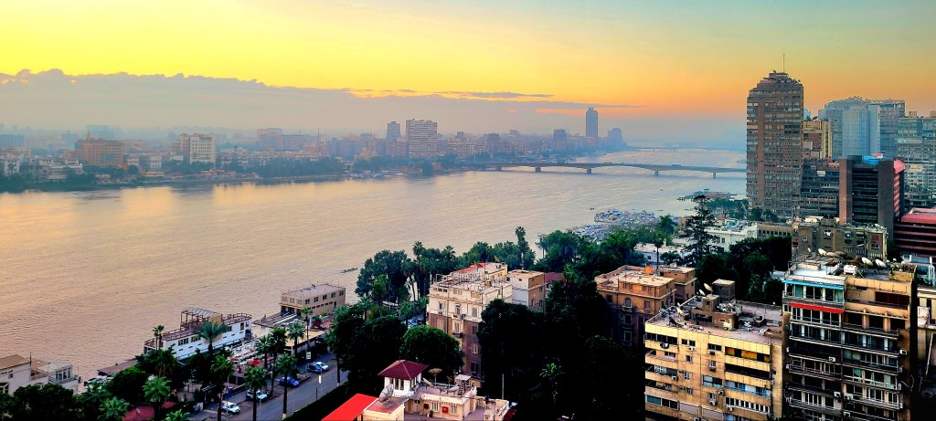
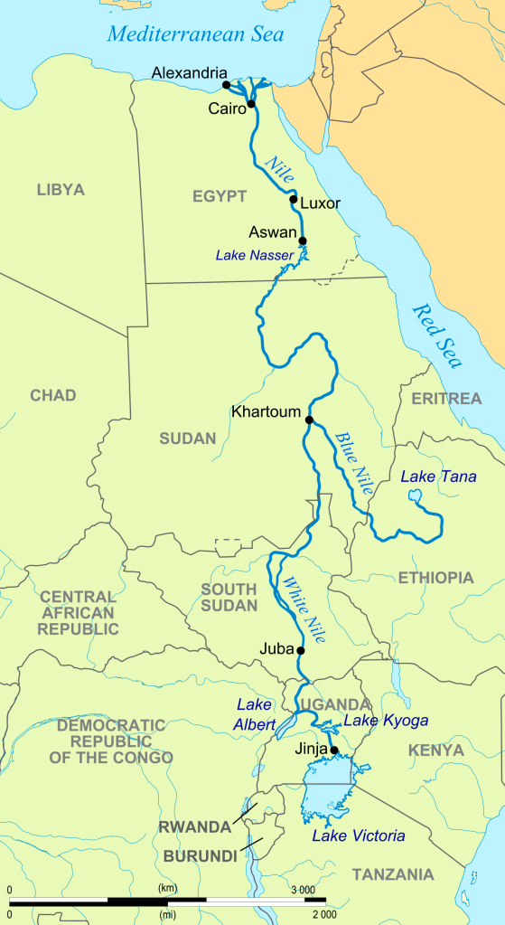
Egypt has relied on the Nile since the dawn of civilization. For over 5000 years, the Nile has pushed nutrient-rich silt through its 6600-km waterway from the wellsprings of Lake Tana in Ethiopia (Blue Nile) and Lake Victoria in Uganda (White Nile), on its way through Cairo, where it eventually runs across the delta and drains into the Mediterranean.

Just as the Nile shaped the landscape, it also shaped a society that believed in the Nile’s magical properties. Ancient Egyptians believed that gods controlled the Nile. They venerated Sobek, the crocodile god who created the Nile,

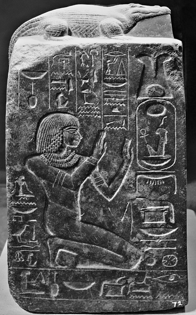
and prayed to Khnum–lord of the water–who fertilized the river banks, thus enabling Hapi, the goddess of ‘Annual Flooding’ to enrich and irrigate Egyptian crops.

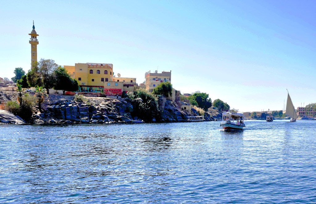
Pharaohs used the Nile as a transit zone for long-hauling building supplies between coastal cities, and establishing monuments to the gods and themselves along the way, like the temple of Kalabsha in Nubia.

Even Aga Khan thought the bank of the Nile was a good idea for a Fatimid mausoleum.

Yet the river that once placed Egypt at the center of the civilized world for 3 millennia is now on life support, and poses a serious threat to the welfare of Egypt’s agriculture, aquaculture, and transportation sectors.

Unfortunately, the matter has been complicated by issues that stem from Egypt’s internal struggles, while the nation also battles other problems originating from south of the border.

For one, Egypt’s population already exceeds 110M, and is projected to swell to 121M in 2030, 160M in 2050, and 225M in 2100.

Egypt’s alarming growth rate over the past millennium has placed the country in economic jeopardy for the foreseeable future. Presently, nearly one-third of the country lives in poverty.

Additionally, with 97% of a dependent population living along the banks of the Nile and its delta, the existential threat to the river Nile has heightened significantly.

Intervention by Egypt over time has resulted in benefits and new challenges…

By partnering with the Soviets between 1960 and 1970,

Soviet-Egypt Friendship Monument

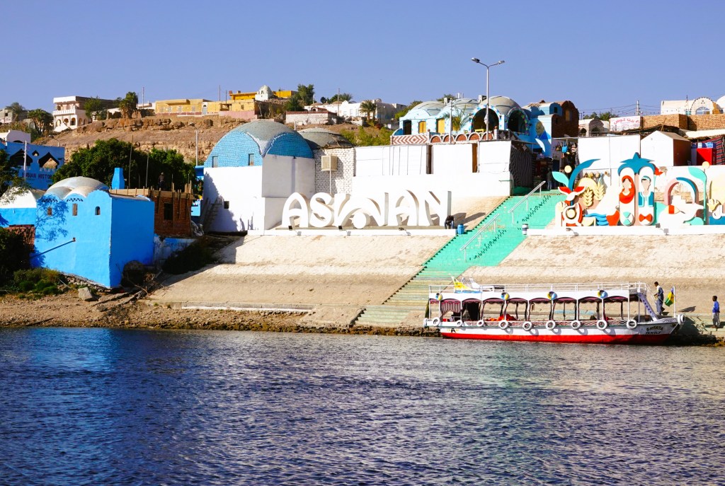
Egypt constructed the Aswan High Dam–an immense embankment dam–upriver from the original Aswan Dam completed by the British in 1902.

It’s purpose: to control flooding;

provide increased water storage for irrigation;

generate hydropower;

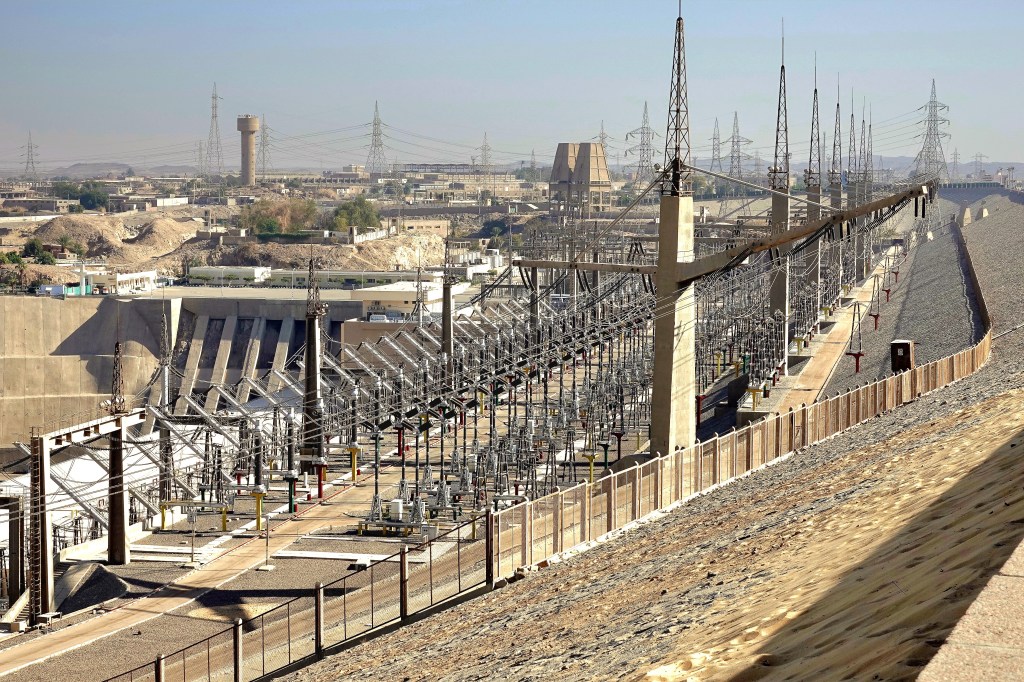
and encourage tourism–all seen as pivotal to Egypt’s industrialization.

Yet, there have been unintended environmental consequences to damming the Nile:

  • The dam restricts passage of rich volcanic sediment that once swept along the entire riverbed, but now struggles to reach the Mediterranean.
  • The Nile Delta has lost a substantial amount of arable land due to the Nile’s inability to provide an unabated flow rate to defeat a rising sea.
  • A 15 cm rise in the Mediterranean’s sea-level over the past century is expected to double over the next 30 years from climate change.
  • To compensate for the salination of the soil, farmers must pump more fresh water from the Nile onto their crops, causing additional pollution from synthetic fertilizer runoff.

According to the Intergovernmental Panel on Climate Change, the U.N.’s group of climate scientists predict the impact on the Nile will be catastrophic. They say it will lose 70% of its flow by the end of the century, with the water supply plummeting to a third of its present capacity.

Good for camels, but not for human survival.

Egyptian officials have also been wrangling over water rights and diplomacy with Ethiopian counterparts, arguing that their water security has been irreparably compromised.

However, more than half of Ethiopia’s 110 million people currently live in the dark. Their leadership is hopeful that the Grand Ethiopian Renaissance Dam on the Blue Nile (begun in 2011) will help to electrify the country and generate power for export.

Consequently, the Renaissance Reservoir will cause a 25% loss of hydropower generated by the Aswan High Dam, a reduction in Lake Nasser’s water retention, and a reduction to Egypt’s flow rate by as much as 25%.

With anticipated droughts in East Africa, a 2oC rise in temperature across the region, and a population crisis that begets increased poverty, it’s imperative that competing countries begin cooperating with each other to protect their citizens and their mutual interests.

Hiking a Shrinking Glacier

There is a glacier lagoon at the tip of Sólheimajökull’s tongue that never existed a decade ago. Today, that lagoon is 80 meters deep, and its fed by glacial melt.

Sólheimajökull is an 11km outlet glacier of Mýrdalsjökull, Iceland’s 4th largest ice cap of 269 named glaciers, and easily accessible and suitable for ice adventuring.

Climatologists have been studying Sólheimajökull’s since 1930, documenting a loss of more than 2 sq.km. of its ablation area, and retreating a mile from its original marker.

During the summer Sólheimajökull loses 3 meters of ice every month with frequent ice calving.

With so much chatter about climate change and glacier volatility, I thought it best to have a look around the ice and judge for myself. So Leah and I drove to Sólheimajökull to join a guided glacier expedition,

where we were outfitted with a harness, helmet, crampons and ice pick. With some instruction, we learned how to dress ourselves and behave like mountaineers.

Then the conversation shifted to safety first, and how to avoid the treacherous crevasses on a melting ice mountain that’s constantly in motion.

After a brief hike, we arrived at the ice, but the approach to the top wasn’t a graduated trail; it was a wall.

Suddenly, I felt our training was insufficient, and I couldn’t imagine that all of us were prepared to dig in with our crampons and ice axes and climb over this wall, but that was unnecessary. We simply stepped around the mound on chiseled risers that were rapidly melting…

until we all reached flat ice.

I questioned why this ice had a different color and texture–more like ice coal–than blue crystal.

Valerio, our guide from northern Italy attributed it to the 1918 eruption of Katla, Iceland’s largest active volcano, and fragments of rock and debris–known as glacial till–that typically develop when a glacier passes over bedrock. We were walking on 100-year ice dated by the volcanic ash trapped inside the ice!

Except for occasional photo ops like a discovered ice cave,

we were always moving across the ice and up the throat, and discouraged from breaking the line or falling behind.

After 30 minutes on the ice, it was time to celebrate with a drink. Valerio grabbed his New Zealand ice ax to tap a vein under the ice, and the bar was open…

and it was cold and refreshing!

Since 1890, Iceland has lost approximately 18% of its ice mass to warming, and Sólheimajökull is melting faster than scientists originally speculated. They are sounding the alarm–telling us that Iceland’s glaciers are melting faster than they can recover.

And climate change, of course, plays a pivotal role in this process. Ironically, eco-tourists are rushing to Iceland to experience the glaciers before they disappear.

But Iceland is doing something to mitigate the damage by pledging carbon-neutrality before 2040. Already, the island’s geography and geology provide almost 100% renewable energy for generating heat and electricity.

But will it be enough for future generations?…

Helsinki–Church of the Rock

With our Norway cruise behind us, Leah and I had designs on extending our Northern European adventure. Unfortunately, our plan to visit St. Petersburg hit a fatal snag after we neglected to apply for Russian visas in a timely fashion.

Originally, our flight from Bergen to St. Peterburg required a transfer through Helsinki, so Helsinki became our default destination for the next four days. Although my dream of touring the Winter Palace and Hermitage was temporarily dashed, Helsinki seemed like a worthy safety net and exciting city to explore.

But something about Helsinki was off. Ordinarily, Helsinki during winter months would be blanketed in snow with the harbor frozen over…

overview in snow

but during our visit, the landscape was fully thawed.

overview with no snow

In fact, residents hadn’t seen a trace of snow since winter’s arrival, although they were experiencing one of the wettest and gloomiest seasons on record.

And that’s exactly how it felt to us as we wandered through Helsinki’s city streets, taking in the cultural setting and the vibe.

On our first day of touring, the rain and wind was relentless, but we were undeterred. In the end, we punished our umbrellas, and rendered them useless. But they saved us from a soaking and protected my camera as we found our way to Helsinki’s 50-year old landmark, the Church of the Rock–

Entrance (2)

embedded in bedrock,

aerial

and capped by an oval dome of skylights and copper.

atop the rock

In 1961, Timo and Tuomo Suomalainen–Finnish brothers and architects–conceptualized a church excavated from solid rock amidst Helsinki’s Töölö district, and were awarded the commission by a jury of their peers.

overview

Ultimately, budget constraints and construction delays prevented the project from getting underway until February 1968, but the brothers saw their vision consecrated in September 1969.

altar

The church became an instant mecca for concerts,

organ (2)

after sound engineers determined that exposing the rough-hewn rock walls could deliver an acoustic nirvana.

candle sconce

More than half a million visitors a year flock to Church of the Rock for worship, wedding celebrations, and meditation.

Leah (2)

But I came to dry off and stare at the ceiling.

flying saucer