Supreme Ruler of Beers

Growing up, I was never much of a beer drinker. But on the odd occasion that my underaged friends and I would sneak a beer in the woods by our homes, it was always an Iron City beer, ’cause that’s what Pirate fans drank in Pittsburgh. Besides, it was high treason to drink anything other than Iron City, and still be part of the cool kids’ club.

Had I been born in St. Louis, I’m certain that things would have gone differently. I’d be a Cardinals fan, and my “go-to” beverage would be Budweiser from the beginning, because Budweiser beer, introduced in 1876 by Aldolphus Busch dominated the St. Louis market, on its way to becoming the first national brand in America, thanks to pasteurization and a fleet of refrigerated rail cars.

In 2008, Anheuser-Busch (A-B) succumbed to a $52 billion hostile takeover by Belgium-Brazillian company InBev to become the world’s largest brewer, and cemented its global stronghold by merging with its rival, London-based SABMiller one year ago for $100 billion.

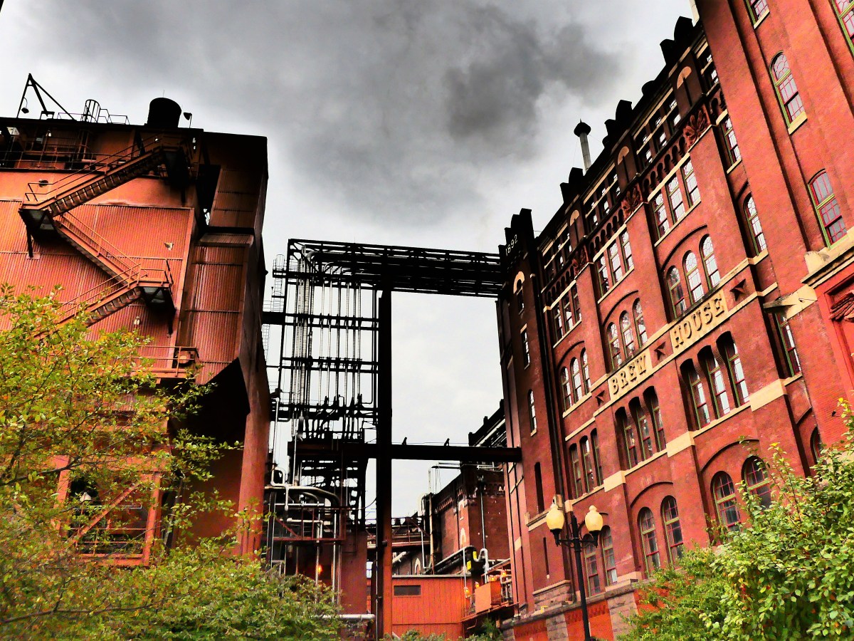
North American operations remain headquartered in St. Louis, where tours are  conducted regularly for beer aficionados interested in A-B’s time-honored brewing process, and for history buffs who appreciate the architecture and design that’s been selected by the National Register as Historic Landmarks.

stained glass

Leah and I arrived at Lynch St. for the 45-minute tour beginning at 3:10 pm. Upon entering the corporate complex, we were surrounded by tall Romanesque red brick buildings with elaborate flourishes and embellishments.

Beer House1

We entered the Welcome Center,

welcome center

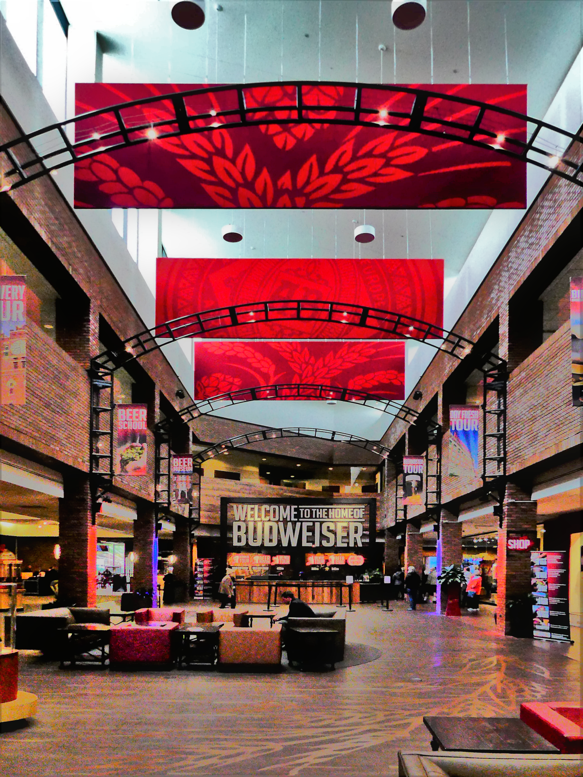
designed to house its branded gift store, pub space, and exhibits.

A-B story

Soon after, we were introduced to our assigned tour guides, Tim and Andrew who spoke about sticking together amid the tight security surrounding the campus, before ushering our group of fifty outdoors to gawk at the Clydesdales in the exercise yard.

Clydesdale posing

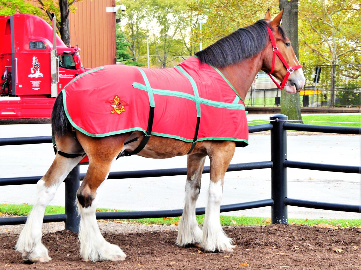
These massive draught horses stand at 18 hands, and have been carefully bred by the brewery to retain their chestnut coloring and markings, making them the most identifiable mascot in beer branding and advertising.

From there, it was a short stroll to the Carriage House where we were split into two groups: those on a steamboat cruise stuck with Andrew, while the rest of us walk-ins aligned with Tim, a self-professed expert on all things beer, who dared to be challenged with any questions on Anheuser Busch.

After moving to Washington, DC to attend college, my beer drinking habits matured. Staying true to my roots, Iron City was quickly replaced by Rolling Rock, a more “premium” beer with a smoother taste in a green bottle imported from Latrobe, PA.

Once inside the Carriage House, we were introduced to Murry, who was being braided for the 3:30 pm parade.

grooming (2)

ready for parade

A peek inside the paddock, showed it to be far cleaner and neater than many major hotel chains across the country.

Harness room

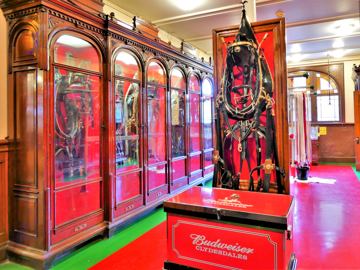
In fact, the art-deco structure gleamed from ceiling…

carriage house ceiling

…to floor with nary a strand of straw out of place.

paddock

And that’s when things went awry. Returning to the carriage room, I noticed that everyone had left the building.

carriage room (3)

Running through the exit doors, I caught a glimpse of Leah up ahead and hurried to her side, only to realize once we returned to the Welcome Center, that she had followed the wrong group. We scrambled around outside to find Tim’s tour, but after pulling on a few secured doors, and with no one in sight, we were hopelessly lost.

Back at the Welcome Center, we approached a tour concierge to confess our situation.

“Not a problem!” she addressed. “Follow me!”

We backtracked to our last stop, before she led us into a building showcasing immense tankards–each one capable of Beechwood aging 3600 barrels of beer at a time.

Beechwood aging tanks

We continued our personal tour until we eventually rejoined Tim in an elaborate Tasting Room…

Tasting Room art

…during his lecture on the ingredients and the brewing process,

brewing process

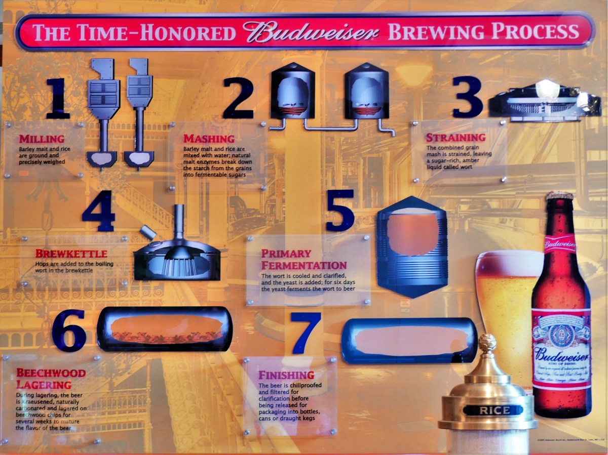
while everyone sipped on a 6 oz. portion of chilled Budweiser.

A wacky summer abroad between my sophomore and junior year enlightened and refined my taste in beer, having sampled Grolsch in Enschede, Kronenbourg in Strasbourg, Carlsbad in Copenhagen, and Hafbrau in Bavaria. I loved them all.

But I must admit, that after finding our way back to the tour, my little cup of Bud tasted mighty refreshing.

The twenty-five of us rode the elevator up to the Mash House. The moment the doors closed the Bud jingle sounded.

“Do you know the composer’s name,” I inquired.

Without even thinking, Tim responded as the elevator doors reopened, “Steve Karmen, who also wrote the ‘I Love New York’ jingle.”

We spread out across the ornate wrought iron railing to take in the scene. No doubt, the Mash Tanks were impressive.

Mash House

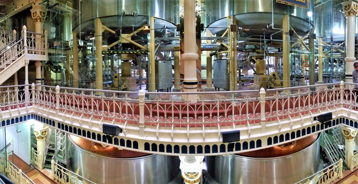
And three hop vine chandeliers from the 1904 Worlds Fair were dangling from the five-story ceiling.

hops lite

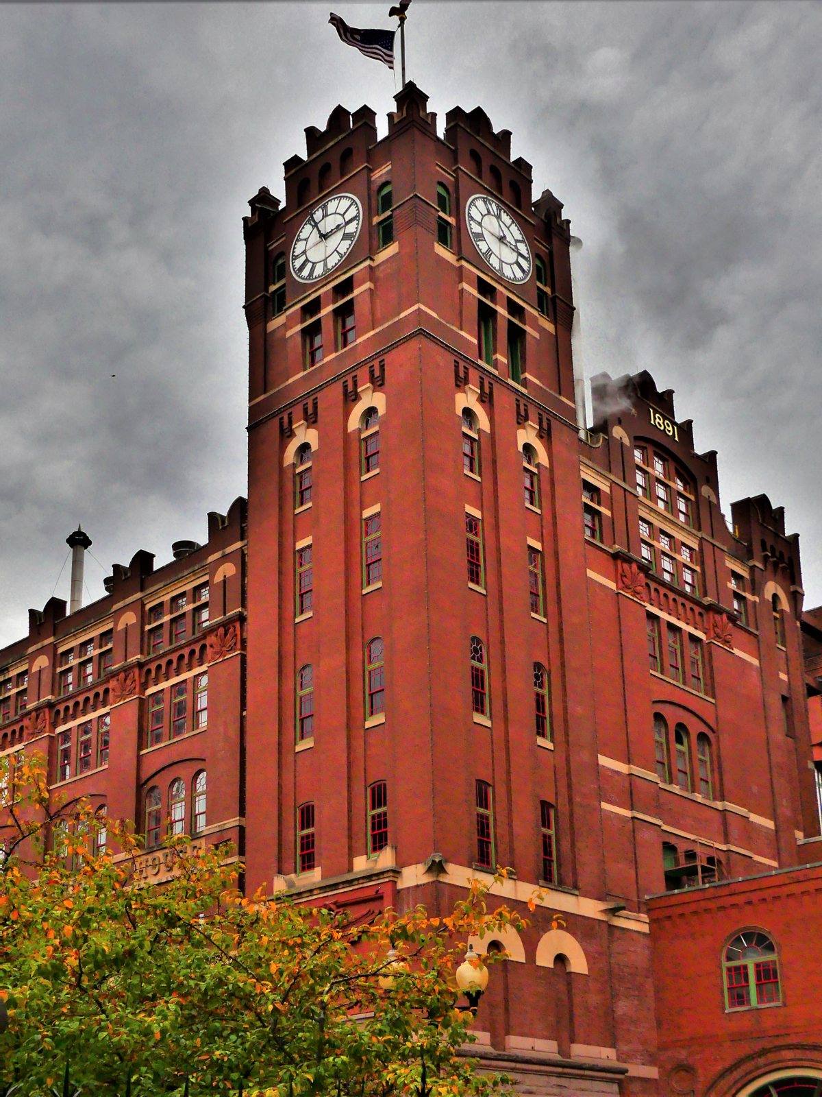
Then it was outdoors again, this time near the clock tower–the second most photographed structure in St. Louis–

clock tower

where Tim revealed that business as usual during Prohibition years depended on the sale of Brewers yeast and a non-alcoholic malt beverage concoction.

“Any last questions?” intoned Tim.

I glanced at my watch, and true to form, it was 3:55 pm. We were precisely at the 45-minute mark, but something wasn’t right. I pointed to the tower, and got Tim’s attention. Here was my last chance to stump Tim.

“Hey Tim, did I miss daylight savings time, or did the clock master just get ahead of himself?” I surmised.

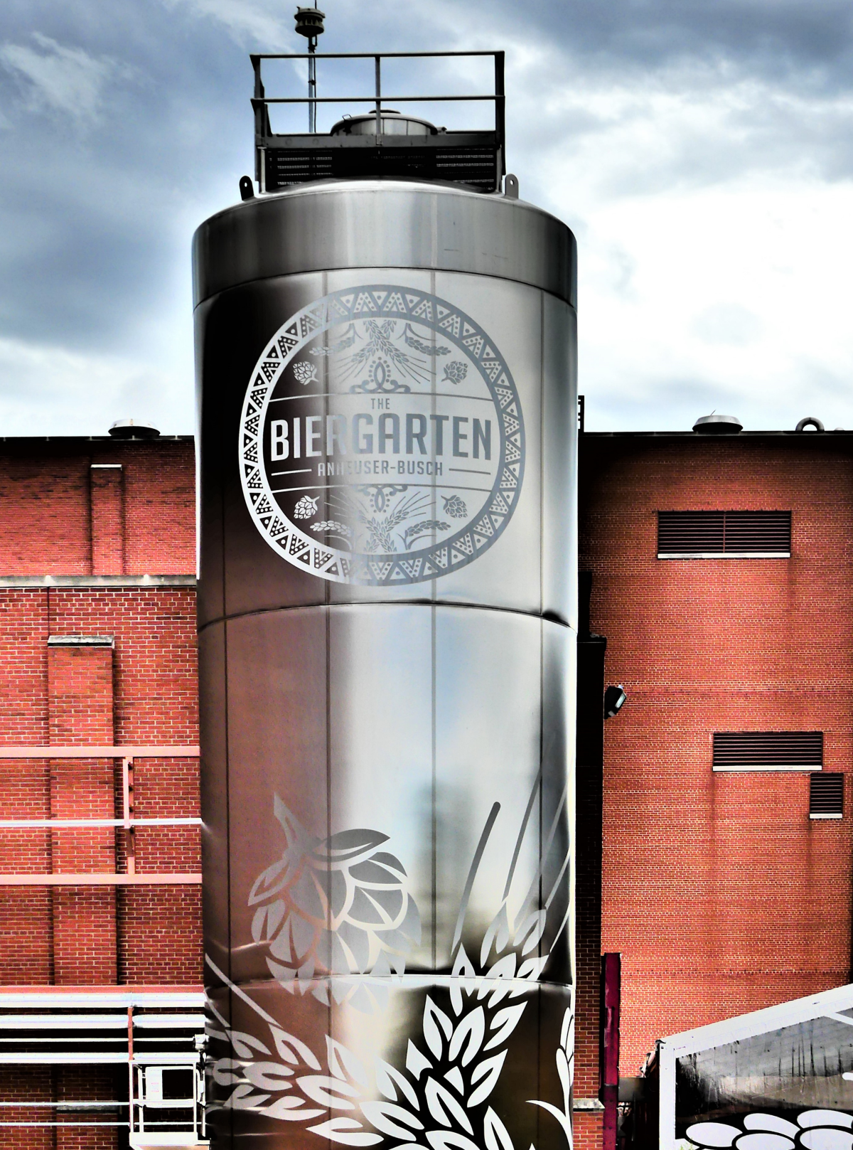
Tim looked at the tower clock and hesitated. “Well let’s see a minute. The clocks get turned back this weekend, so I’m pretty sure it’s been set in anticipation of the event… Well, that concludes our tour today. However, the best is yet to come, since we’ll now return to the Biergarten where you can redeem your wood token for a ‘cold one’.”

Biergarten

I lingered behind. I wanted another shot of the clock tower.

tower and eagle1 (2)

I finally caught up to Leah inside the Welcome Center, where deep lines had already formed in front of the bar. But another station beyond the crowd had fewer people standing, so that’s where we went. To my surprise, the bartender was drawing Stella into familiar chalices from the tap–my newest favorite, and one of A-B’s newest brands since last year’s merger.

I ran into Tim on my way to an available high-top.

“Quick question, Tim! What’s the significance of the ’33’ on the Rolling Rock bottle?”

“I get that question a lot,” he began, and rattled off, “Rolling Rock – from the glass lined tanks of Old Latrobe, we tender this premium beer for your enjoyment as a tribute to your good taste. It comes from the mountain springs to you.”

Tim was the real deal, and so was my Stella.

P.S. When editing photographs for this post, I compared the meta-data between the clock tower shots. Even though the two were taken 5 minutes apart, the times on the clock were exactly the same. Final analysis: THE CLOCK IS BROKEN!


American Kitsch

Years ago, Dennis Miller–when he was funny–referred to Branson, Missouri as Las Vegas for people without teeth. Twenty years later, Miller’s revelation still hits the mark, despite the advent of implants and veneers.

While attending a sold-out concert featuring the Oak Ridge Boys at the Mansion Theater,

Oak Ridge Boys1 (2)

it was hard not to notice the adoration of a graying audience. Women wearing shades of autumn-colored hair to complement their leopard print outfits seemed to swoon through an earnest and sincere set of gospel-laced ballads and patriotic country-swing tunes, while their stoic significant others, coiffed in their stiff anywhere/anytime cowboy hats, eventually removed them, perhaps taking a cue from William Lee Golden during his performance.

‎ORB William Lee Golden

Upon returning to the parking lot after the show, we noticed how haphazardly most vehicles were parked, with little regard for lane assignments. It could have been a freeze frame from a demolition derby. Few could recall where they parked their trucks or SUVs, so collectively pressing the alarm buttons on their keys produced a cacophony of blaring horns and flashing headlights that continued to frustrate a clueless crowd.

Of course, things are no better on the roads. The yellow, blue and red routes always appear to be congested, because drivers can’t get out of their own way, and nobody knows where they’re going. Unfortunately, turn signals are no more than car decoration.

Or maybe the sites on the edge of the road are so compelling that traffic snarls are to be expected.

What follows is a sampling of some of the roadside attractions that caught my attention.

ferris wheel

fork and meatball

King Kong

plane

Titanic

Ripley's

chicken dinner

P.S. We found our truck in the Mansion lot, and found our way back to the Airstream, but it took forty minutes to travel four miles.


Poetry in Motion

Amazing Acrobats of Shanghai and their rival, Acrobats of China compete daily for the attention of visitors in an already crowded field of Branson venues showcasing music and variety entertainment. The two maintain similar visions–featuring acts displaying power, balance and artistry. But because one theater was closer to the Airstream than the other, and with available seats closer to the stage, and for a few dollars less, Leah and I chose the Shanghai troupe for our evening out on the town.

We arrived during a warm-up act with two costumed chickens made of paper, and a clown blowing a whistle. The sparse crowd was disinterested, generating a smattering of applause.

The theater was dingy and the seat cushions had lost their springs many summers ago. It was the first freeze of the season, and the concrete floor was sending chills through the soles of my shoes. It made me check my watch, and wonder how much longer we would be here.

By the time the lights had dimmed and the curtain pulled, the audience and I were hoping to be amazed.

This was NOT Cirque du Soliel: the set design featured a lit cyclorama and necessary props on a short and shallow stage; the costumes were functional and simple (with the exception of traditional animal puppets); and the music track was borrowed from a Chinese elevator.

But the young acrobats, mostly in their mid-twenties, were enthusiastic performers with towering talents,

chair tower

and well-rounded abilities–demonstrating precision and grace throughout their respective routines.

Thematically, the acts seemed to showcase a variety of spinning stunts. Around and around went the table, hoops, and vases.

circle and square before

circle and square

hoops before

Hoops after

Around and around whirled the ninjas in their karate sequences, and the aerialists in their pas de deux.

butterfly

spinning

Around and around, the contortionist twisted her body into wincing pretzel postures.

contorting

contorted

When the show ended to rousing applause, Leah and I crossed the lobby to inspect an easel of audience portraits stuffed inside commemorative frames with plenty of room for acrobat autographs…and available for purchase at only $20 a piece.

While we enjoyed the show, we quickly decided against sticking around for the  meet and greet, as the acrobats lined up to express their gratitude, but seemed more uncomfortable with both feet firmly planted on the ground.

Eureka!

A stopover in Eureka Springs, AR along the way to Branson, MO produced some Eureka! moments and other assorted revelations.

For one, there are seventeen registered churches in Eureka Springs, ministering to two thousand healing hearts and souls around town, plus a Tibetan Buddhist temple and an integrated monastery of celibate brothers and sisters.

Religious overtones are also pervasive throughout town. Our Airstream was parked along Passion Play Rd., above the hallowed hollow where The Great Passion Play’s dramatic reenactment of the last week of Jesus Christ is the #1 tourist attraction in the area, and The Christ of the Ozarks rises nearby, hovering above the dense woods of Magnetic Mountain.

Jesus of the Ozarks

Christ sign

Big Jesus side view

Also looking down from town, the Crescent Hotel–recently added to the National Register of Historic Places–delivers luxurious living and salon services, in what’s billed as America’s Most Haunted Hotel.

Historic Crescent Hotel

Crescent Hotel

A fourth-floor lookout…

P1100279

provides familiar views in the distance,

Jesus over sunset

and an overlook of St. Elizabeth Catholic Church of Hungary–listed in Ripley’s Believe It or Not as the only church in America with entry through the bell tower.

St. Elizabeth Church1 (2)

Stunning religious “art-chitecture” can also be found at the Thorncrown Chapel, a jewel of glass and wood tucked into the hillside atop a ledge of flagstone.

Thorncrown Chapel1 (2)

Inside Eureka Springs’ Victorian historical district, the Byzantine-styled First Baptist Church stands at the corner of three intersecting streets with entrances at each of its four levels, giving it four distinct addresses and cause for another Ripley’s entry.

First Baptist Church

The charm of downtown carries through its narrow winding streets, acute corners, and graded roads of 30% or greater, routinely decorated with accents of fine art…

down the street

Steps to Spring St.

…and frivolity.

Humpty Dumpty gnome

horn orchestra (2)

Eureka Springs came by its name naturally, manifesting no less than sixty-two springs that gushed from the mountainside with so-called healing properties. Its establishment as a resort community during the 1870’s prompted visitors from near and far to “take the waters” by drinking up and soaking in its therapeutic juices.

civil war healing

90% cure rate

Today, over a dozen springs have been restored to former glory.

Magnetic Spring plaque

Magnetic Spring

And while the water is no longer potable, the park habitats have given the springs a new lease on life,

Harding Spring

Basin Spring

and have renewed the town’s reputation as a popular healing destination,

Eureka Healing (2)

with an emphasis on preserved charm.

County Courthouse

top floor (2)

ball and house

facade

facades.png

Palace Hotel gazebo

Perhaps the biggest paradox of Eureka Springs would have to be the town’s united commitment to all things ghosts and Halloween, given its adherence and roots in Christiandom, while billing itself as “the place” for the best Halloween party in America…

Grand Central Hotel

Chile Lily

…breathing spiritual relevance into Euripides’ quote: Money is the wise man’s religion.

Sanctuary

Sanctuary comes in many different forms: as a retreat–a place one goes for guidance and inspiration; as a house of worship–a place to seek spiritual healing and nourishment; and as a refuge–a place to escape misuse or abuse. Within 24 hours, Leah and I managed to come across all three in a small corner of mid-western America.

For those searching for faith-based education, Oral Roberts University in Tulsa, OK has a campus fingerprint: Make No Little Plans Here

Make No Little Plans Here

The university’s holistic approach feeds the spirit, mind, and body.

hands1

The university’s futuristic and mid-century modern architecture attributed to Frank Wallace is best appreciated from the flying saucer,

prayer tower

that also passes for an observation deck,

ORU observation deck

and reflection gallery.

OR advice

It’s gold-tinted, anti-glare windows colorize the outward views in a peculiar warm bath of Genesis green.

classroom tower

classroom building

auditorium

campus green

And while folded hands may symbolize a deep connection between God and Christianity,

hands of God

…any university coed would easily characterize the statue as a student praying to pass.


Architecture on a higher plane/plain can be found nearby, in the hills of the Ozarks. While no less spiritual in nature, the Thorncrown Chapel is rooted in nature.

entry

An elaborate composition of wooden trusses embracing 425 windows gives an ethereal nod to a scripture and proverb mash-up of not casting the first stone in glass houses.

From the hillside, the chapel seemingly disappears among the flora,

camouflage

and when juxtaposed to the outdoors, the chapel’s transparency is flaunted by its six thousand square feet of glass.

looking outside in

However, the chapel’s connection to nature shines brighter from within the polished maplewood doors,

interior

where an arboretum of beams reaching forty-eight feet to the clouds…

inside out1

can be contemplated and photographed from a distant pew. (Photography is allowed, but only from a sitting position.)

pews and lights

But Thorncrown Chapel is more than a beautiful building. It’s a celebration of Jim Reed’s spirit and vision, and a noble tribute to the glory of his resignation to a higher power.


Lastly, eleven miles south, on the edge of Eureka Springs, AK, Turpentine Creek Wildlife Refuge provides shelter and care to abandoned, abused, and neglected wildcats, whose owners have miscalculated the cost and trouble of raising and breeding them in captivity.

entrance1

Currently, Turpentine Creek has become a haven to 100 lions, tigers, ligers, and cougars like Nala and Brody.

Natural habitats built with benefactor dollars provide asylum to big cats,

2 tiger habitat

who are now free to live out their lives in a protected environment,

2 tigers

while being offered preventative and emergency medical treatment.

tiger repose

These cats cannot be released into the wild,

tiger habitat

as they’ve lost their ability to fend and defend after being declawed by their owners,

cougar gnawing on cardboard tubing

who in their ignorance and arrogance wished to make them less dangerous to handle as one-time pets.

white tiger

Nevertheless, a cadre of volunteers assists a small staff in feeding, cleaning, examining, and behavior-modifying these beasts. Thus, providing each big cat with a humane existence.

Day-to-day operations are assisted through visitor admissions, gift shop sales, and donations by large corporations like Tyson, who feeds the herd 300,000 lbs. of chicken every year.


Sanctuaries of thought, redemption, and protection offer safe places to learn, to reflect, and retire to. Remove anyone of them, and society faces a danger of turning in on itself, further sewing the sleeves of divisiveness.

Better still, offering asylum to the millions of struggling homeless across the country, and persecuted refugees around the world would improve their safety and dignity, and allow more of humanity to participate in their own recovery.

Palo Duro Canyon Tailwinds

Wouldn’t you know it?! Texas has a Grand Canyon of its own in the middle of its panhandle called Palo Duro. And the best way to see it is from the saddle of a horse while riding at the bottom of the canyon floor.

We’d been wanting to go horseback riding for the past few months, but something always interfered with our plans, or time wouldn’t allow. But Leah was determined.

“If you can ride in a balloon, then I get to ride a horse,” she declared.

And true to her word, reservations made on Thursday got us an early ride time with Jennifer at Old West Stables inside the state park.

stables

stables1 (2)

We mounted Buster and Lloyd,

our ride

and rode along an unmapped equestrian trail that took us along the foothills of the canyon walls…

on the trail2

and through the hills and ravines of a basin carved by the Prairie Dog Town Fork of the Red River over one million years ago.

We passed colorful rock formations resulting from a geologic compression of four distinct periods layered over the course of 250 million years.

canyon wall.jpg

While I enjoyed the scenery, and the quiet of the canyon,

canyon peak

canyon strata

I had the disadvantage of riding behind Leah’s horse, Lloyd.

Leah and Lloyd

Lloyd was a farter who always positioned himself behind the lead horse.

on the trail3

And no matter how many times I tried to hold Buster back…

on the trail4

…we would always find our way back behind Lloyd’s swishing tail,

Buster follows too closely

where Buster was always greeted with a slow and steady current of foul wind, followed by an evacuation.

The hour passed as easily as Lloyd’s breakfast, and we found ourselves back at the stable, in time for Lloyd’s lunch.

back at the ranch

Once finished, we took a ride back to the lodge at the top of the canyon for a better perspective of the second largest canyon system in America,

canyon vista1

overview detail

before returning to the basin’s scenic road to explore the Big Cave,

BC trail

an opening in the red rock that’s not as big as it’s unusual.

cave entrance

cave mouth1

Big Cave inside out

cave opening (2)

The Texas panhandle is as flat as a cowpie, and wide as the open sky.

Airstream sunrise1

Thankfully, Palo Duro Canyon provides some variety to a linear landscape, and adds some color to a pale prairie palette.


Balloonatic

“$450 for a balloon ride?! You’ve got to be kidding” I exclaimed to the Rainbow Ryder rep on the phone.

“That’s the price, sir. We are the exclusive balloon ride provider for Balloon Fiesta, unless you’re willing to fly outside the ‘Albuquerque Box’,” she managed.

“What’s the ‘Albuquerque Box’? I inquired.

“It’s a weather phenomenon peculiar to Albuquerque,” she pointed out, “where the lowest winds move in one direction, while the higher winds are moving in the opposite direction. That way, our pilots can take advantage of the different air currents, by floating higher or lower, and return you close to your original launch point.

albuquerquebox
*courtesy of Drumlineramos

“Uh, Ohh-kay,” I shrugged, “and that’s worth $450?”

“That’s the rate for a balloon ride during Balloon Fiesta, sir. And I only have a few openings left for Saturday and Sunday,” she pitched.

“Your price is sky high,” I offered, “so I’m gonna have to think about it.” And this call was over.

I turned to Leah. “Looks like my balloon ride went from bucket list to “fuck-it” list.”

And that was a drag, since Balloon Fiesta is the largest gathering of hot-air balloons in the world, with more balloons lifting off together (mass ascension) than anywhere else.

Leah sensed my disappointment. “Maybe it’s cheaper if you found an outfitter outside the box. Would you still be interested?

“I think I could manage to get excited,” I lamented.

After a flurry of phoning and pricing, I secured a dawn launch on Saturday for $250 with World Balloon, albeit on the northwest side of town, miles away from the Fiesta.

Launch day bears all the markings for a picture-perfect take-off: early air temperature hovers in the mid-40’s; the wind is streaming from the north at 8 mph; and the sky is clear as shimmering water.

A group of fifty men, women, and children are sub-divided into five, and assigned to a pilot and his balloon crew. Each chase van carries two wranglers, ten passengers, and a trailer packed with gear. We congregate at a barren football-sized lot, and watch as five balloons are prepared for flight.

Baskets are unloaded,

unloading the basket

and assembled.

building the basket

The burners are tested.

testing the burner

With dawn breaking over the horizon, the balloon is unfurled, and rigged to the basket.

rigging the lines

An industrial fan blows cold air into the mouth of limp polyester, and behold, the balloon takes shape.

dawn

raising the dome

filling the balloons

Roy aims the burner flame into the mouth to heat the air,

lighting it up

fire and rigging

and eventually expands the envelope to fullness.

inflation

The buoyant balloon rights itself,

sunrise

and the six of us scramble inside to bid adieu to terra firma, and gently float away…

aloft

…one step ahead of a second balloon.

balloon sun glow

All the while, balloons below…

balloon party

…are preparing to follow our Airstream (wink wink, nod nod).

USA balloons

Our pilot, Roy pulls on the burners,

Roy the pilot

carrying us to 5000 ft. above the treetops,

fiesta panorama

where a birds-eye view of the valley below,

self portrait.jpg

reveals a cityscape punctuated by fantastic dots of floating colors.

Balloons over Albuquerque (2)

Yet closer inspection reveals the full dimension of a multi-colored mushroom gliding through an azure sky.

baloon portrait

After forty-five minutes of soaring and dipping through neighborhoods–arousing excitable dogs,

annoyed dogs

and adoring children–

delighted-children.jpg

Roy is tasked with finding a landing site along our flight path–wide open and away from wires–and accessible to the chase team who’s been following us since our launch. After a few false starts, we locate a large house devoid of landscaping, and gently settle back to earth.

attempting to land (2)

However, a chain-link fence lines the perimeter, and a locked gate gives us no way out. A woman from Birmingham, AL vaults over the side of the basket and runs to the front door to alert the owners to unlock the gate, but nobody’s home.

So it’s back in the air, with the van in pursuit, until we mobilize at a strip mall.

landing place

crew pulling us in

After a quick exchange of passengers (six out and four in), our balloon is re-released with its second set of aeronauts,

group 2 on board

drifting higher into the blue yonder.

group 2 aloft

Fifty minutes later, the vacant parking lot beside the church provides the perfect setting for a second re-entry.

holy touchdown

Whereupon, the balloon is quickly collapsed,

gathering air

and folded,

wrangling the rigging

and packed away, until next time.

wrapped up

Back at base camp, it was time for a champagne toast, and a recitation of the balloonist’s prayer:

The winds…

flight certificate

I loved it, and I’d do it again. I guess that makes me a balloonatic.


Western Decivilization

It was late afternoon, golden hour, and the town was aglow. We rolled into Tombstone, AZ with the tumbleweeds, and got out of town by morning, but not before taking a sun-soaked stroll down Allen Street past the O.K. Corral, tracing the footsteps of a by-gone time.

wagon (3).jpg

The Old West town was unusually quiet this day,

boardwalk

as if its residents were hiding out, bracing for yet another round of random violence, when claim jumpers, cattle rustlers, horse thieves, prostitutes, and gamblers challenged the moral fiber of a nascent society teetering between greatness and greed.

Despite the fear, there were some who dared to venture out…

Allen Street

and walk the dusty planks of a fragile peace, with their trusty sidearms at the ready.

local color (2).jpg

Yet it was business as usual at the Bird Cage Theatre,

birdcage theatre

where wanton women plied their trade at twenty-three bucks a pop,

27-01.jpg

in their boudoir quarters…

dressing room

boudoir

…beyond the catwalk over the saloon,

catwalk

while high-stakes poker flourished under the stage,

stage curtain

with a $1000 minimum buy-in.

poker table.jpg

But outside on the street, trouble was brewing.

Slide 1.jpg
The Earps had heard that “The Cowboys” were gathering at the O.K. Corral making threats and spoiling for a fight.
Slide 2.jpg
Rounding the corner of 4th and Freemont, the Earps headed west to the rear entrance of the O.K. Corral for a date with destiny.
Slide 3.jpg
When the fight begins, Town Marshal Virgil Earp (with cane) says “Hold on, we don’t want that,” as Frank McLowery and Billy Clanton take the first bullets from Doc and Morgan.
Slide 4.jpg
Billy Clanton (2nd from right) draws his gun and begins to fire back as his brother Ike begs Wyatt Earp not to shoot him. Morgan and Doc are concentrating on Frank McLowery and the game Billy Clanton who, though mortally wounded, continues to shoot. Frank and Tom maneuver their horses as shields.
Slide 5.jpg
As Ike Clanton flees, Virgil Earp and Tom McLowery bring their guns into action. Doc Holiday turns to fire at the fleeing Ike, while Morgan continues to fire at the wounded Frank McLowery.
Slide 6.jpg
Frank McLowery maneuvers his horse into the street and fires back under the horse’s neck as Holliday pulls a sawed-off shotgun from under his coat. An anonymous shot, possibly from Billy Claiborne is fired from within the O.K. Corral, diverting the Earps’ attention.
Slide 7.jpg
Frank McLowery still manages to hang onto his horse for cover as his brother Tom, shooting over his saddle, hits Morgan Earp. Billy Clayton (nearing death) returns fire at Virgil and Wyatt. A shot from Frank hits Marshal Virgil Earp in the right leg.
103742_0.jpg
Thirty bullets are fired in a thirty second outburst. When the smoke clears, Billy Clanton and both McLaury brothers lay dead in the street. Ike Clanton, claiming that he was unarmed has run from the fight, along with Billy Claiborne. Virgil, Morgan, and Doc Holliday are wounded, but Wyatt Earp is unharmed.

Certainly, death was big business for the Tombstone Undertakers.

coffin ad (2).jpg

funeral carriage

And on occasion, death was high entertainment for the townsfolk.

invitation to a hanging

Cochise County Court House

courthouse gallows

hanging noose

standing coffin

mission bell

And as the sun sets on Tombstone…

sunset over tombstone (2)

we remember the lawlessness of the Wild, Wild West,

City Hall

but we celebrate the triumph of a Town Too Tough to Die…

old town set

…a worthy consideration while we soaked away the stress in a hot spring along the Rio Grande the following day in Truth or Consequences, NM.

morning soak by the rio grande .jpg


Milestones

What started out as an intimate blog intended for sharing our cross-country adventures with family and friends has taken on higher meaning and greater dimension. After seven months of 100 posts, 10,000 views, 4000 visitors from over 150 countries, and a new family of nearly 1000 followers, this blog has eclipsed all that I could have imagined.

It has changed how I look through a lens and how I craft a story. It has transformed my posts from informative to entertaining. The discipline has made me a more fluent writer and sharper photographer, for which I am thankful.

Your collective thoughts and comments are a driving force to improve my content, and I am grateful for the feedback and acknowledgement.

I’d like to think that this evolution and subsequent statistics are because of my new and loyal audience, and I thank you dearly.

Additionally, my apologies to Leah, who must now contend with my newest obsession.

Nature Under Glass

Exploring Tucson, AZ provided two very different opportunities to experience nature–Saguaro National Park and Biosphere 2–with one generating more interest than the other.

We reserved a site at Catalina State Park’s campground…

Catalina Mtns

to be equidistant between the two National Park districts: Rincon Mountain (RMD-east) and Tucson Mountain (TMD-west). Why two districts? In the 1960’s, concern over RMD’s cactus forest showing a decline in new growth, prompted conservationists to acquire a stand of ancient saguaros to the west of Tucson, separating the two districts by an hour’s drive.

Leah and I began our journey at TMD, at first, through a meandering exurban road that eventually led to an unpaved, rutted, and narrow scenic Bajada loop drive covering five miles of Tuscon Mountain foothills. A stop at the Desert Discovery Trail brought us within no touching distance of magnificent saguaro cacti measuring over thirty feet tall.

key light saguaro (2)

Each specimen appears unique, sprouting limbs in different places, and contorting in all directions,

desertscape (2)

giving relevance to Native American claims that these are people standing among the sand and rocks.

Desert Trail

Their petroglyphs across Signal Hill are a testament to their long-standing occupation of the territory more than one thousand years ago.

petroglyph and mountain1

signal hill petroglyphs

A memorable hike along the Valley View Trail slowly ascends a ridge, offering dramatic views of Avra Valley’s saguaro-sprawl, with Picachu Peak in the distance.

Avra Valley and Picacho Peak

With temperatures reaching into the high 90’s, we avoided all other trails–requiring a minimum of three to four hours of dedicated strain–in favor of cross-town traffic delays that minimized our allotted time to visit RMD.

Once at the eastern park gate, we roamed the paved eight-mile Cactus Forest Drive, switch-backing into higher elevations, with warm western sun casting a golden hue across the desert, turning a forbidding vista…


mtn garden and sky

into an inviting playground,

western sun across the desert

protected by a standing legion of cactus totems.

rincon mtns


The following day, we turned our attention to an experiment in the remote reaches of the Sonoran Desert,

setting

originally conceived in 1984 to “research and develop self-sustaining space-colonization technology,” and leading to two highly publicized missions between 1991 and 1994–where teams of eight were sealed into a self-sustaining environment for two-year terms and monitored for their “survivability”. Scientists named it Biosphere 2.

establishing

bioscape

rincon range

landscaping

Presently, the University of Arizona has assumed stewardship of the facility, turning its focus toward research on climate change–mimicking diverse ecosystems, such as the ocean,

ocean habitat

the rainforest,

rain forest

and coastal fog desert,

desert habitat

all managed under controlled conditions.

Beneath nature’s museum lies the technosphere, a myriad of pipes and wiring,

recycled air conditioning

channels and ducts, tubes and cables, and other facilities necessary for vital operation.

An ingenious dome-shaped lung…

lung

connected to the glass enclosure by tunnels…

tunnel

allows for air expansion caused by ever-changing pressures within the sealed structure.

The scope of the facility is a marvel, boasting double redundancy for all power and life support systems.

power supplies

A common question on the tour, “Why is it called Biosphere 2? Was there another Biosphere before this one?”

The docent is keen to respond, “Yes. Another Biosphere exists, where random, haphazard and uncontrolled experiments called living are carried out on a daily basis, but we commonly refer to it as Earth.”


Putting Leah in Perspective

Picasso painted Marie-Thérèse Walter and Dora Maar among others; Dali’s choice was Gala; and Stieglitz extensively photographed Georgia O’Keeffe. The results of these collaborations are legendary. Artists have always depended on models…for inspiration, as subjects, as lovers.

fallen tree (2)

And while I eschew classifying myself as an artist, my reliance on Leah in my landscape photographs is no different than the aforementioned masters…with one exception: scale!

burned out but alive (2)

Often times during picture editing, she will lament, “Why am I so small? You can hardly see me!”

Rainbow Trail panorama (2)

But being able to insert Leah into a panoramic scene or long shot helps me establish dimension and grandiosity.

Leah F150 formation (2)

And while there are times when I seemingly wait forever for someone to step outside the frame of my shot before pressing the shutter, there are also times when it becomes vital to locate Leah in my scene to anchor its meaningfulness, and increase its effectiveness.

Prairie grass and Leah (2)

Sometimes Leah can be an unwilling participant. She may object if she feels she’s not looking her best, or perhaps she becomes annoyed if she’s not the central focus of my photograph when she feels like posing.

Leah (2)

But either way, she has always been a good sport, and is usually compliant when taking my directions.

waders vertical (2)

But regardless of how many rocks she leans against per my request, it’s evident to me, photography aside, how much I lean on her.

canyon shade

She is my personal rock, who helps me put things in perspective.

balance rock and leah (2)

via Photo Challenge: Scale

Sleepless in Las Vegas

Seldom am I so amazed that I am speechless or at a loss for words…

After visiting twenty-nine U.S. National Parks, four Canadian National Parks, a dozen National Monuments, numerous State and Provincial Parks, and driving thousands of miles of scenic byways over the past twenty-nine weeks,

captured on:

Leah and I have yet to discover a place that is so captivating that we didn’t want to leave…until now.

Rainbow Trail panorama (2)
Leah and me

Valley of Fire State Park allowed us the chance to finally exhale, after America held its collective breath trying to make sense of yet another senseless killing spree, when a maniacal sniper opened fire on a crowd of 20,000 innocents a ¼-mile away.

We were 4½ miles out of harm’s way, staying at an RV resort off I-15 at the time, and wondered about the incessant sirens screaming past our open windows after 10 pm that fateful evening..

“I can’t believe how much crime they have here,” Leah exclaimed.

“Wouldn’t want to live here,” I offered.

Switching on the TV, all stations were locked on breaking news of an active shooter at the strip, but details were sketchy with the story developing by the minute. We quickly realized that we were listening to the soundtrack of a massacre: SWAT teams, police, EMT, and ambulances were sprinting past our Airstream–in and out of the danger zone.

Originally, we booked a couple of days in Vegas to decompress, and intended on exploring the strip in search of available show tickets once the Airstream was unhitched. But the prospects of casino crawling quickly faded after an afternoon of relaxation by the pool. Then again, we figured there would always be tomorrow.

Yet by morning, as the tragedy at Mandalay Bay unfolded, the thought of unthinkable loss left us gasping for air.

Leah summed it up: “It doesn’t feel right having fun when we’re surrounded by so much pain and suffering.”

We needed a getaway. We took off for Red Rock Canyon to escape the inhumanity, and clear our heads.

Callico 1

Keystone Notch Trail

Red Rock Canyon panorama

It was a small dose of nature for the day, and helped to heal our heavy hearts.

The following day, we moved our Airstream fifty miles east, to the Valley of Fire, where we found the perfect antidote to murder and madness. We found a place where we could breathe,

rainbow road (4)

and the only sound at night was silence.

The park has an abundance of features and formations.

Beehive2
Beehives
Arch Rock1
Arch Rock
Elephant Rock
Elephant Rock
Silica Rock
Silica Dome
Atlatl Rock
Atlatl Rock
Mouse's Tank
Mouse’s Tank

But the hiking trails off White Domes Road offer the biggest reward.

Rainbow Vista  gave us an opportunity to scramble over rocks with more colors than a box of Crayolas.

Roadside formations1 (2)

Roadside formations2 (2)

Roadside formations3 (2)

Roadside formations4 (2)

Roadside formations5 (2)

Roadside formations6

A loop through the deep red sands of White Domes transported us to the 23rd century set of Star Trek: Generations.

monolith (2)

White Dome Trail2

slot canyon2

Slot canyon4

canyon opening

keyhole (2)

A stroll through Fire Canyon during late afternoon gave us the impression that each rock radiated from within.

Fire Canyon (2)

rock foot

Magic light

Fire Canyon Arch

sundown

But I was unprepared for the exhilaration I felt after reaching the Fire Wave.

FW8

FW7

FW3

FW1

FW9

FW2

FW6

FW5 (2)

I’ve adopted Valley of Fire as my Muse. Even now, when I close my eyes, I believe I’m  living in Candyland–a magical world where the cliffs look like candy, and all the residents of the world are tolerant of each other. 

This post represents a milestone of sorts, as its #100 in my series of posts for Streaming Thru America–a blog intended to showcase and celebrate the diversity of beauty throughout the country. I dedicate #100 to all the victims, and their families, and I salute the first responders, the good Samaritans, and the medical personnel, who continue to fight for the living.

A Walk in the Park after Dark

2,500 years before Valley of Fire State Park came into being, the Basketmakers, an ancient American culture migrated across the Nevadan high desert valley to hunt and pray, leaving behind pictographic records of their lives throughout the park’s 42,000 acres.

But Atlatl Rock qualifies as the best preserved and most dynamic petroglyph attracting the greatest number of pedestrians.

Atlatl Rock

Easily reached by climbing eighty-four steps over fragile sandstone,

84 steps

the symbols etched into the black patina tell an uncertain story, but the symbology clearly features known images–notably an atlatl, which was the “bump stock” of its time. Intended as a spear accessory, the atlatl was a forerunner to the bow and arrow, and used to improve speed and throwing distance when reaching bighorn sheep atop the wildly sculpted cliffs.

animal petroglyph.jpg

In anticipation of Valley of Fire becoming Nevada’s first state park in 1935, the Civilian Conservation Corps built The Cabins for motorists and pedestrians passing from Salt Lake City to Los Angeles along the Arrowhead Trail.

cabins.jpg

While hiking past Fire Canyon Road in anticipation of a glorious sunset, Leah and I were surprised to encounter a herd of bighorn sheep, perhaps the original inhabitants of the area.

evening graze

We slowly followed at a safe distance as they’d periodically stop and graze across the hillside while heading for higher ground. Always wary and intently watching,

2 males

the leader of the pack stood vigilant.

leader of the pack

As the sun sank behind the Muddy Mountains,

Sunset over Rainbow trail.jpg

and yielded to a spectacular moonrise over the Valley of Fire,

moonrise over fire canyon (2).jpg

moonrise (2)

the celestial guardians of the park had found a place where no atlatl and spear could harm them.

sheep and moon (4)


When They Go Low, We Go High, Part 2

October’s arrival has ushered in cooler weather, granting a seasonal pardon from the intense summer heat. Today’s forecast for Death Valley is expected to peak at only 101° F, which is still good news for lizards, Steve Bannon, and cockroaches, but less ideal for humans.

We awoke to the sounds of early morning buzz around Stovepipe Wells.

A steady stream of early risers traditionally flood the park before the sun becomes too forbidding. Fortunately for us, they will likely swarm to the iconic hot spots, which only accounts as a pen stroke of Death Valley’s complex signature.

We started the day with an off-road expedition to Mosaic Canyon’s serpentine passage…

Mosaic Canyon mouth.jpg

Marble Mosaic Canyon

…and we hiked until we reached the foothills of the Panamint Range. It was a worthy addition to yesterday’s collection of geologic gems.

Marble Mosaic Canyon1

From there, we took the historic high road through Emigrant Pass, and back to a time of survival–when pioneers and prospectors competed against all that nature could muster. But nothing could dissuade or discourage the hardscrabble men and women with ardent dispositions, and the promise of a gold strike.

Today, the desert is littered with claims. In fact, there are more abandoned mines in Death Valley than any other national park. But one mine is special, and it belonged to Pete Aquereberry.

Eureka Mine (2)

He gained control of the claim after winning his 1907 lawsuit against Shorty Harris, an entrepreneur, a raconteur, and bona fide con-artist, who later built a castle at the top of the valley and filled it with museum-worthy art.

When all the other mines and miners faded away, Pete continued to pull gold from the ground for forty years,

busted rails

mine tunnel

and refined it through his cashier mill.

mine mill.jpg

Fortunes were made and lost in turn-of-the-century boomtowns like Skidoo, Ryolite, Leadfield, Ballarat, but Harrisburg was different. Pete continued to live in his ramshackle cabin until his death in 1945.

Aguereberry cabin.jpg

home exterior

kitchen

mine housing

Two-hundred yards up the hill, an overgrown path leads to a graveyard of rusted appliances, oil drums,

barrels on the desert floor

and a bullet-riddled 1948 Buick Roadmaster, an elite automobile at the time of post-war production…

Desert car

Buick front end.jpg

…that sits abandoned in the middle of Nowhere, Nevada…

car interior

and without a reason or a clue of ownership.

Roadmaster.jpg

However, beyond the mining camp, and up a primitive road at 6433 ft. above the valley floor lies Aguereberry’s everlasting “Great View”,

Aquereberry Point panorama

better known today as Aguereberry Point, where the air temperature soared to 70° F. Even better was having the mountaintop to ourselves,

Badwater Basin1.jpg

Aguereberry Point.jpg

until a team of law enforcement rangers unexpectedly crashed our party. After chatting awhile, we took our cue and continued in search of the Charcoal Kilns without really knowing what to look for.

Turning east on Wildrose Canyon Drive, we followed the road until pavement turned to gravel, and eventually narrowed to passable traffic. One moment we were driving through high desert, and when we turned the corner, we found ourselves inside a lush forest of piñon pines, as if we’d been transported to another part of the country.

The air was crisp and smelled of sage. Dead ahead was a string of ten identical bee hives–making for a very different kind of Rockettes chorus line.

Charcoal kilns.jpg

That’s when Leah and I realized that we’d found the kilns.

Charcoal kilns1

Quarried from the mountainside, these imposing structures built in 1877–and used for only three years–still have the stink of creosote permeated within their stone walls. The cones are perfectly symmetrical, and the inside acoustics sound amazing.

inside the kiln.jpg

Our trip continued past the kilns and up a high-clearance mogul run that was barely one-way-wide. Just then, an Accord barreled down and around a craggy corner faster than anyone should, and came to a skidding stop at the sight of me. It seems we were now engaged in a friendly game of chicken, so I made the first move and crept up the mountain in his direction. Perhaps he presumed that I was pulling off the road to give him a chance to pass, but there was less than no room for him to clear me. He was beaten, and he knew it, as he backed his Honda into a clearing, allowing me to pass. We exchanged fleeting glances, and I realized that winning right-of-way was more of a victory for the truck.

The road topped out at Mahogany Flat, where a lone camper was listening to Ruby Tuesday on his personal speaker, and a middle-aged couple had just completed their hike to Telescope Peak–a fourteen-mile round-trip to the highest peak in the park at 11049 ft.

While our hearts were willing, we were in no condition to start such a big hike so late in the day. But with assurances of great views from two senior hiking superstars, we walked for a mile until we reached the first clearing. While it was good enough for Leah, I wanted more. Leah stayed back while I continued to the second clearing, no more than another ¼-mile ahead.

And that’s when I finally understood the park.

Telescope Peak

Leah and I had visited Death Valley seven years ago, and had a completely different experience. For one, it was February, and it felt like we had the entire park to ourselves. The other oddity was when it rained; it brought a sudden eruption of wildflowers to the desert, and turned the Basin into briny ponds of unusual colors and strange lifeforms.

This time around, we elected to pass on the Twenty Mule Team Borax exhibit, having seen it years ago, but it came up again in a strange conversation on our way down from Telescope Peak. For several miles, we’d been passing scattered piles of shit along the road, and wondered about its origin.

Until we had to stop the truck.

dumb ass.jpg

And then we knew what had become of the Twenty Mule Team.

baby mule.jpg

herd.jpg

mule

How Low Can We Go, Part 1

Death Valley is known as a land of extremes. From atop Telescope Peak (the highest point in the park at 11,043′) it’s possible to see the highest point in America (Mt. Whitney at 14,505′) and the lowest point in North America (Badwater Basin at -282′)–all from the same spot. The Panamint towers on the west hold onto snow for three months of the year during winter, while the valley below is the driest place in North America, with annual rainfall under 2 inches. Temperatures have ranged from 134° F to 15° F at Furnace Creek’s weather station.

At 3.4 million acres, Death Valley is the largest National Park outside Alaska. The park is 140 miles long and demands reliable transportation due to its vast and unforgiving character. Nearly 1000 miles of pavement and dirt roads provide access to numerable sights, but the conditions are so punishing, that picking and choosing what to see and do requires reasonability.

With only two days to see the park, Leah and I split our tour around the park’s extremes: on day one, we’d drive the busy low elevation roads–where the weather reigns hotter than anywhere else in the western hemisphere–to explore highlights to the east; and on day two, we’d travel the remote off-road trails to the west, in search of cooler mountain air.

To make it easier on ourselves, we parked the Airstream on an expansive open gravel lot at Stovepipe Wells, where a dozen other trailers and coaches joined us as we listened to early morning howls from a pack of coyotes hunting the birds that frequent the septic pump at the far end of the campground.

A restless night gave way to a convenient start the following day, with a quick trip (almost unheard of in this National Park) around the bend to Mesquite Flat Sand Dunes.

dunes1

Wandering out to the highest ridge at 100 ft. can be arduous, as the shifting sand will swallow every step.

dunes

However, better traction is available in the dune valleys, where the hard crust anchors the creosote and mesquite shrubs.

Mesquite Sand Dunes

We continued past Furnace Creek…

CA-190.1 (2)

until we reached the Golden Canyon. With the sun arcing across the eastern sky, we wove our way through the passage,

canyon opening

always hugging the canyon walls where we could for a chance at shady salvation.

canyon shade

While the sun was relentless, it was the scenery that left us breathless.

Einstein rock

Golden Canyon spur

Cathedral Red Rock

Back in the truck with the air conditioning cranked to recovery mode, we took CA-190 past the Artists Drive detour, and turned onto a last ditch road that resembled the landscape. At the end of the quarter-mile was a large clearing smack in the middle of an alien landscape called Devils Golf Course*, an immense arena of jagged rock salt deposits turned into land mines that makes for hazardous hiking.

golfcourse panorama.jpg

Devils Golfcourse1.jpg

While no one can ever prepare for surviving in extreme heat for extended periods of time (by now it was now 103° F), we were ready to take our chances in Badwater Basin–the hottest and deepest place in America.

Walking onto salt flats that cover 200 sq miles sounds as overwhelming as it should,

Salt Flats (2).jpg

…yet the impression of watching people walk out so far they almost disappear, helps put the enormity of Badwater Basin into perspective.

Badwater

Leah and I u-turned from this point, and back-tracked to Artist Drive–nine miles of looping and dipping black-top that weaves through narrow rock channels until it opens onto a gargantuan portion of Neapolitan ice cream known as Artists Palette.

bowl of gelato

Five million years of eruptions altered by heat and shaped by wind and water has produced a spectrum of colors across the slopes. On closer inspection, the colors are surreal.

Artist's Palette

Palette detail

While the truck had enough fuel to carry us another two-hundred miles, Leah and I were running out of gas. As we’d ride from one spot to another, we’d repeat the same refrain throughout the day: “Oh, wow! Did you see that? That was amazing! How is that even possible?” We were living on fumes of inspiration.

We closed the day with a visit to Zabriskie Point,

Badlands

a magical setting that showcases the harsh beauty that makes Death Valley so unforgettable, and a place that can awaken the hibernating soul within us. Some go so far as to breach the safety of the overlook, and climb closer to the edge to symbolically feel closer to their personal truth.

One such group of chanting and meditating hippies was seated on plush mats near the cliff edge, their diaphanous silks of many colors flowing in the hot breeze. They were seemingly oblivious to the large number of amateur shutterbugs who were standing on the observation platform and complaining about their compromised view of the Badlands.

Since I believe that we all share the same view equally, I took a narrow path down to where they were sitting to set up my camera shot. I nodded politely as I crossed their viewing angle, and bid them hello.

“I’ll bet their grumbling up there about how we’re spoiling the view for them,” declared the Elder.

“Yeah, there’s a lot of that going on,” I indicated, “but the light won’t be like this forever, so ‘I’m not gonna waste my shot.’

Zabriskie Point

Elder stated, “Y’know, if they were that bummed out, they’d come down here the same as you”

Setting up my shot, with my back to Elder, I commented, “That’s true, but many aren’t as bold as you, and just as many can’t physically make the climb down here. Figure it out!… While you’re praying for world peace, you’re also ignoring the needs of people right behind you.”

“I guess that’s true,” noted the Eldress.

I took the shot…

Zabriskie panorama

and hiked back to where Leah was standing.

“Y’know that group of hippies below us? I think they’re leaving,” I announced.

“That’s gonna make a bunch of people happy,” predicted Leah.

When I saw them rolling up their mats, I figured that like me, they probably had enough heat for one day, or they finally came to their senses before the heat robbed them of their last strand of reasonability.

* Not a Trump® property yet, but the family is working on it!

Old Point Loma Lighthouse

Everyday for 36 years, Captain Robert Decatur Israel, the lightkeeper of Old Point Loma Lighthouse would ascend the narrow winding staircase to the glass tower at dusk. With an outstretched arm, he’d light the pilot and adjust the flame that lit the passage for sailors returning to San Diego Harbor. On a clear day, the coastal beacon could be seen from 25 miles out.

But there was fatal flaw in the design. On March 23, 1891, the flame went out forever in favor of another lighthouse built closer to the Pacific Ocean–below the frequent fog and cloud levels–and under the original elevation of 422 ft.

The National Park Service has restored the lighthouse to its original 1855 glory, under the purview of the Cabrillo National Monument,

Old Point Loma Lighthouse1

and protects its five foot French fresnel lens in a protective capsule on the ground floor.

window through the prismatic lens offers a window to the San Diego harbor in the distance, and a second window back in time, where a volunteer in vintage costume brings lighthouse history back to life.

Old Point Loma Lighthouse (2)


window

Joshua Tree–the Album and the National Park

It seemed fitting that scoring tickets to U2’s final U.S. performance of their Joshua Tree tour in San Diego would be the perfect segue to our visit to Joshua Tree National Park one day later. Their iconic album, filled with haunting melodies and provocative lyrics still resonates, even thirty years after its release. That the two events would collide seemed akin to kismet, providing inspiration for a mash-up of U2 music and National Park imagery.

The Joshua Tree concert and park were magical, and lingering memories of both events continue to sustain my creative drive.

Where the Streets Have No Name

main stage

pair of ocochilla
I’ll show you a place
High on a desert plain
Where the streets have no name


I Still Haven’t Found What I’m Looking For

Edge

P1090152
I have spoke with the tongue of angels
I have held the hand of a devil
It was warm in the night
I was cold as a stone


With or Without You

all together in the middle

cacti and rock
See the stone set in your eyes
See the thorn twist in your side


Bullet the Blue Sky

excited

fat rattler
In the locust wind
Comes a rattle and hum


Running to Stand Still

3 in the middle stage

7 towers
I see seven towers
But I only see one way out


Red Hill Mining Town

Turn off the lights

desert sunset
We scorch the earth
Set fire to the sky


In God’s Country

blue light

Barker Dam3
Desert sky, dream beneath the desert sky
The rivers run but soon run dry


Trip Through Your Wires

Edge and Bono

Desert Sky (2)
There’s a raincloud
In the desert sky
In the distance


One Tree Hill

Bono in a hat

blazing sunset
The moon is up and over One Tree Hill
We see the sun go down in your eyes


Exit

Backstage1

folded rocks
He felt the healing
Healing, healing, healing hands of love


Mother of the Disappeared

passing the sheet

White Tank
In the trees our sons stand naked
Through the walls our daughters cry

My thanks to Bono, The Edge, Adam, and Larry for decades of music artistry. And my apologies in advance for crossing the line with my literal and metaphoric interpretations.

Window to a Blue Sky

Ranger Pritchett has a lot to smile about. After twenty years as an enforcement officer at Joshua Tree National Park, he’s recently transitioned to a new position inside the visitor center as a naturalist and he couldn’t be happier. When asked about the park’s attractions and variety of activities, he gets very excited about all the prospects that Joshua Tree has to offer, especially during the off-season, when it’s not “crazy busy”.

He highly recommends a visit to Cottonwood Spring—located three miles behind the Cottonwood Spring Visitor Center—where, miraculously, an underground spring feeds a Babylonian-style garden of large growth trees that frame the azure sky.

twin palms

He draws a circle around Barker Dam on our trail map, and encourages us to hike the loop trail that passes Barker Dam, where the water offers a window to the sky;

Barker Dam (2)

and continues through a thick forest of Joshua trees created to frame the rocks and blue sky;

Joshua tree frame (2)

and finishes with an introspection of ancient Indian petroglyphs carved on a sacred rock that vandals thoughtlessly outlined in paint.

20170927_163002

But Pritchett was reticent about suggesting a visit to White Tank campground. When asked why, he allowed, “In my old job, I got called and cornered there all the time. There were just too many people for the area, and once I got in there to control traffic, it was almost impossible to get out.”

But what made it so crowded?” I continued.

That’s when Pritchett criticized the parkitects. “They should never have designated a trailhead through camp site #9.

“A trailhead to what?” I persisted.

“Oh, it’s just the only natural arch in the park,” he mentioned casually. “But I don’t like to tell a lot of people about it. In fact, it’s not even recorded on the park map.”

But he highlighted the area for us on our trail map.

Leah and I were as excited to discover the arch as a Republican repealing ObamaCare. But when we arrived at Site #9, we weren’t alone. A few other couples were also in on the secret, although the trail was not an easy one to follow; the rock path was too easily camouflaged by the desert terrain.

After some unauthorized trailblazing, we located the source of wonder, and scrambled through a crop of coarse granite for a closer look. Looking through a window of the last 80 million years, the endless erosion of wind and water has molded a mini mound of molten magma into a masterpiece.

20170925_143844

However, the biggest window was waiting for us at the top of Keys View. The small crowd began assembling at 6:15 pm. Everyone’s eyes were fixed on the hazy glow of San Gorgonio Mountain to the north,

the sinking sun

and a mirage of a distant Salton Sea to the south– the two connected by the San Andreas Fault…

Coachella Valley and Salton Sea at sunset

all in preparation for a salute to the sunset over Mount San Jacinto, and the promise of a better day tomorrow.

sunset

Close Calls

We arrived at Marine Corps Air Station Miramar for the Air Show, but couldn’t park any closer than one mile from the tarmac–where all the action was happening. I suppose if we wanted to upgrade from free to VIP status, we could have enjoyed preferred parking privileges closer to the airfield, but it was a beautiful day for a walk through a military base in sunny San Diego.

I was directed by Marine plebes to a general admission parking lot bordered by McDonalds and Chipotle. Leah and I opted to carry our own lawn chairs and snacks in lieu of paying for grandstand seating or any of the other enhanced options intended to pamper guests, including: a shaded lounge, gourmet food stations, a hosted bar, a commemorative coin, and less-frequented Porta Potties. But bringing our own chairs to the air show gave us more flexibility to move around the base. Besides, it was a beautiful day to schlep a heavy metal chair in a bag through a military base in sunny San Diego.

I think we were midway to the airfield, and steps away from the first security checkpoint when I saw something that deserved a second look through my camera. I peered through the viewfinder to discover the low-battery warning flashing in the frame before the screen went dark. Of course, it was my intention to exchange this battery with the battery charging inside the truck before we headed out, but I guess I was distracted by the notion of walking through a military base in sunny San Diego on such a beautiful day.

Leah found cover under a tree, while I dropped my chair and water bottle and hiked back to the truck to recover the freshly charged battery. Twenty minutes later, I rejoined her and we crossed the road where we were greeted by three security officers in camouflage fatigues.

The ranking officer addressed Leah first. “I’m sorry to tell you ma’am, but you can’t enter a secure facility with that fanny pack around your waist. For everyone’s security and protection, all bags…unless they’re clear…are prohibited.”

It was no use arguing with three people in uniforms on their own base, but Leah objected, “But I’m only carrying my water, my wallet and some snacks.”

The officer continued, “Your choices are to surrender it here and I can let you pass now, or return it to the safety of your vehicle if you still want to own it.”

And that’s when I remembered the graphic that caught my eye before my camera failed.

be-clear-header.jpg

“Do you have any idea how far it is to our car?” I interjected.

“I’m aware, sir, and there’s nothing I can do about that. Clear bags are the rule for everyone’s safety and protection,” he reiterated.

“I’ve just about had it with this air show!” Leah exclaimed, and stormed away. But she never got very far. She was delayed at the crosswalk by the marine directing traffic.

“I have an idea,” she said sotto voce, as I caught up with her.

We crossed back to the other side of the road, and turned into a nearby barracks parking lot away from view.

Leah removed her black waistpack and emptied the contents. Out came the water thermos, the wallet, and a baggie of pretzels. She loosened the chair bag drawstring, and stuffed the waistpack deep into the chair bag with the fragile pretzels sitting on top.

Cinching the drawstring, “I’ll be damned if I’m gonna give them my fucking bag!” she exhorted. With her water in hand and wallet in pocket, we crossed the road for the third time.

I proposed, “They’re never gonna believe that we ditched the pack in the truck and made it back this fast. So if they ask, we tell them that we handed it off to a friend to hold for us. Okay?”

Leah indifferently, “Whatever.”

When we approached the security team, Leah mimed that the pack was gone. “Are you gonna let us in now?” she mocked.

“I’m sorry for the inconvenience, ma’am. I hope you enjoy the show,” he stated sincerely.

“Isn’t there some kind of shuttle for senior citizens?” Leah intoned, playing the sympathy card.

“If you cross to the other side of the road, there’s a golf cart that will carry you and your things to the gate for 3 bucks a person,” he answered.

“How far’s the gate from here?” I asked.

“Straight up this road, ’bout half a mile,” security responded.

Leah outraged, “Are you kidding? Six bucks for half a mile? No way!”

“You’re right,” I reminded myself. “It’s such a beautiful day for a walk, lugging a heavy metal chair through a marine base in sunny San Diego.”

After arriving at the airfield gate, we were stopped by a second security detail dressed in pressed khakis and carrying guns.

“I apologize, but those chairs can’t enter this facility because they’re in bags,” an MP declared.

“You’ve got to be shitting me!” Leah unloaded. Emphatically, “Then why didn’t those boys down the road stop us at the time. They saw us carrying these bags over our shoulders,” she declared.

I covered my face to hide my grin. This was turning into a huge clusterfuck.

I took a breath. “What if we took the chairs out of the bags, and carried the chairs to the airstrip?” I suggested diplomatically. “Then it’s just a chair and a bag, instead of a chair in a bag.

They looked at each other and shrugged. “No problem, sir.” Followed by, “Please enjoy the show.”

We stripped the bags off our chairs, with Leah being especially careful to reposition and secure the waistpack into the folded seat.

“Thank you for that, now may I please see your IDs?” stated the second officer.

Leah dug her wallet out of her pocket, thumbed through her cards to locate her licence, and handed it to the third officer, who scanned it with his portable reader.

I was incredulous. “You’re not gonna believe this…” I started out.

Leah was glaring at me.

Continuing, “…but my wallet’s in my truck parked a mile down the road, and I’ve already had to go back once to get a fresh battery for my camera. So, there’s no way of showing my ID unless you guys wanna drive me back,” I lamented, “even though it’s a beautiful day for a walk through a military base in sunny San Diego.”

He looked the two of us over. I desperately communicated telepathically that he was putting my fate in Leah’s hands, and that he needed to show some sympathy and mercy.

Surprisingly, the marine announced, “Don’t worry about it. Just enjoy the show. Beyond this point, no one’s gonna hassle you for ID.”

Taken aback and winking, “Thank you. You may have just saved my life.”

After clearing checkpoint two, we advanced to the third and final security detail whose job it was to scan our bodies. We emptied our pockets onto the tarmac, and stood with arms and legs locked in a frozen jumping jack, while a soldier ran his wand up and down and around.

“All clear,” he announced.

We collected our belongings, and shuffled along with full arms.

“That was a close call,” I whispered.

“You’re telling me,” Leah laughed. “They would have found my camping knife in my pack.”

We weaved our way around small pockets of people–on the left side of a thinly populated grandstand,

Grandstands

and settled three deep from the front fenceline to see what everyone else had come out to see–the elite precision flying squad known as the U.S. Navy’s Blue Angels.

While clearance can be a serious issue when pulling a trailer–and I’ve had my share of close calls with our 28 ft. Airstream: like backing into a sleeve of an RV site with little to no front-end swinging-room; or negotiating a tight parking lot; or backing out into a busy road after inadvertently turning into a dead end–it still can’t compare to formation-flying in a $60 million aircraft with 22,000 lbs of thrust with only six inches separating the wingtips of two F/A-18 Hornets.

duet

After fueling, the fighters lined up in take-off order,

Blue Angel lineup

and took to the sky in a burst of thunder.

delta formation

A variety of formations quickly consumed an hour of time…

2 up 2 down

2 up 2 down1

breaking off

and approximately 4250 lbs of fuel (or roughly 600 gallons) per plane.

4 abreast

banked formation

The Department of Navy estimates an average running cost of $11,000 per hour to fly each plane,

landing

with a yearly operating budget for the Blue Angels at $35,475,000.

side by side

While I’m far from militaristic, it’s impossible to ignore the skill set and nerves of steel of the U.S. Navy’s most accomplished pilots, and their ability to control a mighty military machine for the purpose of entertainment versus destruction.

And that’s what I call a beautiful day in sunny San Diego!

4 across


Channeling the Islands

We are sitting on the water, bobbing on small swells in our yellow kayak while waiting to explore some of the many sea cave options available to us on the southeast edge of Santa Cruz Island, the largest of four northern islands–Santa Rosa, Santa Miguel, and Anacapa being the others–that comprise Channel Islands National Park.

pace setter

With names like Limbo, the Green Room, Neptune’s Trident, Flatliners, and Boatwreck, these grottoes suggest something ominous and sinister to less-accomplished sailors like Leah and me.

The unconventional road to Channel Islands crosses the Santa Barbara Channel from Ventura Harbor via a dedicated ferry chartered by Island Packers.

Island Packers

After boarding the vessel with day trippers and overnight campers, we embarked at 9:00 am for a 1 to 1.5 hour cruise, depending on encounters with sea creatures,

hauling on a buoy
layers of hauled-up sea lions

pair of bottlenose dolphins

dolphin jump

and immense cargo ships entitled to “right of way”.

NYK with dolphin

NYK Argus
layers of containers

Unfortunately, there were no whale sightings, despite being a regular occurrence during summer months, since humpback and endangered blue whales enjoy feeding beneath these krill-rich waters.

After disembarking from Scorpion Anchorage, a short trek past Scorpion Ranch reminded us that this island was once privately owned and operated as a sheep ranch before the National Park Service acquired the eastern parcel during the 1990’s. Machine wrecks layered with rust bordered the road past the ranch house.

dead tractor

dead truck

After layering into our kayaking outfit,

what a couple

we eventually met up with forth-year guide Marc,

Marc the guide

who reviewed safety maneuvers and rowing tips by the launch point.

kayaks

We entered the water at Scorpion Beach,

Scorpion Beach.jpg

and paddled along the southeastern edge of the coastline toward San Pedro Point, where we visited a handful of caves, each one unique and posing a different challenge: whether it was leaning low while paddling to avoid low-hanging rocks from shrinking ceilings; coping in absolute darkness; guiding the kayak through keyhole passages; or timing our exit to avoid being pummeled by surging water.

entering a cave

approaching sea cave

into the cave

sea cave (2)

inside the sea cave

And of course, there were plenty of seascapes along the way.

mooring

rock crops

cove

After two hours in the water, we traded surf for turf, and hiked the canyon loop trail for commanding views of our surroundings. From the Anacapa Passage…

Santa Cruz Island

past a kelp forest…

Kelp forest

…from a wildflower patch…

Anacapa Island

to a chalky cliff at Cavern Point…

Cliff edge

…with a lookout to Prisoners Harbor…

Prisoners Harbor

…and crossing paths with an indigenous creature…the island fox.

fox in repose

Island fox

After meeting a multi-layered sea challenge of kayaking, we boarded the ferry and returned to Ventura–where terra firma meets the ocean, and it’s steady beneath our feet.

Ventura Pier