Airstream Albatross

Sometimes things don’t always go as planned. And sometimes there are insufficient numbers of military acronyms to express the frustration that Leah and I felt as we searched in vain for Airstream storage in anticipation of a spontaneous week away to Playa del Carmen, Mexico.

With the weather in central Florida turning colder by the day–not to mention the deep freeze that had tied up all the Northeastern states in an icy straight jacket–the thought of lounging on the Mayan Riviera, and sipping a Corona, while paying homage to Kinich Ahau left us as starry-eyed as Donald Trump during a total solar eclipse.

Trump squints and points (2)

All that we required was a place to drop the Airstream, although more easily said than done. Leah and I initially made a round of investigatory calls after strategically determining that the best place to leave our Airstream would be somewhere within the Palm Beach vicinity, since we were flying out of Ft. Lauderdale and relocating to Bradenton. From there, it would take under four hours to cross Alligator Alley to our last long-term residence before making our move North beyond the winter thaw.

“Sorry, but we’ve got nothing here!” or “Unfortunately, we’re completely full!” were recurring answers from facility reps who bothered to answer the phone or conveyed the common courtesy of returning our voice mail.

“So now what?” Leah lamented.

This was an unexpected SNAFU (Situation Normal, All Fucked Up).

“A small setback. I guess we should work our way South, and consider calling storage centers in Lake Worth,” I proposed.

After a time, Leah landed a reservation with Public Storage, the largest brand of self-storage services in the U.S., with more than 2200 storage rental facilities nationwide, and net sales of $2.5B. Like all short-term rentals, we would be charged a monthly rate despite needing only 10 days of parking for our Airstream.

Oh, well. At least we’ve secured a space!

Finally, a move-in reminder arrived to Leah’s e-mailbox:


From: “Public Storage” <DoNotReply@publicstorage.com>
Date: January 4, 2018 at 8:09:50 AM EST
To: leahandbon****@gmail.com
Subject: Move-in date reminder

A friendly reminder about your move-in date

Hi Leah,

We’re looking forward to seeing you on 01/05/2018, when you have a reservation for moving your stuff into storage.

Please be sure to arrive at least 30 minutes before closing time on your move-in date to make sure you have enough time to complete your rental. The location’s office hours are:

MondayFriday: 9:30 AM – 6:00 PM
Saturday/Sunday: 9:30 AM – 5:00 PM.

WHAT YOU’LL NEED AT MOVE-IN
A government-issued ID for paperwork
A copy of this email (recommended)
Reservation Details
Manage Your Reservation | Reserve Another Space
LEAH SCHWARTZ
PHONE: (201) 841-****
EMAIL: leahandbon****@gmail.com
RESERVATION #
716618871MOVE-IN DATE
01/05/2018
Add to CalendarSPACE DETAILS
10’x30′ Unit (300 Sq. Ft.)
Uncovered parking
Monthly Rate: $98.00
One-Time Admin Fee: $24.00
Total Move-In Cost: $122.00
LOCATION
2701 Lake Worth Road,
Lake Worth, FL, 33461
(561) 964-0261
Get Directions
OFFICE HOURS
MondayFriday: 9:30 AM – 6:00 PM
Saturday/Sunday: 9:30 AM – 5:00 PM
MOVE-IN TIPS
We’ve got all the packing supplies you’ll need, like boxes, tape, and locks.
Packing and storage checklists? We’ve got ‘em.
Plan the best way to use your space with our online Storage Size Guide.
Read our blog for ideas, inspiration, and organization from storage experts.
Looking forward to meeting you here,
Your Public Storage Team

We picked up I-95 South from Melbourne, Florida, and drove 120 miles to Lake Worth on the morning of January 5, until we arrived at Public Storage two hours later. Typically, like all other arrangements we’d made thus far, Leah entered the office to complete the transaction, while I waited in the F-150 with the trailer coupled behind me. Ten minutes later, I answered a call from Leah through the console.

“What’s up? I asked.

“You’re not going to believe this,” she began, “but we don’t have a storage space!”

“WHAT? Are you fucking kidding me?” I answered, incredulous of our situation.

“I know,” she blurted. I could hear the venom in her voice. “Just a minute, I’m not finished with them!” she fumed.

We were no longer engaged in conversation. Instead, with the call still open, I was now listening to Leah’s explosive exchange on the other side with the center’s manager.

“This is bullshit! You’re telling me after my husband drove two hours to get us here, that even though you issued me a confirmation for a parking space, you’re not gonna honor my reservation?”

Asorny, the regional supervisor, responded, “Technically, the reservation didn’t come from me; it came through the reservation center. But with our new system, the reservation center has no way of knowing the individual site’s inventory levels. That’s why we encourage our customers to always inspect the site first.”

“That’s the stupidest thing I’ve ever heard,” Leah levied. “How on earth can you promise something you don’t have? Well, you better find us something elsewhere, ’cause I’m not leaving until you do!” Leah asserted.

Now speaking to me, “I’ll call you back.” And the phone went dead.

For the moment, we were holding steady at SUSFU (Situation Unchanged: Still Fucked Up)

Another ten minutes passed, and Leah, dejected, climbed into the truck.

“Not good,” she announced. “They called around, and there was nothing.”

“What did they say?” I was curious, although it really didn’t matter anymore.

“They said, ‘Sorry ma’am, but you’re on your own.'” lamented Leah.

At that moment, we crossed over to TARFUN (Things Are Really Fucked Up Now). I seemed as if I was flying a silver albatross that had lost its landing gear, and it was getting late in the day.

Suddenly, a tap on the passenger window by a tiny, middle-aged Hispanic woman took us by surprise. Somehow she inferred that we were desperately in need of storage. She reiterated in broken English about another nearby facility on Congress St. that would have space for us, but she couldn’t recall the name.

Without the name of the place, we couldn’t call ahead; we would have to see for ourselves. Given our situation, it was too good a lead to ignore, so we followed her directions, and easily located Easy Storage a mile away…

But they were full, which now placed us in the TARFU (Totally and Royally Fucked Up) zone.

After another round of phone calls, we chased down two additional dead-ends which carried us to the far reaches of town, somewhere between Disheartened Drive and Discouraged Court.

Yet we soldiered on. A cold call to Storage Rentals of America at 7000 Military Trail in Riviera Beach seemed promising. Jim, the manager confirmed that a 10 x 30 foot parking space was presently available for a reasonable fee.

And so, back again, up I-95 North we trudged, only to discover that the available space beside the building would never permit the severe turning radius required to back up the Airstream. Jim knew it the moment he saw us drive past the office, but felt he had to break the news to us personally, despite my struggle to find a 50-foot parking spot on a nearby road away from traffic with limited turn-around access.

Not knowing what else to do at the moment, I assumed the BOHICA (Bend Over, Here It Comes Again) position.

Resuming our way back to nowhere in particular, we passed Life Storage, and called them on a lark. We were transferred to RJ at Delray Beach, who guaranteed us a 10 x 30 foot space near the security gate for $141.00. It was worth a shot. Like a pinball in search of an elusive target, we bounced back to I-95 South for a date with RJ, who’d be expecting us with open arms.

We eventually arrived at the location at 4 pm, only to discover the office locked with a hastily written note taped to the door, declaring: “Back at 5”.

Leah was on the edge of tears. “I’m about to lose it,” she confessed. “We were just on the phone with this guy. He was expecting us.”

“And who goes out to lunch at 4, anyway?” I chimed in.

Cautiously steering around the unsecured cramped lot without noticing without any discernible space for the Airstream left me limp. I knew at that moment that we were approaching FUBAR (Fucked Up Beyond All Recognition) status.

A last ditch call to the Life Storage reservation center revealed that we had inadvertently mapped the tertiary location, when the full-range storage center was a mere half-mile away. I took a deep breath, and u-turned across six lanes of rush hour traffic to finally arrive at the bonafide destination.

RJ was waiting for us, and escorted us to the space. To his credit, the space was open and available, but tight, requiring the skill set of a neurosurgeon to negotiate the pass. However, before I panicked and pushed the FUBUSH (Fucked Up Beyond Unbelievable: Situation Hellzone) button, I would give it my best effort, because this was our last chance to ditch the hitch.

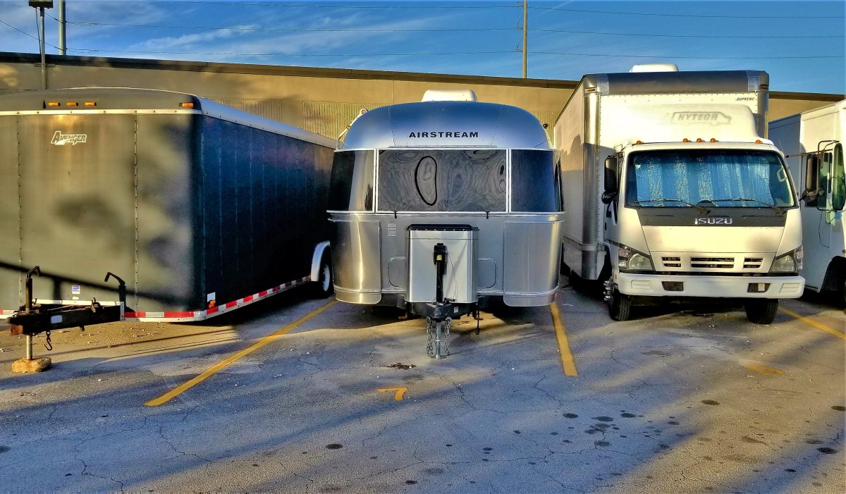
I’m happy to report that the angel who whispered directions in my ear delivered me to the promised land–helping me to navigate the back end of the Airstream between the Isuzu on the right…

right side

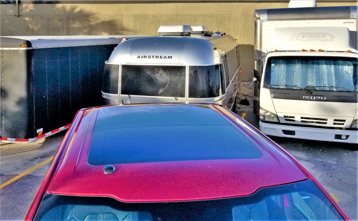
and the Avenger on the left–

left side

despite limited swing clearance from the front of the F-150.

parked

When all the paperwork was finally completed, and the Airstream was left behind, Leah boarded the F-150, and we were on our way to visit a nearby friend in Delray Beach, who would listen to our recounted quest before awakening to an early morning departure the following day.

It was then that Leah shared the news:

“RJ wanted you to know,” she emphasized, “that what you did back there was some of the finest parking he had ever seen.”

That’s the moment I realized that we would never be selling this Airstream!

Moon Over Muddy Mountain

Now that Leah and I are nine months into Streaming thru America, a familiar question often arises from family, friends, and fellow bloggers: “What’s your favorite place, so far?” It still remains the most difficult question to answer. Here’s why:

We’ve covered over 32,000 miles to 104 distinct destinations–with amazing views of beaches, mountains, prairies, canyons, and deserts. We’ve toured cities and suburbs, villages and vicinities, parks and plantations, graveyards and ghost towns.

Thus far, we’ve crossed the country from the Atlantic to the Pacific and back; we’ve traveled as far north as Jasper National Park in Alberta, Canada to the southern edge of Florida within the Everglades; We’ve ascended Trail Ridge Road to the Rocky Mountain tundra at 12,183 feet to the salt flats of Death Valley’s Badwater Road at 282 feet below sea level.

Having slogged through Los Angeles and Miami traffic, we’ve also driven hours through remote regions without a soul in sight. We’ve cursed the crowds at Yellowstone and Zion, and celebrated the isolation of Black Canyon of the Gunnison and Theodore Roosevelt National Parks. We’ve witnessed numerous national monuments, and bore witness to monumental tragedy in Las Vegas.

While we’ve camped at some of the fanciest and most expensive RV parks in the country, we’ve also boondocked at Walmart parking lots, always meeting new people from around the world, yet reminiscing with old neighbors we discovered at a scenic overlook in North Dakota.

Despite having written over 80,000 words and shared over 2,500 photographs of our adventures this year, I feel compelled to answer that one nagging question, but forgive me if I pause for a moment longer to filter all the information collected to date…

The one location that stands out over all the others is Valley of Fire State Park–16-miles outside of Overton, Nevada–as much for the solace and cleansing it brought us after the Las Vegas massacre, as for it’s raw and natural beauty.

And from this experience, I’ve reluctantly selected one photograph that captured my imagination and exemplified my feelings–two days after the world grappled with senseless inhumanity.

sheep and moon (4)

May 2018 bring us closer together as we work to build bridges between communities, and discover a path to peace and tolerance.


Home Invasion!

As if straight out of a horror film, our Airstream has been overrun by ghost ants. This wasn’t the first time we’ve seen bugs in the trailer, because bugs are an undeniable consequence of living outdoors, and a way of life. However, while occasional spiders, love bugs, moths, gnats, no see-ums, and mosquitoes have all managed to infiltrate our home at one time or another, it’s not until recently, that so many unwelcomed six-legged insects have made themselves comfortable without an invitation.

Long considered a well-established resident of South Florida and other tropical and subtropical environs, Tapinoma melanocephalum workers are thought to have illegally immigrated from Asia or Africa–where to this day, as an affront to our democracy–they continue to worship their queen, while spreading their vermin and contaminating our food.

Despite their small stature, at 1.3 to 1.5 mm long, I’m certain that had there been a border wall to protect us from this infestation, these pests would never have gone on to infiltrate the foundation of our trailer, and rob us of our American dream.

And had the FBI taken notice and properly profiled these larvae from the beginning, none of this would have ever happened. To be sure:

They have 12-segmented antennae with the segments gradually thickening towards the tip. Antennal scapes surpass the occipital border. Head and thorax are a deep dark brown with gaster and legs opaque or milky white (Creighton 1950). The thorax is spineless.

The gaster (swollen part of abdomen) has a slit-like anal opening which is hairless. (Smith and Whitman 1992). The abdominal pedicel (stalk-like structure immediately anterior to the gaster) consists of one segment which is usually hidden from view dorsally by the gaster (Creighton 1950). Stingers are absent.

The small size, combined with the pale color, make ghost ant workers hard to see (Smith and Whitman 1992).

At the very least, these ants have been extremely annoying, invading every part of the Airstream in a matter of days. We discovered them in the kitchen, in the bathroom, in the closet, in the bedroom, and ON MY PILLOW! EWW! Leah has been reflexively swatting phantom bugs from her arms and legs at the the very thought of our new colonists.

Quickly, ants were now to blame for every miscellaneous skin bump, itch, or irritation on her body.

While camping at John Dickinson State Park in Jupiter, it was hard to ignore the many ant hills throughout the sites. I backed the Airstream into stall #43, and soon located several small cones of sand with limited ant traffic. Being careful to not disturb them, I thought they might return the favor, but the ants had a different agenda.

“Oh my God!” shrieked Leah. “They’re everywhere! They have to be stopped!”

Leah laid into the ants like they were ISIS terrorists. Her flip-flop was a particularly effective weapon in her campaign to eradicate the enemy. WHACK! WHACK! WHACK!

“Gotcha!” she bellowed.

She came down hard on the ants, but there was no quit in their little legs as they they rebounded in their crazy dance, scurrying around in all directions at once, before darting into their hiding places–provoking her ire and igniting her wrath.

“We’ve got to do something!” she vowed.

A trip to the garden section of Home Depot offered several interesting choices that promised instant relief, but we opted for Raid. Somehow, the notion of killing ants with a lightning bolt stirred our sado-masochistic sensibilities.

retail bait

After returning to the Airstream, Leah tore into the packaging with a vengeance. Out popped eight plastic bait traps, looking like a mini Buster Keaton pork pie hats.

Declaring all-out war on ants, we strategically scattered them around the Airstream, often debating the locations of the most effective kill zones. For the most part, I acquiesced to Leah’s judgement, so long as I secured rights to wage war in the bathroom, which I considered my domain.

I closely observed the ants racing inside the aluminum channel along the wall, and knew exactly what I had to do. I wedged one of the little white poison pucks behind the soap dish, and waited for the feeding frenzy. After a minute or so, a curious ant came to inspect the trap, as if the Sirens were luring it to its certain death…

ant on a trap

…and swallowed it whole.

ant takes the bait

“Yes!” I exclaimed. “One by one, you will eat the poison and die!”

I launched into my end-zone victory dance with a firm belief that we were now winning the war on ghost ants like never before. And that there will be so much winning, that we will tire of winning so much.

**Feature Image: Ghost ant worker, lateral view. Drawing by Division of Plant Industry**

Eureka!

A stopover in Eureka Springs, AR along the way to Branson, MO produced some Eureka! moments and other assorted revelations.

For one, there are seventeen registered churches in Eureka Springs, ministering to two thousand healing hearts and souls around town, plus a Tibetan Buddhist temple and an integrated monastery of celibate brothers and sisters.

Religious overtones are also pervasive throughout town. Our Airstream was parked along Passion Play Rd., above the hallowed hollow where The Great Passion Play’s dramatic reenactment of the last week of Jesus Christ is the #1 tourist attraction in the area, and The Christ of the Ozarks rises nearby, hovering above the dense woods of Magnetic Mountain.

Jesus of the Ozarks

Christ sign

Big Jesus side view

Also looking down from town, the Crescent Hotel–recently added to the National Register of Historic Places–delivers luxurious living and salon services, in what’s billed as America’s Most Haunted Hotel.

Historic Crescent Hotel

Crescent Hotel

A fourth-floor lookout…

P1100279

provides familiar views in the distance,

Jesus over sunset

and an overlook of St. Elizabeth Catholic Church of Hungary–listed in Ripley’s Believe It or Not as the only church in America with entry through the bell tower.

St. Elizabeth Church1 (2)

Stunning religious “art-chitecture” can also be found at the Thorncrown Chapel, a jewel of glass and wood tucked into the hillside atop a ledge of flagstone.

Thorncrown Chapel1 (2)

Inside Eureka Springs’ Victorian historical district, the Byzantine-styled First Baptist Church stands at the corner of three intersecting streets with entrances at each of its four levels, giving it four distinct addresses and cause for another Ripley’s entry.

First Baptist Church

The charm of downtown carries through its narrow winding streets, acute corners, and graded roads of 30% or greater, routinely decorated with accents of fine art…

down the street

Steps to Spring St.

…and frivolity.

Humpty Dumpty gnome

horn orchestra (2)

Eureka Springs came by its name naturally, manifesting no less than sixty-two springs that gushed from the mountainside with so-called healing properties. Its establishment as a resort community during the 1870’s prompted visitors from near and far to “take the waters” by drinking up and soaking in its therapeutic juices.

civil war healing

90% cure rate

Today, over a dozen springs have been restored to former glory.

Magnetic Spring plaque

Magnetic Spring

And while the water is no longer potable, the park habitats have given the springs a new lease on life,

Harding Spring

Basin Spring

and have renewed the town’s reputation as a popular healing destination,

Eureka Healing (2)

with an emphasis on preserved charm.

County Courthouse

top floor (2)

ball and house

facade

facades.png

Palace Hotel gazebo

Perhaps the biggest paradox of Eureka Springs would have to be the town’s united commitment to all things ghosts and Halloween, given its adherence and roots in Christiandom, while billing itself as “the place” for the best Halloween party in America…

Grand Central Hotel

Chile Lily

…breathing spiritual relevance into Euripides’ quote: Money is the wise man’s religion.

Palo Duro Canyon Tailwinds

Wouldn’t you know it?! Texas has a Grand Canyon of its own in the middle of its panhandle called Palo Duro. And the best way to see it is from the saddle of a horse while riding at the bottom of the canyon floor.

We’d been wanting to go horseback riding for the past few months, but something always interfered with our plans, or time wouldn’t allow. But Leah was determined.

“If you can ride in a balloon, then I get to ride a horse,” she declared.

And true to her word, reservations made on Thursday got us an early ride time with Jennifer at Old West Stables inside the state park.

stables

stables1 (2)

We mounted Buster and Lloyd,

our ride

and rode along an unmapped equestrian trail that took us along the foothills of the canyon walls…

on the trail2

and through the hills and ravines of a basin carved by the Prairie Dog Town Fork of the Red River over one million years ago.

We passed colorful rock formations resulting from a geologic compression of four distinct periods layered over the course of 250 million years.

canyon wall.jpg

While I enjoyed the scenery, and the quiet of the canyon,

canyon peak

canyon strata

I had the disadvantage of riding behind Leah’s horse, Lloyd.

Leah and Lloyd

Lloyd was a farter who always positioned himself behind the lead horse.

on the trail3

And no matter how many times I tried to hold Buster back…

on the trail4

…we would always find our way back behind Lloyd’s swishing tail,

Buster follows too closely

where Buster was always greeted with a slow and steady current of foul wind, followed by an evacuation.

The hour passed as easily as Lloyd’s breakfast, and we found ourselves back at the stable, in time for Lloyd’s lunch.

back at the ranch

Once finished, we took a ride back to the lodge at the top of the canyon for a better perspective of the second largest canyon system in America,

canyon vista1

overview detail

before returning to the basin’s scenic road to explore the Big Cave,

BC trail

an opening in the red rock that’s not as big as it’s unusual.

cave entrance

cave mouth1

Big Cave inside out

cave opening (2)

The Texas panhandle is as flat as a cowpie, and wide as the open sky.

Airstream sunrise1

Thankfully, Palo Duro Canyon provides some variety to a linear landscape, and adds some color to a pale prairie palette.


Milestones

What started out as an intimate blog intended for sharing our cross-country adventures with family and friends has taken on higher meaning and greater dimension. After seven months of 100 posts, 10,000 views, 4000 visitors from over 150 countries, and a new family of nearly 1000 followers, this blog has eclipsed all that I could have imagined.

It has changed how I look through a lens and how I craft a story. It has transformed my posts from informative to entertaining. The discipline has made me a more fluent writer and sharper photographer, for which I am thankful.

Your collective thoughts and comments are a driving force to improve my content, and I am grateful for the feedback and acknowledgement.

I’d like to think that this evolution and subsequent statistics are because of my new and loyal audience, and I thank you dearly.

Additionally, my apologies to Leah, who must now contend with my newest obsession.

Sleepless in Las Vegas

Seldom am I so amazed that I am speechless or at a loss for words…

After visiting twenty-nine U.S. National Parks, four Canadian National Parks, a dozen National Monuments, numerous State and Provincial Parks, and driving thousands of miles of scenic byways over the past twenty-nine weeks,

captured on:

Leah and I have yet to discover a place that is so captivating that we didn’t want to leave…until now.

Rainbow Trail panorama (2)
Leah and me

Valley of Fire State Park allowed us the chance to finally exhale, after America held its collective breath trying to make sense of yet another senseless killing spree, when a maniacal sniper opened fire on a crowd of 20,000 innocents a ¼-mile away.

We were 4½ miles out of harm’s way, staying at an RV resort off I-15 at the time, and wondered about the incessant sirens screaming past our open windows after 10 pm that fateful evening..

“I can’t believe how much crime they have here,” Leah exclaimed.

“Wouldn’t want to live here,” I offered.

Switching on the TV, all stations were locked on breaking news of an active shooter at the strip, but details were sketchy with the story developing by the minute. We quickly realized that we were listening to the soundtrack of a massacre: SWAT teams, police, EMT, and ambulances were sprinting past our Airstream–in and out of the danger zone.

Originally, we booked a couple of days in Vegas to decompress, and intended on exploring the strip in search of available show tickets once the Airstream was unhitched. But the prospects of casino crawling quickly faded after an afternoon of relaxation by the pool. Then again, we figured there would always be tomorrow.

Yet by morning, as the tragedy at Mandalay Bay unfolded, the thought of unthinkable loss left us gasping for air.

Leah summed it up: “It doesn’t feel right having fun when we’re surrounded by so much pain and suffering.”

We needed a getaway. We took off for Red Rock Canyon to escape the inhumanity, and clear our heads.

Callico 1

Keystone Notch Trail

Red Rock Canyon panorama

It was a small dose of nature for the day, and helped to heal our heavy hearts.

The following day, we moved our Airstream fifty miles east, to the Valley of Fire, where we found the perfect antidote to murder and madness. We found a place where we could breathe,

rainbow road (4)

and the only sound at night was silence.

The park has an abundance of features and formations.

Beehive2
Beehives
Arch Rock1
Arch Rock
Elephant Rock
Elephant Rock
Silica Rock
Silica Dome
Atlatl Rock
Atlatl Rock
Mouse's Tank
Mouse’s Tank

But the hiking trails off White Domes Road offer the biggest reward.

Rainbow Vista  gave us an opportunity to scramble over rocks with more colors than a box of Crayolas.

Roadside formations1 (2)

Roadside formations2 (2)

Roadside formations3 (2)

Roadside formations4 (2)

Roadside formations5 (2)

Roadside formations6

A loop through the deep red sands of White Domes transported us to the 23rd century set of Star Trek: Generations.

monolith (2)

White Dome Trail2

slot canyon2

Slot canyon4

canyon opening

keyhole (2)

A stroll through Fire Canyon during late afternoon gave us the impression that each rock radiated from within.

Fire Canyon (2)

rock foot

Magic light

Fire Canyon Arch

sundown

But I was unprepared for the exhilaration I felt after reaching the Fire Wave.

FW8

FW7

FW3

FW1

FW9

FW2

FW6

FW5 (2)

I’ve adopted Valley of Fire as my Muse. Even now, when I close my eyes, I believe I’m  living in Candyland–a magical world where the cliffs look like candy, and all the residents of the world are tolerant of each other. 

This post represents a milestone of sorts, as its #100 in my series of posts for Streaming Thru America–a blog intended to showcase and celebrate the diversity of beauty throughout the country. I dedicate #100 to all the victims, and their families, and I salute the first responders, the good Samaritans, and the medical personnel, who continue to fight for the living.

How Low Can We Go, Part 1

Death Valley is known as a land of extremes. From atop Telescope Peak (the highest point in the park at 11,043′) it’s possible to see the highest point in America (Mt. Whitney at 14,505′) and the lowest point in North America (Badwater Basin at -282′)–all from the same spot. The Panamint towers on the west hold onto snow for three months of the year during winter, while the valley below is the driest place in North America, with annual rainfall under 2 inches. Temperatures have ranged from 134° F to 15° F at Furnace Creek’s weather station.

At 3.4 million acres, Death Valley is the largest National Park outside Alaska. The park is 140 miles long and demands reliable transportation due to its vast and unforgiving character. Nearly 1000 miles of pavement and dirt roads provide access to numerable sights, but the conditions are so punishing, that picking and choosing what to see and do requires reasonability.

With only two days to see the park, Leah and I split our tour around the park’s extremes: on day one, we’d drive the busy low elevation roads–where the weather reigns hotter than anywhere else in the western hemisphere–to explore highlights to the east; and on day two, we’d travel the remote off-road trails to the west, in search of cooler mountain air.

To make it easier on ourselves, we parked the Airstream on an expansive open gravel lot at Stovepipe Wells, where a dozen other trailers and coaches joined us as we listened to early morning howls from a pack of coyotes hunting the birds that frequent the septic pump at the far end of the campground.

A restless night gave way to a convenient start the following day, with a quick trip (almost unheard of in this National Park) around the bend to Mesquite Flat Sand Dunes.

dunes1

Wandering out to the highest ridge at 100 ft. can be arduous, as the shifting sand will swallow every step.

dunes

However, better traction is available in the dune valleys, where the hard crust anchors the creosote and mesquite shrubs.

Mesquite Sand Dunes

We continued past Furnace Creek…

CA-190.1 (2)

until we reached the Golden Canyon. With the sun arcing across the eastern sky, we wove our way through the passage,

canyon opening

always hugging the canyon walls where we could for a chance at shady salvation.

canyon shade

While the sun was relentless, it was the scenery that left us breathless.

Einstein rock

Golden Canyon spur

Cathedral Red Rock

Back in the truck with the air conditioning cranked to recovery mode, we took CA-190 past the Artists Drive detour, and turned onto a last ditch road that resembled the landscape. At the end of the quarter-mile was a large clearing smack in the middle of an alien landscape called Devils Golf Course*, an immense arena of jagged rock salt deposits turned into land mines that makes for hazardous hiking.

golfcourse panorama.jpg

Devils Golfcourse1.jpg

While no one can ever prepare for surviving in extreme heat for extended periods of time (by now it was now 103° F), we were ready to take our chances in Badwater Basin–the hottest and deepest place in America.

Walking onto salt flats that cover 200 sq miles sounds as overwhelming as it should,

Salt Flats (2).jpg

…yet the impression of watching people walk out so far they almost disappear, helps put the enormity of Badwater Basin into perspective.

Badwater

Leah and I u-turned from this point, and back-tracked to Artist Drive–nine miles of looping and dipping black-top that weaves through narrow rock channels until it opens onto a gargantuan portion of Neapolitan ice cream known as Artists Palette.

bowl of gelato

Five million years of eruptions altered by heat and shaped by wind and water has produced a spectrum of colors across the slopes. On closer inspection, the colors are surreal.

Artist's Palette

Palette detail

While the truck had enough fuel to carry us another two-hundred miles, Leah and I were running out of gas. As we’d ride from one spot to another, we’d repeat the same refrain throughout the day: “Oh, wow! Did you see that? That was amazing! How is that even possible?” We were living on fumes of inspiration.

We closed the day with a visit to Zabriskie Point,

Badlands

a magical setting that showcases the harsh beauty that makes Death Valley so unforgettable, and a place that can awaken the hibernating soul within us. Some go so far as to breach the safety of the overlook, and climb closer to the edge to symbolically feel closer to their personal truth.

One such group of chanting and meditating hippies was seated on plush mats near the cliff edge, their diaphanous silks of many colors flowing in the hot breeze. They were seemingly oblivious to the large number of amateur shutterbugs who were standing on the observation platform and complaining about their compromised view of the Badlands.

Since I believe that we all share the same view equally, I took a narrow path down to where they were sitting to set up my camera shot. I nodded politely as I crossed their viewing angle, and bid them hello.

“I’ll bet their grumbling up there about how we’re spoiling the view for them,” declared the Elder.

“Yeah, there’s a lot of that going on,” I indicated, “but the light won’t be like this forever, so ‘I’m not gonna waste my shot.’

Zabriskie Point

Elder stated, “Y’know, if they were that bummed out, they’d come down here the same as you”

Setting up my shot, with my back to Elder, I commented, “That’s true, but many aren’t as bold as you, and just as many can’t physically make the climb down here. Figure it out!… While you’re praying for world peace, you’re also ignoring the needs of people right behind you.”

“I guess that’s true,” noted the Eldress.

I took the shot…

Zabriskie panorama

and hiked back to where Leah was standing.

“Y’know that group of hippies below us? I think they’re leaving,” I announced.

“That’s gonna make a bunch of people happy,” predicted Leah.

When I saw them rolling up their mats, I figured that like me, they probably had enough heat for one day, or they finally came to their senses before the heat robbed them of their last strand of reasonability.

* Not a Trump® property yet, but the family is working on it!

Close Calls

We arrived at Marine Corps Air Station Miramar for the Air Show, but couldn’t park any closer than one mile from the tarmac–where all the action was happening. I suppose if we wanted to upgrade from free to VIP status, we could have enjoyed preferred parking privileges closer to the airfield, but it was a beautiful day for a walk through a military base in sunny San Diego.

I was directed by Marine plebes to a general admission parking lot bordered by McDonalds and Chipotle. Leah and I opted to carry our own lawn chairs and snacks in lieu of paying for grandstand seating or any of the other enhanced options intended to pamper guests, including: a shaded lounge, gourmet food stations, a hosted bar, a commemorative coin, and less-frequented Porta Potties. But bringing our own chairs to the air show gave us more flexibility to move around the base. Besides, it was a beautiful day to schlep a heavy metal chair in a bag through a military base in sunny San Diego.

I think we were midway to the airfield, and steps away from the first security checkpoint when I saw something that deserved a second look through my camera. I peered through the viewfinder to discover the low-battery warning flashing in the frame before the screen went dark. Of course, it was my intention to exchange this battery with the battery charging inside the truck before we headed out, but I guess I was distracted by the notion of walking through a military base in sunny San Diego on such a beautiful day.

Leah found cover under a tree, while I dropped my chair and water bottle and hiked back to the truck to recover the freshly charged battery. Twenty minutes later, I rejoined her and we crossed the road where we were greeted by three security officers in camouflage fatigues.

The ranking officer addressed Leah first. “I’m sorry to tell you ma’am, but you can’t enter a secure facility with that fanny pack around your waist. For everyone’s security and protection, all bags…unless they’re clear…are prohibited.”

It was no use arguing with three people in uniforms on their own base, but Leah objected, “But I’m only carrying my water, my wallet and some snacks.”

The officer continued, “Your choices are to surrender it here and I can let you pass now, or return it to the safety of your vehicle if you still want to own it.”

And that’s when I remembered the graphic that caught my eye before my camera failed.

be-clear-header.jpg

“Do you have any idea how far it is to our car?” I interjected.

“I’m aware, sir, and there’s nothing I can do about that. Clear bags are the rule for everyone’s safety and protection,” he reiterated.

“I’ve just about had it with this air show!” Leah exclaimed, and stormed away. But she never got very far. She was delayed at the crosswalk by the marine directing traffic.

“I have an idea,” she said sotto voce, as I caught up with her.

We crossed back to the other side of the road, and turned into a nearby barracks parking lot away from view.

Leah removed her black waistpack and emptied the contents. Out came the water thermos, the wallet, and a baggie of pretzels. She loosened the chair bag drawstring, and stuffed the waistpack deep into the chair bag with the fragile pretzels sitting on top.

Cinching the drawstring, “I’ll be damned if I’m gonna give them my fucking bag!” she exhorted. With her water in hand and wallet in pocket, we crossed the road for the third time.

I proposed, “They’re never gonna believe that we ditched the pack in the truck and made it back this fast. So if they ask, we tell them that we handed it off to a friend to hold for us. Okay?”

Leah indifferently, “Whatever.”

When we approached the security team, Leah mimed that the pack was gone. “Are you gonna let us in now?” she mocked.

“I’m sorry for the inconvenience, ma’am. I hope you enjoy the show,” he stated sincerely.

“Isn’t there some kind of shuttle for senior citizens?” Leah intoned, playing the sympathy card.

“If you cross to the other side of the road, there’s a golf cart that will carry you and your things to the gate for 3 bucks a person,” he answered.

“How far’s the gate from here?” I asked.

“Straight up this road, ’bout half a mile,” security responded.

Leah outraged, “Are you kidding? Six bucks for half a mile? No way!”

“You’re right,” I reminded myself. “It’s such a beautiful day for a walk, lugging a heavy metal chair through a marine base in sunny San Diego.”

After arriving at the airfield gate, we were stopped by a second security detail dressed in pressed khakis and carrying guns.

“I apologize, but those chairs can’t enter this facility because they’re in bags,” an MP declared.

“You’ve got to be shitting me!” Leah unloaded. Emphatically, “Then why didn’t those boys down the road stop us at the time. They saw us carrying these bags over our shoulders,” she declared.

I covered my face to hide my grin. This was turning into a huge clusterfuck.

I took a breath. “What if we took the chairs out of the bags, and carried the chairs to the airstrip?” I suggested diplomatically. “Then it’s just a chair and a bag, instead of a chair in a bag.

They looked at each other and shrugged. “No problem, sir.” Followed by, “Please enjoy the show.”

We stripped the bags off our chairs, with Leah being especially careful to reposition and secure the waistpack into the folded seat.

“Thank you for that, now may I please see your IDs?” stated the second officer.

Leah dug her wallet out of her pocket, thumbed through her cards to locate her licence, and handed it to the third officer, who scanned it with his portable reader.

I was incredulous. “You’re not gonna believe this…” I started out.

Leah was glaring at me.

Continuing, “…but my wallet’s in my truck parked a mile down the road, and I’ve already had to go back once to get a fresh battery for my camera. So, there’s no way of showing my ID unless you guys wanna drive me back,” I lamented, “even though it’s a beautiful day for a walk through a military base in sunny San Diego.”

He looked the two of us over. I desperately communicated telepathically that he was putting my fate in Leah’s hands, and that he needed to show some sympathy and mercy.

Surprisingly, the marine announced, “Don’t worry about it. Just enjoy the show. Beyond this point, no one’s gonna hassle you for ID.”

Taken aback and winking, “Thank you. You may have just saved my life.”

After clearing checkpoint two, we advanced to the third and final security detail whose job it was to scan our bodies. We emptied our pockets onto the tarmac, and stood with arms and legs locked in a frozen jumping jack, while a soldier ran his wand up and down and around.

“All clear,” he announced.

We collected our belongings, and shuffled along with full arms.

“That was a close call,” I whispered.

“You’re telling me,” Leah laughed. “They would have found my camping knife in my pack.”

We weaved our way around small pockets of people–on the left side of a thinly populated grandstand,

Grandstands

and settled three deep from the front fenceline to see what everyone else had come out to see–the elite precision flying squad known as the U.S. Navy’s Blue Angels.

While clearance can be a serious issue when pulling a trailer–and I’ve had my share of close calls with our 28 ft. Airstream: like backing into a sleeve of an RV site with little to no front-end swinging-room; or negotiating a tight parking lot; or backing out into a busy road after inadvertently turning into a dead end–it still can’t compare to formation-flying in a $60 million aircraft with 22,000 lbs of thrust with only six inches separating the wingtips of two F/A-18 Hornets.

duet

After fueling, the fighters lined up in take-off order,

Blue Angel lineup

and took to the sky in a burst of thunder.

delta formation

A variety of formations quickly consumed an hour of time…

2 up 2 down

2 up 2 down1

breaking off

and approximately 4250 lbs of fuel (or roughly 600 gallons) per plane.

4 abreast

banked formation

The Department of Navy estimates an average running cost of $11,000 per hour to fly each plane,

landing

with a yearly operating budget for the Blue Angels at $35,475,000.

side by side

While I’m far from militaristic, it’s impossible to ignore the skill set and nerves of steel of the U.S. Navy’s most accomplished pilots, and their ability to control a mighty military machine for the purpose of entertainment versus destruction.

And that’s what I call a beautiful day in sunny San Diego!

4 across


Knock, Knock

We are anchored at RV site #1 at Pine Mountain Lake Campground in Groveland, CA, the closest town (albeit 24 miles away) from Yosemite’s western gate. The sites at PML are terraced on a steep hilltop better suited for mountain goats, although there is 50 amp power and a water bib, should goats ever feel the need for air conditioning and a shower.

The pop-up caravan at site #2 has just packed up and pulled out, leaving us completely alone and feeling somewhat relieved. After being cramped for so long at so many “RV resorts”, it’s nice to enjoy the breathing room that comes from having space on both sides of our home, when more often than not, RV parks keep us closer to neighbors than a Grey Poupon commercial.

Yet, despite the constant flux of RV park populations, and the proximity of rigs from stall to stall, there is an unwritten code of ethics that’s very reassuring–where neighbors seem to respect the property of others that typically extends beyond the footprint of one’s camper. Unattended grills, bikes and lawn chairs are a large part of open-door living at campgrounds, and are seldom disturbed by others.

However, when left alone, the isolation can be disquieting and peculiar, leaving us to wonder what it’s like to be on our own.

After breaking camp by mid-morning, the enervating 100 miles of stop-and-go driving from June Lake, over the Tioga Pass, through a crowded Yosemite NP to our final destination at Pine Mountain Lake took up most of our day. Ordinarily, after setting up, a secluded mountain setting would invite us to open our windows for a crisp cross-breeze of fresh air, but Groveland had served up a helping of haze with a side a smoke, giving us little choice but to button-up the Airstream to protect us from the effects of fires in the forest.

Leah was first to bed, while I spent some time editing photos for the blog. I don’t know exactly what time I fell asleep in front of the computer, but I was startled awake at 11:30 pm by a knock on the door, followed by a weak plea for help.

Shaking off the groggy feeling, I turned up the lights and fumbled to unlock the door. Had I been more coherent, I probably would have ignored the distress call, and filed it under “too weird for worry”. But instead, I reacted otherwise.

“Are you in some kind of trouble?” I asked, cracking the door a few inches.

A disoriented rail of a woman with pulled-back hair and dressed in black spandex workout gear was standing by my door.

“I’m lost, and I need a ride home. Can you please drive me to my house?” she pleaded.

“What are you doing here?” I asked, growing increasingly suspicious of her request, and feeling angry that I may have put Leah and myself in jeopardy by answering the door.

“My husband and I had a disagreement and he dropped me here, and I have no way of getting home. I live on the mountain, but I don’t know where I am, so could you please drive me home?” she reiterated.

She didn’t appear upset–just confused, but so was I.

When Leah and I began preparations for our year-long adventure, a common question among friends and family was, “Are you taking a gun with you?”

My response was always the same: “Are you fucking crazy?” But now I’m not so sure.

“I’m not from around here, so I don’t know how to get you home,” I asserted. But what I was really thinking was: “You’ve got to be kidding if you think I’m leaving Leah behind, while you ambush me outside the Airstream or on the way to your home.”

“Then will you let me use your phone so I can call someone?” she suggested.

I anticipated the question. “I’ll be right back,” I announced, closing the door. I reached for the phone I recently replaced two weeks ago, switched on the exterior light, and re-opened the door to find her drinking from a large water bottle. I wondered what else she was hiding on the other side of my door.

“Since we don’t know each other,” I volunteered, “how ’bout I dial the police for you, and you can ask them directly for help?…”

She hesitated as I entered 9-1-1, “…Cause it sounds to me like this warrants a call to the police.”

“Sheriff’s office, what’s your emergency?” answered dispatch.

Switching the phone to speaker, I offered, “I’m calling from Pine Mountain Lake Campground in Groveland, CA. A woman has knocked on my camper door who claims that she’s lost and unable to find her way home. Are you able to help her?”

“Is she still there?” asked the dispatcher.

“She is, and she’s asked me to drive her to her house somewhere nearby,” I confessed.

The dispatcher took over. “Are you alright ma’am? Are you hurt in any way?”

The stranger responded, “I’m okay. I just don’t know where I am is all, and it’s dark, and I don’t know how I’m gonna get home.”

The dispatcher continued, “Can you tell me your name and where you live?”

“My name is Amber and I live at 20247 Longview St.,” claimed the knocker.

“Were you born in 1964?” asked the dispatcher.

“Yeah,” responded Amber.

“Well, this office is not a taxi service, Amber, but if you like, I can offer you the numbers of a few local cab companies who can get you home,” suggested the dispatcher. “Is that a good option for you?”

Amber, dazed, “Sure.”

To Amber, “Be right back.” I let the door slam behind me, and I scrambled for a pen. The dispatcher dictated phone numbers for three taxi services and signed off.

Getting back to Amber, “I’ve got three choices here. Which number would you like me to call?”

“I don’t have the money for a taxi. Can you just tell me the direction to the main road?” asked Amber.

“Ferretti Road is at the bottom of the hill. You can’t miss it,” I declared, and double-locked the door.

From the “bedroom” Leah called out, “What the hell was that all about?”

“I don’t even know where to start, but I hope she’s gone,” I asserted.

“Maybe we should bring in the bear spray from the truck as a precaution,” Leah recommended.

“Only if you get it,” I replied.

“Fuhgeddaboutit! I’m not stepping out there,” exclaimed Leah.

At Leah’s suggestion, I called Pine Mountain Lake Association security, who completed a sweep of the property, but came up empty. Their promise of an increased patrol through the night was reassuring, but the peculiar notion of ever enjoying peace and quiet as a solitary guest in a campground now seems highly overrated.

Redwoods and Blue Seas

California stopped us right in our tracks. We had just crossed the Oregon state-line, only to be unexpectedly diverted to a border patrol checkpoint.

“What could we have possibly smuggled into California from Oregon that would need further inspection? Maybe they’re looking for the coyote who’s been running Canadians into the States?” I posed.

“More likely, there’s a bounty or some kind of quota for captured Mexicans,” Leah contributed.

Ahead of us, the RV from Nevada was being questioned. He pulled away, and then it was our turn.

Waiving us forward, “Wow,” the California agent exclaimed. “You guys are all the way from New Jersey?”

I’m almost certain his eyes lit up behind his dark glasses. “Do you know anything about gypsy moths?” he asked.

“We are, and I do,” I responded to both questions.

“Well then, since you won’t be needing this brochure about gypsy moths, would you do me the favor of pulling up to those cones over there,” he indicated, “and I’ll have an officer come by to check things out in a jiffy. We won’t keep you very long.”

“Are we really getting checked for moths?” I asked rhetorically, as I crept to the cones.

“I don’t know,” Leah admitted, “but I can see two guys in my mirror, and they’re coming up to the Airstream, and one of them is carrying something big, but I can’t make it out.”

“I suppose it makes sense, considering the importance of protecting America’s timber land,” I stated. “In fact, what this country needs is a net. The United States government should cast a tremendous net over America’s airspace to protect us from immigrant leaf-eaters that only mean to do us harm. These are very bad bugs–the worst you’ll ever find anywhere–and these bugs have to be stopped before they threaten the security of this great country. Believe me. Thank you very much.” I campaigned.

“And this net…are you gonna get the bugs to pay for it?” Leah mused.

The inspector set the car dolly on the ground and crab-walked around the Airstream undercarriage while on his back, poking around with his fingers and a flashlight. He started on the left side of the Airstream, and I followed him as he scooted under the tail to the other side for more of the same.

After completing the circle, he stood and declared, “All clean. These campers are completely sealed. Those guys do a good job.”

“And made in America!” I chimed in.

He stamped my official Certificate of Inspection, and bid us safe travels.

certificate-of-inspection.jpg

Certified predator-free, we were now permitted to resume our journey throughout California, with Redwood National Park as our first stop.

Redwood National Park is a splinter of a park that hugs the rocky northern coast, and reaches across the Yurok Reservation and reciprocating California State Park affiliates.

Because Redwood is not a traditional National Park, it can easily get under your skin. Navigating through the blurred lines of park boundaries always had me wondering if we were “in” the park or not, as we rode Redwood Highway through forests and meadows to beaches and towns.

Unlike other parks, there is no entrance fee, but then again, there’s also no practical way of collecting a fee when the road is open to all traffic.

We set up camp on the bank of the Klamath River,

Klamath River sunset (2).jpg

and explored in earnest the following day when we followed the river to the estuary,

Klamath channel (2)

where a family of barking sea lions,


and humans…

ocean play

…frolicked in the sea spray and sea foam.

sea foam

We continued our hike along the Coastal Trail, with views north…

Bird Rock

…and south of High Bluff overlook.

coastline overlook

“I miss the ocean,” I confessed to Leah. “There’s something serene about staring into the surf.”

Although three months had passed since visiting the Jersey shore, I was immediately transported back to a familiar scene of waves rhythmically crashing against the rocks.

crashing waves

“Let’s go find some redwoods,” Leah advocated, pulling me out of my trance.

We branched out to a deeper part of the jigsawn park, and settled on a grove of giants dedicated to the beatification efforts of Lady Bird Johnson by Richard Nixon.

Lady Bird plaque

With ancient redwoods as old as 2500 years and reaching upwards of 380 feet, the notion of something bigger than oneself becomes more than a literal interpretation.

sunglow

skyscraper

treetops

redwood grove

How fortunate we felt to be bathed in streaming shafts of light–dancing between feathered limbs, and flickering in the balmy breeze.

shafts of light

There’s much to learn from trees that have survived the dinosaur. Redwoods are a family of trees that share root ancestry to keep them anchored. They propagate by seed or by sprout, and are known to sacrifice themselves for the benefit of the younger and stronger sibling.

twins

The redwood’s bark may grow to two feet in thickness to protect itself from fire damage. However, repeated fires can eventually penetrate through the bark, leaving the tree to rot out from the core,

burned out redwood

and yet…it may still survive.

burned out but alive

Even in death, there is a twisted beauty to be found in its decomposition.

rotting stump

At the dedication ceremony to honor Lady Bird Johnson, President Nixon intoned,

…to stand here in this grove of redwoods, to realize what a few moments of solitude in this magnificent place can mean, what it can mean to a man who is President, what it can mean to any man or any woman who needs time to get away from whatever may be the burdens of all of our tasks, and then that renewal that comes from it…

As I strolled through the grove surrounded by God’s fingers, oh, how I prayed that Donald Trump could take Nixon’s advice, and listen to the trees’ whispers for just “a few moments”.

Corners

A small corner of the sky captured most of America’s attention and imagination on August 21, 2017. It was the celestial event of the millennia that brought a momentary pause to many people’s lives as they looked up and marveled at the source of our very existence.

Leah and I had our own corner of the parking lot at Benton County Fairgrounds in Corvallis, OR.

Leah lounging

A party atmosphere surrounded us. Some were expecting a spiritual awakening, and some were interested in the science of the occasion, but for most of us it was a social connection. We sat around with family, friends and strangers, looking goofy in our mylar glasses…

3 loungers1

…as we shared a brief moment together as sun worshippers.

We all held our collective breath at the precise moment the moon completely eclipsed the sun. And then there were cheers.

totality

For one brief moment, we were all related. For that one instant during totality, we had turned the corner, and became the human race.

And just like that…

partial eclipse (3)

…it was gone in a flash, and a tear passed the corner of my eye.

Sadly, it’s going to be a long time before our next solar eclipse.

H2O-2-GO

The Icefields Parkway represents the spine of Banff and Jasper National Parks. It runs a crooked line astride the Continental Divide for 140 miles between Lake Louise and the town of Jasper–rising and falling, twisting and turning–as it follows rugged mountain vertebrae, verdant river veins, alpine organs of opalescent waters, and at the heart of it all, the highest concentration of ancient glaciers in the Rocky Mountains.

Athabasca River (2)

While it can take 3.5 hours to complete the journey without stopping, most travelers will take their time, stopping along the way to inhale the majestic beauty. Unfortunately, we were in no position to stop and gawk. We were holding our breath, hoping to arrive in time for a prepaid tour of Athabasca Glacier.

It drove me crazy, passing up scene after scene, my shutter finger convulsing around the steering wheel as we pressed on toward our destination. And even if we had all the time in the world, nearly all the turn-offs were on the opposite side of the road, making it a logistical nightmare for the Airstream behind us.

“All I can say,” lamenting to Leah, “it’s a good thing we’re coming back the same way, so we can stop as much as we want to take it all in.”

Leah had no objections.

Having started from Banff Village, we were among the last of 56 ticket-holders to be scanned for the 2:30 tour, only to stand by for another half hour…

waiting in line

…until a bus could drive us to the Ice Explorer depot…

ice explorer depot

…where we waited another 15 minutes for an available Brewster behemoth of our own. I was excited to take the ride onto the glacier in this buggy, although the boarding sign caused Leah some anxiety.

warning

We learned from Ryan, our twenty-something driver, that the tires are 5 feet in diameter, rated at 15 pounds pressure (half that of an auto tire) so they don’t harm the ice, and cost $3000 a piece.

tires

Once we got rolling, we paused at the crest until Ryan got radio clearance to continue…

Athabasca Glacier crossroads.

…down a 33% grade that pressed us against the front of our seats,

on the road of ice

yet delivered exhilarating views of the glacial ridge,

glacier

and an ice tour in progress to the tongue of the glacier.

ice tour

Before disembarking, Ryan delivered strict instructions: “I want to be clear about this. You walk onto the glacier at your own peril. You have 20 minutes on the ice, that’s it! This bus leaves at exactly 3:45 pm, no exceptions! Any questions?… Good! And don’t forget to fill up your water bottles. This is the purest water you’ll ever drink.

With that said, we climbed down the ladder stairs, and joined approximately 300 sightseers already on the ice.

explorers on the ice

Almost immediately, there was a surge to the rope line 200 ft. ahead, where a Battle Royale ensued for unobstructed “selfies” of the glacial mouth. We stood in awe of the competitive scramble,

portrait

which was a huge distraction from the awe of the terrain.

glacial ridge

Of course, with the clock running down, we turned our attention to the glacial spring running through the middle of the pedestrian corral.

flower and ice

ice water

so Leah could fill her bottle with 200 thousand year-old vintage water.

glacial water

After returning to the depot with all passengers accounted for, we boarded another bus that continued to Brewster’s Glacier Skywalk,–a glass-plated arch nearly two inches thick, suspended 800 feet above the valley floor–

glacier skywalk

glacier bridge

steel supports

giving us commanding views of Athabasca Mountain,

Athabasca Mountain

the corresponding run-off,

waterfalls

stormy river

…and a local grazer, precariously gripping the mountainside.


Even now, I’m uncertain how the mountain goat turned itself around.

Not that l’m complaining, but one year ago, Leah and I had an opportunity to visit the Juneau Icefields by helicopter…

flying over Herbert Glacier

and step onto Herbert Glacier where nobody was waiting.

landing on Herbert Glacier

Herbert detail

The remoteness gave us a completely different perspective and appreciation of nature that Brewster was unable to deliver.

But at the very least, we left with a bottle of chilled glacial water.

Cheers.

Ahhh!


A Park Where Nothing Happens

Riding Mountain threw us off our game from the very start. We were eager to visit our first Canadian National Park–as the whole country and its visitors from outside are celebrating Canada 150 with free admission to Parks Canada–but we really didn’t know what to expect. Our experience with National Parks in America allows us to anticipate the awe inspired by iconic landmarks. For instance: Arches has Delicate Arch; Bryce has the Amphitheater; Yellowstone has Prismatic Lake and Old Faithful; and Grand Canyon has, well, a grand canyon. How would Canada’s parks hold up by comparison?

I knew we were in trouble the moment we arrived at Sportsman Park in Onanole, Manitoba, a self-proclaimed RV Park located minutes from the Riding Mountain entrance. We were looking for a spacious and grassy pull-through to match the website picture that lured me into making a reservation. What we found was a cramped and worn neighborhood of crusty campers settled onto dirt patches where a blade of grass struggles to be green. It reminded me of an internment camp for refugee trailers.

A misfit on a motorcross cycle guided us to a site that challenged the laws of physics. To start with, making a wide turn onto the designated lane required a full-timer to deconstruct a portable basketball hoop struggling to stand on the corner lot. Once clear, we continued to Row B/Site 14, where our ambassador coached me around a parked car and a sprawling tree, through a raised curb, and beyond a floating wood deck that prevented the Airstream door steps from fully extending. Somehow, I managed to inch between two trailers with extended slide-outs.

Ian, my new next-door-neighbor, commented, “Didn’t think you were gonna make it, eh?”

“How do people usually manage to get into this spot?” I wondered.

“Nobody ever does,” Ian responded. “This spot’s gone vacant for more than a year.”

“You been here that long?” I doubted.

“Goin’ on five years, now that I have a son an’ all,” Ian beamed.

Ian was gracious and full of information. “Be careful at night, eh” he warned. “There’s a bear been pokin’ around here last couple nights, ever since the guy across the way spilled some grease. So it’s a good idea to always have a flashlight handy, eh.”

Note to self, “Stay inside the Airstream after dark.”

The following day, we headed for the Interpretive Center for a customary face-to-face with a ranger. He explained that Riding Mountain is at the confluence of three distinct ecosystems: prairie, boreal forest and hardwood forest. It’s divided into Front Country and Back Country with over 400 km of trails, and home to elk, moose, coyotes, wolves, lynx, beaver, bison, and the largest black bear population in North America.

“You know what to do if you encounter a bear, don’t-cha?” asked Ranger Scott.

“What do you recommend?” Leah asked.

Ranger Scott explained, “When you go into the woods, you need to smell like a human. That means you skip deodorant for the day! And make sure your clothes don’t smell like what you had for dinner. Don’t carry unwrapped food with you, and don’t forget to make some noise on the trail while you’re moving. Should you meet a bear, DON’T RUN! Just step back, never looking directly at the bear.

“What about bear spray?” I was curious.

“Never use the stuff,” Scott boasted. “But I always wear an extra shirt when I’m hiking, no matter how hot it is. So if necessary, I spread open the shirt with my arms out like this [demonstrating], and right away that bear is now lookin’ at someone who’s doubled in size. Saved my bacon on a couple occasions using that technique.”

We left Scott with a decent idea of how we’d spend the next couple of days. For starters, we took a perimeter trail around Clear Lake in the village of Wasagaming, with the lake to our left,

Clear Lake

and an array of charming cottages and cabins on our right. In a unique arrangement with Park Canada, home owners lease their property in perpetuity from the government. When title to a home is transferred to another family member, or is sold outright to a buyer, the lease always becomes a part of the deal. But if government regulations are ever broken, the tenant can be evicted and dispossessed.

Curious about the value of  Wasagaming lakefront property, we did a little digging…

and found a newly remodeled 3 bedroom/2 bath 1700 sq. ft. bungalow listed for $800,000 CAD, but we weren’t ready to move to Canada just yet.

We continued our day with an off-road ride to the top of the Manitoba Escarpment, with hazy views from the overlook,

Manitoba Escarpment view

and followed the road to the park’s east boundary, where the distinctive East Gate Entrance Building (the only surviving gate structure at Riding Mountain) gave us a glimpse of traditional 1930’s “parchitecture”, and reminded us of a time when motorcars were first gaining in popularity.

East Gate West Sun

That evening we took a sunset walk on the Onanole Trail beside the RV Park. The trail began at the gnomes’ house…

Troll House

continued through a pine forest, and opened onto an expansive field of prairie grass, taking us around to a wooded opening on the other side of the field.

Prairie grass and Leah

We would have continued along had it not been for the volume of bear scat littering the trail.

That night, Ian’s campfire went well beyond the midnight quiet-time curfew, causing Leah to lose sleep while I stayed up to write.

“Isn’t there something you can do?” she complained.

But before I could offer my ugly American alibi, one of the party people yelled out, “BEAR!”

The commotion was over in a flash and so was the party. “Well, that was effective,” I mused.

The next day, we elected to hike around Moon Lake,

Moon Lake

taking a 9 km loop trail through high, hearty shrubs and poison ivy. It was not what we expected; the lake had disappeared from view. The trail was heavily overgrown and still wet from a flash thunderstorm the night before, making the moose prints more imposing.

moose track

With Leah in front, calling off bears and moose, and me in the rear, swatting away voracious mosquitoes, we wondered if this hike would ever end. Midway through the hike we encountered another couple taking the loop from the other direction.

“See any bears or moose?” Leah questioned.

“Lots of tracks, but no animals,” he answered. “Yet I sense we’re being watched.” she volunteered. “Anyway,” she continued, “there’s a lovely clearing ahead. Enjoy.” And they were gone.

The flat trail turned steep as we climbed into a grove of firs, and we caught our first glimpse of the lake we were circling.

Moon Lake Overlook

Soon we were bordering the banks, stepping over freshly broken plant stalks that only a moose could manage. Suddenly, Leah stepped into an uncertain spot that swallowed her boot whole, and caused her to lose balance, plunging the other foot into even deeper mud. I might have taken her picture, if I wasn’t so busy pulling her free, and I was certain that she’d forgive me later.

We emerged tired, muddy and grateful to have put this hike behind us, but still curious about the bison enclosure at Lake Audy one hour away. We’d made it our mission to see at least one wild animal in this park–even if it meant watching a small herd of bison roaming through the prairie…again.

But there were no bison grazing, or roaming, or rolling in the dust, anywhere. The viewing deck that overlooks the grasslands held no surprises, and was devoid of beasts of any kind.

Yet, it was hard to ignore the swooping passes of several starlings that darted in and out of the gallery. A closer look around the rafters, gave us the gratification we were searching for.

Heads and tail

Feed me (2)

Yum

Half a million visitors arrive each year to Riding Mountain to enjoy the crystalline water of Clear Lake, or stroll through the charming town of Wasagaming, or angle for trout and walleye in the streams and lakes, or hike and bike through biodiverse ecosystems, but mostly people come to witness the wide assortment of wildlife.

Unfortunately, Leah and I found no animals present, although we’re certain they were around us–which is why we believe that Riding Mountain National Park is for the birds.

Facing the Future of Awareness

The van in front finally pulled away, making it my turn to methodically approach the gatehouse window with the Airstream in tow. But nobody was home. Leah noticed an outstretched arm extended from a raised window a dozen feet forward, and it was waving me closer. I inched parallel to the higher window, and awkwardly offered our documents.

“You realize you’re in the wrong line?” he criticized.

“There was no sign,” I responded sheepishly.

“Take off your sunglasses,” he ordered. “Where are you going and what’s your purpose?”

“We’re on our way to Winnipeg to celebrate Bastille Day,” I announced.

“Bastille Day, huh! So you’re up for a couple of days?” he barked.

“Actually longer, about four weeks,” I offered. “We’re here to tour your beautiful country… drive across to Calgary and visit Banff and Jasper before returning to the States.”

“You carrying any drugs, alcohol, guns, ammunition?”

“No.”

“You ever visit Canada before?”

“Yes.”

“When last?”

“We were in Alaska last summer and crossed over to Yukon.”

“How much money you carrying?”

“About a thousand dollars.”

“Enjoy your stay,” he stated dryly, handing back our passports.

We were immediately reminded of driving in a foreign country when the road signs posted maximum speed limits in km, and the bi-lingual billboards promoted it products in French.

“How do you know how fast you’re going,” Leah posed?

“I have a button on the steering wheel,” I bragged, pushing the button. “And it automatically makes the adjustment on the display. Voila!”

“So cool,” Leah deadpanned.

The Bastille Day ritual was being held au petit jardin de sculptures beside the old City Hall-turned tourism center/art gallery in the Franco-friendly Winnipeg ward of St. Boniface. Children with painted faces played with balloons, while parents drank wine and ate smelly cheese poured over stale-crusted bread. A trio played behind a chanteuse doing an Edith Piaf impression, and the mood was festive. We left early, thinking the celebration was anti-climactic.

The ride home took us across the Red River, where we previewed a hulking structure that is Canada’s newest national museum, and Winnipeg’s newest tourist attraction and controversy.

bdlg rear

The Canadian Museum for Human Rights, completed in 2014, sits atop the Forks–long considered sacred ancestral soil by the Aboriginals, and part of Treaty One Territory. Instantly, the site selection sparked passionate criticism from Aboriginal elders, who argued for more time after 400,000-plus artifacts were discovered during initial ground-breaking and subsequent archaeological excavation.

Protests continued throughout construction by advocacy groups who perceived that inadequate exhibition space would never address the scope of one group’s suffering, while other advocates claimed that another group whose misery was elevated to a higher status was granted more square footage than deserved.

And to complete the spectrum, there were activists who were bitter that some atrocities were being ignored, and consequently delegitimized. One group felt disrespected after learning that their group’s exhibition space was adjacent to the rest rooms.

Then there were critics who had ideologically opposed the architecture design, likening it to a modern Tower of Babel. But veteran planner Antoine Predock defended the symbolism behind his vision:

The Canadian Museum for Human Rights is rooted in humanity, making visible in the architecture the fundamental commonality of humankind-a symbolic apparition of ice, clouds and stone set in a field of sweet grass. Carved into the earth and dissolving into the sky on the Winnipeg horizon, the abstract ephemeral wings of a white dove embrace a mythic stone mountain of 450 million year old Tyndall limestone in the creation of a unifying and timeless landmark for all nations and cultures of the world.

museum entrance

A dozen galleries stretch between alabaster ramps acting as spears of light connecting the void of black-washed canyon walls.

ramps and roads

The alabaster bridges provide needed tranquility time to survive the intensity of the previous gallery and avoid potential human-condition overload.

The galleries are immense shadow boxes for interpretive technology…

1st nation basket

meaningful art installations…

ceramic tapestry Bistro sculpture

red dresses

animated graphics…

queer wedding cake

Human rights time line

and traditional prose…

Quotes from Weisel and Frank

Primo Levi

All human beings are...

In hindsight, I would start the “trek of travesty” at the top, and wind my way down the “ramps of reflection”–much like the Guggenheim Museum in NYC…

ramp

until reaching the Garden of Contemplation on level 3, where hexagonal rocks of basalt buttress placid pools of water,

Garden

catching surreal reflections,

Garden of Contemplation

under a towering canopy of limestone, steel, and glass.

roof structure

elevator towers

On the other hand, by cruising the museum “upside down”, visitors may lose sight of the painful journey endured by the many who struggled for acceptance and equality. And skipping the Tower of Hope is a missed opportunity to circle the observation deck, with its expansive view of Riel Esplanade and more.

Riel Esplanade

Winnipeg is a city in transition seeking to compete on a national stage, while coming to terms with disaffected Aboriginal people who represent 10% of the local population. Fortunately, the Canadian Museum for Human Rights can be called upon to remind us of the importance of awareness, critical thinking, and reconciliation.

Turning Points for Humanity


Cavfefe

What better way to escape the summer heatwave than to explore a cave. But Leah and I were literally at a subterranean crossroad of epic proportions. South Dakota’s Black Hills boasts two of the most highly respected holes in the ground anywhere in the world, and we only had time to explore one of them. Would it be Jewel Cave National Monument or Wind Cave National Park? Which cave deserved our business?

The driving distance didn’t matter since only 30 miles separated both locations. But there were other factors to consider when evaluating which cave is the better cave. When it comes to status, Wind Cave wins hands down, since it’s a National Park, and everyone knows that a National Park can’t be Trumped. On the other hand, Jewel Cave is only a National Monument, and monuments can be Zinked at any time.

We had to consider how Jewel Cave’s grand viewing rooms are endowed with a stunning collection of traditional stalactites and stalagmites, while Wind Cave holds 95% of the world’s rare boxwork formations.

As for whether size matters, Jewel Cave ranks third worldwide–four places ahead of Wind Cave at number seven in the world. However, Wind Cave has the most complicated and concentrated matrix of any cave system in the world, with new veins still being tapped.

And then there’s temperature. Jewel’s thermostat is set at 47°F, whereas Wind turns up the dial to 53°F, registering “six degrees of separation”.

And both caves offer an extremely popular assortment of tours that always sell out early on a first come first serve basis.  Such a dilemma!

What’s an amateur spelunker to do?

Social media was consulted in deciding the matter, but there was no clear winner. While Jewel seemed to win the popular vote, Wind was preferred by the experts for its unique characteristics and wall structure. Yet, neither side could come together to form a coalition of consensus or compromise. And whose to say if there was voter tampering, or how many were fake views?

If travel maven and cave cognoscenti couldn’t figure it out, then how were Leah and I going to manage.  We gave consideration to caves previously visited since starting out on our trip: Mammoth Cave in KY, Kickapoo Cave in TX, and Carlsbad Cavern in NM. But in the end, we settled it by tossing a buffalo head nickel. We figured, either way, we couldn’t go wrong, as long as we got there early!

And the winner was tails…

tails

no passing zone

We were on our way to Wind Cave, and time was of the essence, but try explaining that to the road hogs (bison) blocking the road.

As expected, the Visitor Center parking lot was filled to capacity. I dropped Leah at the entrance crosswalk where she made a beeline for the ticket counter–beating out a Medicare couple, an escort pushing a wheelchair, and a busload of boy scouts.

And it paid off. We scooped up the 11:20 am Natural Entrance Tour (shown in red),

map

which officially started at a marked clearing, featuring a hole in the ground the size of a ranger hat. Ranger Lisa demonstrated the barometric possibilities with a yellow ribbon: if pressure rose inside the cave, the ribbon would blow outward from the hole; but if cave pressure was low, the ribbon would be sucked inward–making this a cave that “breathes”.

Ranger Lisa punched her secret code into the keypad, and the steel door buzzed open, like a scene from “Get Smart”. We followed a dimly lit channel of steep stairs that snaked through a claustrophobic passage of popcorn-coated walls,

popcorn.jpg

until we reached the Post Office. I can only surmise that its name comes from the butterfly of boxes stretched across the ceiling…

Room 2 ceiling

with the names of past generations of visitors posted inside the boxes

artifact

ceiling graffiti

wall

We followed Ranger Lisa down another set of meandering stairs along a poured concrete walkway that took Civilian Conservation Corpsmen eight years to complete, hauling inner tubes filled with sixty pounds of wet cement around their necks. We reassembled as a group at Devil’s Lookout to examine a ceiling dominated by intricate boxwork and delicate needle-like growths of calcite called frostwork.

looking up

That’s when Lisa cut power to the lights and the cave went dark. We were instructed in advance to turn off all phones and shutter all cameras. Children with glow shoes were warned to stand still or risk an extra minute of darkness away from mom or dad.

The darkness brought giggles and Halloween howls from some of the kids, but for many it was a minute to imagine what it was like to be led by Alvin McDonald on a candlelight tour during the 1890’s, when it only cost a $1.00 to crawl through the dirt.

The tour concluded in the assembly room with a brief discussion about the geologic timeline–when the cave was born between 40 to 50 million years ago as determined by sedimentary layers of rock pressurized in the cave walls.

collapse

Finally, the fastest elevator in all of South Dakota whisked us to the surface, and the tour was history.

elevator

Dear Trip Adviser, I believe that going to Wind Cave National Park was a good call, ’cause there was lots of really neat stuff on the walls and ceiling, and especially ’cause I got to pinch Leah’s ass when the lights went out.

Ride ’em, Cowboy!

We drove into the storm until it surrounded us. Lightning was brewing in the distance and then it was beside us. “Do you think they’re gonna cancel if it’s raining?” inquired Leah.

I really didn’t have an answer. “I’m certain that rain or shine is pretty much the rule here. This event is sold out, and there are no rain-checks for this sort of thing,” I hoped.

As we were approaching Belle Fourche (known as the geographical center of America), the rain abated. We dodged a bullet, but the evening was early. We navigated our way through town by following the crowd.

Townsfolk were homesteading on their claim of sidewalk with folding chairs and coolers in an effort to capture the best view, hours before the fireworks. Leah and I were on our way to our first rodeo in the “official” middle of nowhere.

We picked up tickets at will call, and continued through a cowboy arcade of beer, buckles and bows, mixed with the sweet smell of manure. We were shown to our seats by an usher in his sixties. Wiping them dry, the usher cautioned, “I hope I only need to do this once.”

“How much did it rain here?” Leah wanted to know.

“Not so bad. Couldn’t tell ya if it’s gonna start up again, and I used to do weather forecasting for a living,” the usher confessed. “But you know what they say about South Dakota weather?… ‘If you don’t like the weather, wait fifteen minutes and it will change.'” I looked up from my seat. We were sitting in Row C, and the overhang eave was positioned perfectly over our heads.

“Could that explain why you’re an usher today?” I jested.

The usher turned back without hesitation. “That’s what my wife asks!”

The evening opened with a salute to America. Retired Sgt. 1st Class Dana Bowman, Special Forces maneuvered through a dark and gloomy sky, dangling from his Coca-Cola-sponsored parachute.

skydive salute

Bowman streamed into the arena amid cheers, proving to naysayers that the first double-amputee ever to reenlist in the military has the audacity to demonstrate that disability is only a state of mind.

skydive complete

The 98th Annual Black Hills Roundup attracted cowpokes from near and far,

chew and spit

each one competing for a share of $170,000 in prize money with a daring-do skill set that defies sanity. It’s risky business, but the guys on the rodeo circuit take a beating for eight seconds of work–often times coming up lame and short on funds.

thrown

Yet, if they don’t remount, there’ll be no payday. So riding injured is a way of life. The roundup was filled with traditional rodeo events:

flying cowboy
Bareback Riding
The cowboys ride one handed and cannot touch themselves or the horse with their free hand. The cowboys spur the horse from shoulder to rigging, trying to make a qualified ride of 8 seconds. Cowboys are judged on their control and spurring technique, and the horses are judged on their power, speed, and agility. A good score in the bareback riding is in the mid 80’s.
steer wrestler
Steer Wrestling
Steer wrestling is a timed event, and cowboys compete against each other and the clock. Bulldoggers start out in the box just like the tie-down and team ropers. The barrier is placed across the box and the steer is loaded into the roping chute. As soon as the cowboy nods his head the steer is released and he charges after it on his horse. The steer wrestler catches up to the steer as quickly as possible and then leans over, jumps off of his horse and grabs the steer by its head. A winning time is usually between 3 to 4 seconds, but these big boys keep getting faster and faster. Breaking the barrier in the steer wrestling results in a 10 second penalty which effectively puts you out of the money. The bulldogger then plants his feet and tosses the steer onto its side, thereby stopping the clock.
saddle bronc
Saddle Bronc Riding
As with bareback riding, the mark out rule is in effect. The cowboy spurs from the front of the horse, back to the skirt of the saddle in an arcing motion. The cowboy must constantly lift on the hack rein to keep his seat in the saddle. Scoring is the same as in all the roughstock events with 1-25 points given to the cowboy and 1-25 points for the animal by each of the two judges. Cowboys are judged on control, spur motion, and timing. Saddle broncs are judged on their bucking ability. A good score in the saddle bronc riding is in the high 80’s.
bull rider before
Bull Riding
As with bareback riding, and saddle bronc, bull riders ride with one hand and cannot touch themselves or their bull with the free hand. Doing so results in a no score. Two judges give 1-25 points for the cowboys performance and 1-25 points for the animals performance. 100 points being the maximum, and is considered a perfect ride. Cowboys can spur for extra points, but just staying on the bull for 8 seconds is the main priority. A good score in the bull riding is in the 90’s. There has been one perfect score of 100 in the PRCA.
bull rider after
 Thrown Bullrider
roping
Team Roping
Team roping is the only team event in rodeo. The two cowboys involved in team roping have unique goals. The first, known as the header, does just what the name implies and ropes the head of the cattle. The other cowboy, known as the heeler, ropes the heels or legs. The header is the first out trying to rope the head as quickly as possible without breaking the barrier. Once the catch is made the header dallies and turns the steer left. This opens up the way for the heeler to work his magic and rope the legs. The clock is stopped when there is no slack in both ropes and the horses face each other. If the barrier is broken a 10 second penalty is added to the time. Also, if the heeler manages to catch only one leg, then a 5 second penalty is added. In addition to these penalties there are only 3 legal catches that the header can make. These are: both horns – one horn and the head – the neck.

Barrelman Dennis Halstead provided slapstick shtick between events, while concessions provided corn dogs, cookies, and coffee.

clown

Not to be outdone, Cowboy Kenny Bartram and his protege performed X-Game stunts on their steel horses after all the real horses had been stabled for the night.

flying cycle

And if that wasn’t enough, the night finished with a flurry of fireworks.

fireworks1fieworks3fireworks2fireworks4

It rained for much of the drive back to the Airstream in Rapid City, making the trip longer than necessary, but a time for reflection. The America I witnessed tonight was spirited and inspiring.

It was cathartic for the cowboys to chew tobacco, drink beer and raise hell, while young families dressed their kids in patriotic onesies, and showed off their newest Western boots. It was an evening dedicated to perpetual promotion–from the ads, the banners, the announcements, the props, to the flag-waving riders.

Banner girl

And it was a chance to see how important rodeo is to the qualifiers, and applaud how they risk their futures to compete and entertain the crowd.

But more than anything, I was grateful that I would wake up tomorrow feeling better than the cowboys.

* Description and Rules provided by PRCA.


Eating Crow

We missed it by one day. The Battle of Little Bighorn lasted for two days, from June 25 to June 26, 1876, but the reenactment only lasted for one day, June 25, 2017. Unfortunately, we arrived in Hardin, MT on June 26. Our neighbors–a retired couple from Illinois living aboard a 2004 Classic Airstream–witnessed the battle scene reenacted with the cooperation and support of Montana’s seven Nation Tribes and a team of 7th Calvary portrayers. Marty and Lil were overwhelmed by the presentation and all the dust. Of course, we would visit the National Monument, but it would seem anti-climatic compared to warplay.

The sky was dark, and rain was in the forecast. It had been two weeks since this area had seen rain, but for us, it’s been dry for five weeks through seven states, so the threat of rain was a welcome way to tame the dust.

The drive to Little Bighorn Battlefield National Monument through Crow Reservation was brief, but insightful. Scores of train cars topped with coal sat idly on the easterly tracks parallel to the the road, while the west side of the road revealed worn trailers and abandoned buildings littered with rusted car chassis. The metaphor was so apropos.

The Crow Nation sits atop one of the largest coal reserves in the country–an estimated 9 billion tons. Yet, according to a report written by PERC  (Property and Environment Research Center),

The tribe’s 13,000 members have little to show for their massive energy reserves. Although half of the tribe’s revenue comes from coal, most of it remains underground. Where development does occur, the process is slow and cumbersome. Unemployment approaches 50 percent on the reservation, and tribal members suffer from high rates of homelessness, crime, and inadequate housing.

Nevertheless, a modern medical center and a requisite casino border the National Monument.

holy rollers

Once inside the Visitor Center’s auditorium, adorned by a 40-foot mural across the entrance,

battle mural

a sobering 20-minute orientation film of the battle was introduced by a 65 year-old retired teacher-turned-ranger who asked a provocative question. “This is a very typical crowd who has come to pay their respects to the fallen on this battlefield–both warrior and soldier alike who had risked everything to preserve their way of life. This was a pivotal moment in our nation’s history, that teaches us so much about our values and ourselves, but when I scan the crowd as I do today, I always ask myself, ‘Where are the young people, and how will we manage to archive this remembrance without them?'”

As we walked through the national cemetery,

cemetary

and along the interpretive trail to Last Stand Hill,

LS Hill

the heavy sky befitted the solemness of the scenery.


sculpture CU

The 5-mile drive between Custer Battlefield and Reno-Benteen Battlefield was a time for reflection about triumph and tragedy, victory and defeat, heroism and humiliation. Yet, lighter moments came from a herd of horses who openly grazed by the road,

horses at restgrazing3 horses

at times defying traffic by staring down cars from the pavement. And when the skies could no longer hold on, it started to rain.

We found shelter at a nearby Crow trading post where Leah and I enjoyed a Crow taco made of frybread. Delicious!

taco

The rain abated by the time we finished our meal. Looking west, we saw blue sunny skies which gave us a green light to further explore our surroundings.

Less than one hour away via Fly Creek Road–a gravel pass connecting I-90 and I-94–we passed rolling ranches of grazing cattle and hay field harvests…

hay field

on our way to Pompeys Pillar National Monument,

Pompey Pillar

a massive sandstone butte on the banks of the Yellowstone River. Regarded as holy ground by the Crow people, the rock also represents the only physical evidence of the Lewis and Clark Expedition. William Clark engraved the wall amidst Indian pictographs on his return trip to St. Louis, and chronicled his 150-foot ascent to the top in his expedition journals.

Clark signature

Clark originally named the rock Pomp’s Tower, after a nickname he had given to Sacajawea’s infant son, whom she carried as she guided the famed expedition to the Pacific. It was later renamed Pompey’s Pillar, and dedicated as a National Monument by Bill Clinton in 2001.

pillar plaque

The hungry and persistent mosquitoes we experienced on the trails were worthy descendants of the “misquitor” that so bothered Clark that he couldn’t see to aim his rifle straight.

Our day of American history ended with another downpour on the drive back to Hardin. But we celebrated the brief moment the windshield was free of bugs, and the chassis was free of dust.

via Daily Prompt: Sunny

Gallery

On Steady Ground, Part 3

Leah and I were breaking up with Yellowstone Park. In the beginning, the park had welcomed us and offered us sanctuary. At times, it made us dizzy with excitement. Despite all the wonderful things the park had brought into our lives (the scenery, the animals, and the natural oddities), there was little doubt that the park was making it hard for us to breathe… most noticably by the basin springs belching sulfurous gas.

From the beginning, it was everything we could ever hope for–the park revealing its majestic views of the mountaintops; the regularity of the geysers; the explosive colors of the basin-bacteria; the rare excitement that only a new relationship can bring. And we were intoxicated by all of it.

It was easy to overlook or forgive some of the park’s flaws during our honeymoon phase: the thinning forests ravaged by fire, the intensity of the water from late winter thaw, and the wildlife fickleness. But none of it matters when you’re blinded by the lushness of the meadows, the clarity of the water, and the immensity of the spectacle.

But somewhere along the line, our relationship with Yellowstone soured. While we knew it was unreasonable to expect monogamy from Yellowstone–knowing that 2.2 million acres should be enough to go around for everyone– we couldn’t help feeling neglected, thanks to all the other visitors who were vying for the same attention.

I feared we were growing apart from Yellowstone. Could it be we were no longer compatible? Were our expectations too high and unreasonable? It’s true there were things we wanted from Yellowstone that the park was unable to deliver. In addition to less traffic and fewer people on the trails, we wanted shorter lines at the entrance gate, and quicker service and lower prices at the restaurants. Was that too much to ask for?

Bottom line, we were no longer getting along. The relationship was too one-sided. Leah and I were putting so much time and energy into the park, and not getting enough back in return. The memory of driving three hours, only to travel thirty miles left us disappointed, and frustrated. The imagined traffic violation from Ranger Painter felt like a “double-cross”.

We felt rejected by the park.

But I was still willing to give the park another chance. I thought that things inside the park could be different if it wasn’t a weekend–when the park wouldn’t be as stressed out. Leah, on the other hand, wasn’t as forgiving. “I’m done!” she announced. “I’m not going back.” She was determined to make a clean break of it.

“But it’s not entirely the park’s fault,” I argued, already suffering from an acute case of separation anxiety. However, in my heart I knew I was covering for a park that had let me down.

Maybe Leah was right. Maybe we should cut our losses, and stop beating ourselves up. We needed to put this abusive relationship behind us.

We agreed that we needed to put some space between us and Yellowstone to give us some perspective. A respite from Yellowstone would help to clear our minds and cleanse our hearts of our frayed feeling towards the park. I was tired of feeling angry at Yellowstone, and I wanted the magic to return.

As with any break-up, it’s always best to confide in a friend to gain clarity. Fortunately, a friend living only 100 miles away from West Yellowstone allowed us to overnight at his two-bedroom condo in Driggs, ID. While it was good catching up with George, it was also gratifying standing under a full-sized shower with constant pressure.

We discussed our soured relationship with Yellowstone over dinner with George, Kate (his daughter), and Kate’s husband Kevin, a full-time fishing guide during fishing seasons. It was an awesome reunion, sitting outside in a restaurant garden setting during the summer solstice.

“Crowded park conditions are to be expected this time of year, considering the park’s popularity,” announced Kevin. “It’s the best water for fishing right now, and it’s where I take my clients. It’s simply the best place to go.”

“I wish we had the luxury to return during a different time of year, but this is the only time we’re passing through,” announced Leah.

“I think that sums it up,” I added. “It’s really now or never. Sometimes you have to give a little to get a little,” I opined, sounding too much like Dr. Phil’s proxy.

The following day, we headed over the Teton Pass into Jackson Hole for bagels. We casually walked through town, bracing ourselves for the long ride through Teton National Park and into Yellowstone.

But we had to stop at Ox Bow for one last glimpse of the austere grandeur of the Tetons.

ox bow 1

By 1:00 pm, we crossed over to Yellowstone’s South Entrance. where an idle gate ranger awaited our arrival. Leah and I exchanged an optimistic glance, unwilling to jinx ourselves by stating the obvious. After a quick bite at Grant Village, we continued around West Thumb, where the road hugs Lake Yellowstone, showcasing its bedazzling blue splendor.

We justified a stop at Mud Volcano to stretch our legs…

mud volcano

buffalo mudders

sour lake

mud volcano bird

…before finishing with a rim trail hike to Lower Falls, and bearing witness to the power of water cascading over a sheer cliff,

Lower falls establishingthen crashing against the brush-stroked walls of Yellowstone’s Grand Canyon.

Yellowstone was the first National Park signed into law by U.S. Grant in 1872…

and you never forget your first love.

On Shaky Ground, Part 2

(picture credit: UUSS)

Leah and I passed through the construction zone with time to spare, thus avoiding the road closure, and reducing our stress level. It was 7:00 pm, we were tired, and I needed a break from driving since 10:00 am. If we could make it through the next 28 miles without incident, we’d be out of the park and on our way to dinner. We continued toward Madison junction at a normal pace, until once again, traffic stalled to a stand-still.

Cars were pulling over left and right, creating a logjam. The Gibbon River to my left and the foothills of Mt. Holmes to my right offered scant shoulder room to negotiate a roadside pull-over, yet I managed to maneuver the truck clear of the solid white line to investigate for myself.  Just then, a Park Ranger pulled his patrol car behind me with lights flashing.
“Finally,” exclaimed Leah, “there’s someone here to control this traffic mess!”
I dashed across the road to discover a family of elk dining on long grass on the other side of the river, while the ranger seemed powerless to control the many onlookers. Instead, he joined all us at the water’s edge to admire the scene.
Elk and fawns
I turned to ask Ranger Painter a question. “Is there any concern to the public about the earthquake swarm that’s been recorded since the weekend?”
Since June 12, the northwestern edge of the park (our location) had experienced over 464 events, with the largest quake registering 4.4 magnitude on June 15.
Scientists reported,
“This is the highest number of earthquakes at Yellowstone within a single week in the past five years, but is fewer than weekly counts during similar earthquakes swarms in 2002, 2004, 2008 and 2010.”
The last major eruption of the Yellowstone supervolcano was a magnitude-7.5 event in 1959 at Hebgen Lake–the same vicinity experiencing the latest seismic activity–resulting in a landslide that killed twenty-eight people.
Painter responded, “Is that your red F-150 parked over there?”
“It is,” I answered, “but it’s not for sale,” I added.
“There’s been a report about unsafe driving–that you’ve been passing on a double yellow. Is that true?” asked Ranger Painter.
Incredulous, I asked, “Are you sure you have the right truck? There must be a hundred or more red trucks in the park.”
“But your’s is the only one from New Jersey,” he asserted. “Another ranger witnessed you unlawfully passing, and put in a general call to pull you over. That means I’m supposed to give you a ticket from him for the offense. So, I’m gonna need to see your license, registration and insurance card, please.”
“Are you kidding me? This is extortion! There’s no way I did what he said. And if it’s true, then why didn’t your buddy pull me over?” I insisted.
“Look, I understand your frustration, and I don’t think this is the best way of doing things either.” Painter shrugged, “Personally, I hate doing someone’s dirty work, but I’m just the messenger. This is gonna take a little time, so you’re welcome to continue taking pictures if you want.”
After twenty minutes, the elk returned to the forest, and the crowds diminished. Painter returned to the truck, with my citation. “First of all,” he started, “I want to thank you for not being a jerk.”
“Not my nature,” I declared.
“Good,” Painter responded, “because I didn’t cite you for careless driving like the other ranger advised, which would have been a $200 offense. Instead, I wrote you up for unsafe passing, which only carries a $60 fine… and a $30 processing fee.
“What? A $30 processing fee on top of the ticket. You guys give new meaning to highway robbery,” I alleged.
“What can I say? Everything’s going up,” Painter posited. “Just sign at the bottom,” he instructed, offering the violation notice. “I’m also giving you this flyer, ’cause if you think this is unfair, then call the number and maybe you’ll get the ticket dismissed if you fight it.
“You bet I will,” I pronounced.
“Drive safely,” Painter forewarned, “and you’re in no danger of being caught in an earthquake.”
We finished the ride home to our Airstream in West Yellowstone without words or further incident after completing the Upper Loop in 10 exhausting hours.
The next day, we planned to follow the Lower Loop around, but we were grounded the moment we passed through the West Entrance. Our intention was to leave for the park on the earlier side of 9:00 am, but arranging future reservations in Canada’s national parks had proved more elusive and time-consuming. Consequently, traffic into the park was such a snarl by 10:30 am that cyclists with loaded side bags were making better time. After three hours, we managed to travel thirty ebb-and-flow miles. We were so far behind the tie-up that we could never figure why things were moving so slowly, although we surmised that it was animal-related.
We ate our lunch at Fountain Paint Pot, and walked the boardwalk through a desolate field of fumaroles, geysers, and hot springs, glad to finally stretch our legs. I chose to photograph the landscape as “abstract in nature”, sometimes compressing depth with a longer focal length…
blue flats
Fountain Paint Pot flats
bacteria trail
bacteria swirl
…or extending time by shooting at high speeds…
mudpots
mud pop
…before moving onto Black Sand Basin to capture and accentuate true color through a polarizing filter.
Norris Geyser Basin
 emerald hot spring
prismatic pool
Leah and I agreed that it made little sense to continue the loop. It was already 4:30 pm. We called it quits before reaching Old Faithful, knowing full well that we would be driving into the eye of traffic turmoil, and realizing that the ride back to West Yellowstone could be unpredictable.
We originally planned to explore the park in five days, by pacing ourselves through the highlights, but allowing for a deeper connection by hiking some of the 1000 miles of available trails. But the Yellowstone crowds squashed our enthusiasm, and wore us out. Leah vowed that we would not return to the park in the foreseeable future, even through two more days were scheduled.
Part 3 reveals how we spent the remainder of our time.