A Walk in the Park after Dark

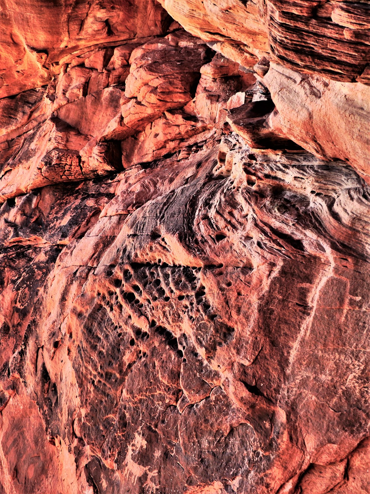
2,500 years before Valley of Fire State Park came into being, the Basketmakers, an ancient American culture migrated across the Nevadan high desert valley to hunt and pray, leaving behind pictographic records of their lives throughout the park’s 42,000 acres.

But Atlatl Rock qualifies as the best preserved and most dynamic petroglyph attracting the greatest number of pedestrians.

Atlatl Rock

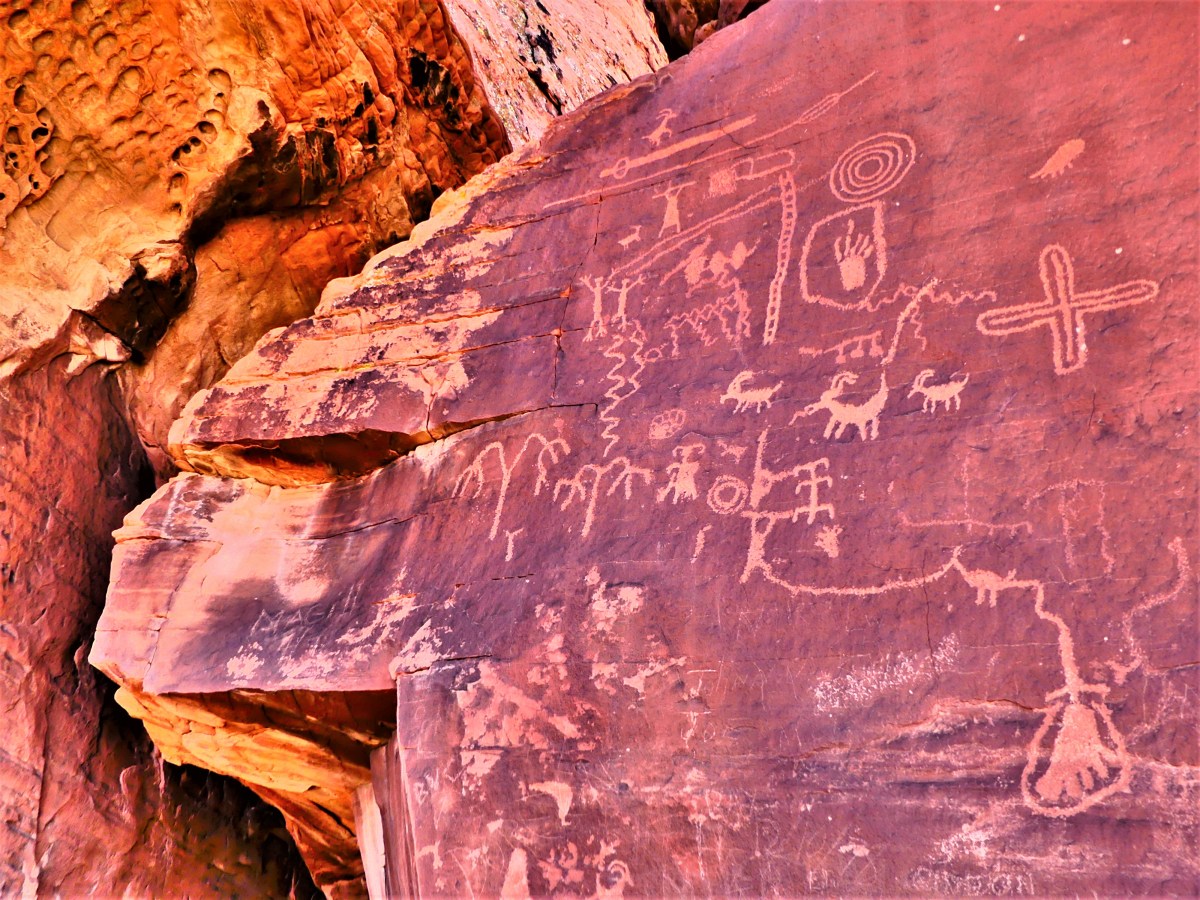
Easily reached by climbing eighty-four steps over fragile sandstone,

84 steps

the symbols etched into the black patina tell an uncertain story, but the symbology clearly features known images–notably an atlatl, which was the “bump stock” of its time. Intended as a spear accessory, the atlatl was a forerunner to the bow and arrow, and used to improve speed and throwing distance when reaching bighorn sheep atop the wildly sculpted cliffs.

animal petroglyph.jpg

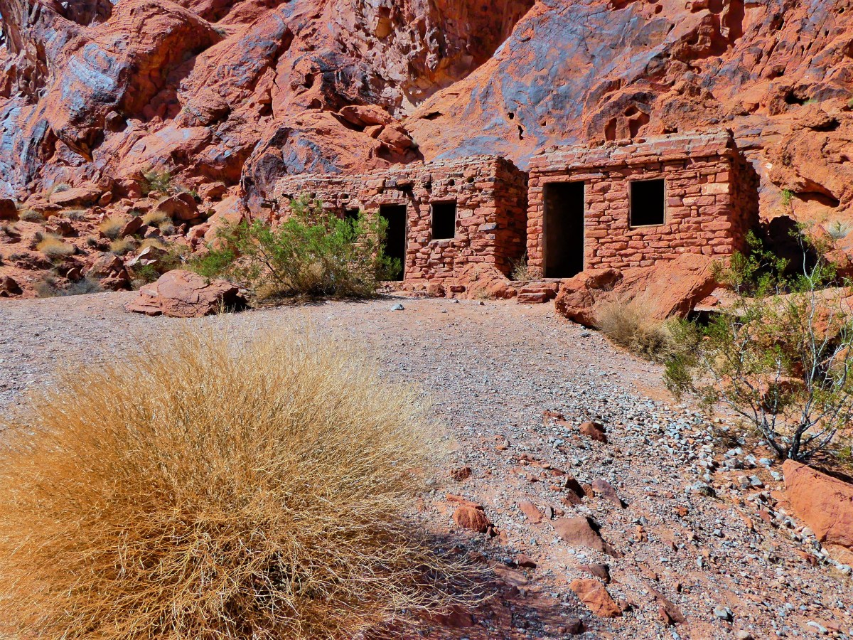
In anticipation of Valley of Fire becoming Nevada’s first state park in 1935, the Civilian Conservation Corps built The Cabins for motorists and pedestrians passing from Salt Lake City to Los Angeles along the Arrowhead Trail.

cabins.jpg

While hiking past Fire Canyon Road in anticipation of a glorious sunset, Leah and I were surprised to encounter a herd of bighorn sheep, perhaps the original inhabitants of the area.

evening graze

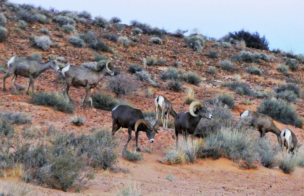
We slowly followed at a safe distance as they’d periodically stop and graze across the hillside while heading for higher ground. Always wary and intently watching,

2 males

the leader of the pack stood vigilant.

leader of the pack

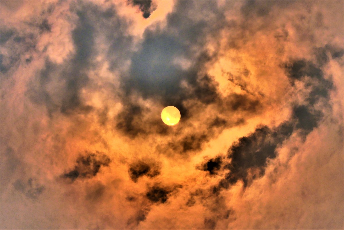
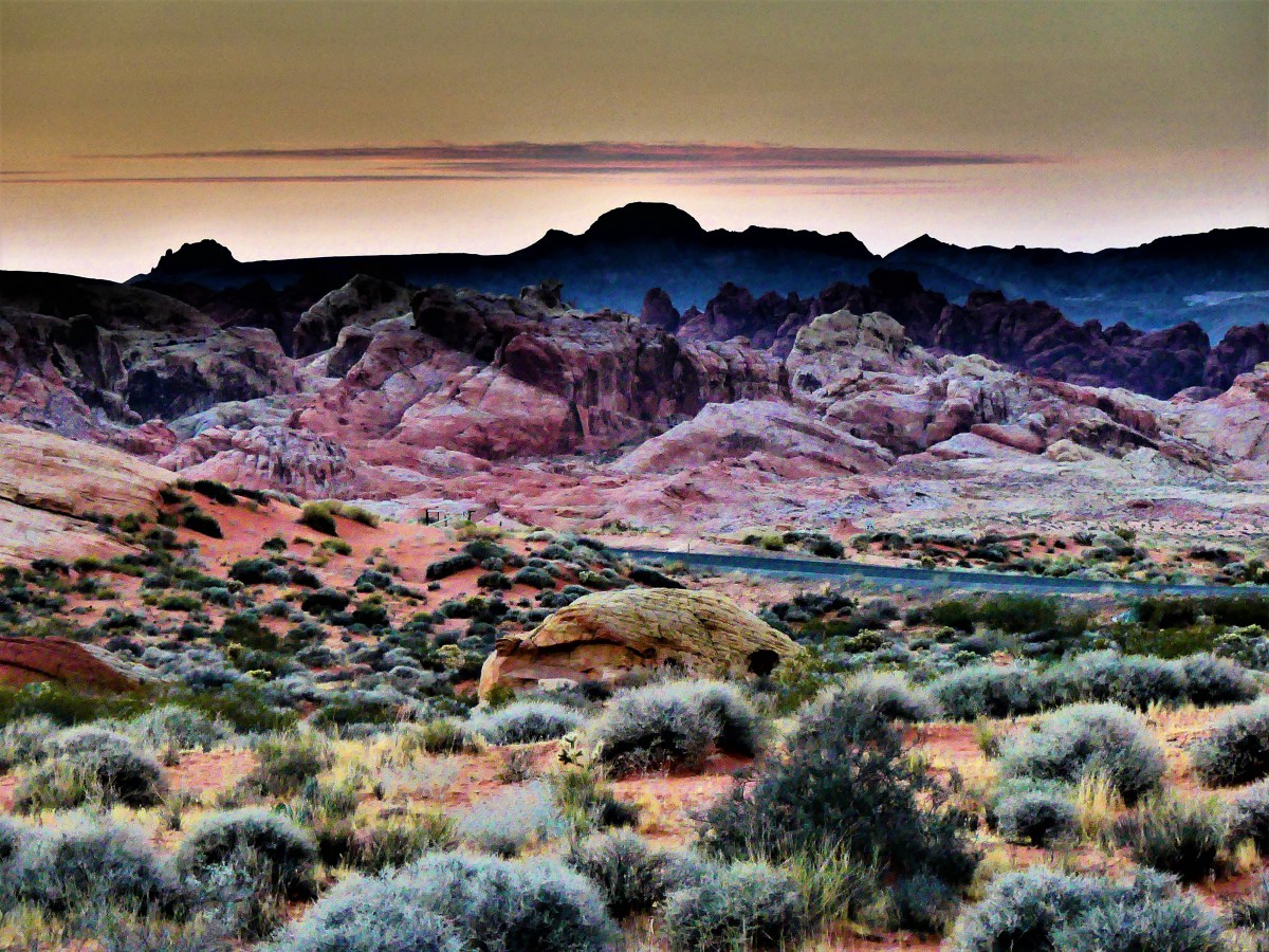
As the sun sank behind the Muddy Mountains,

Sunset over Rainbow trail.jpg

and yielded to a spectacular moonrise over the Valley of Fire,

moonrise over fire canyon (2).jpg

moonrise (2)

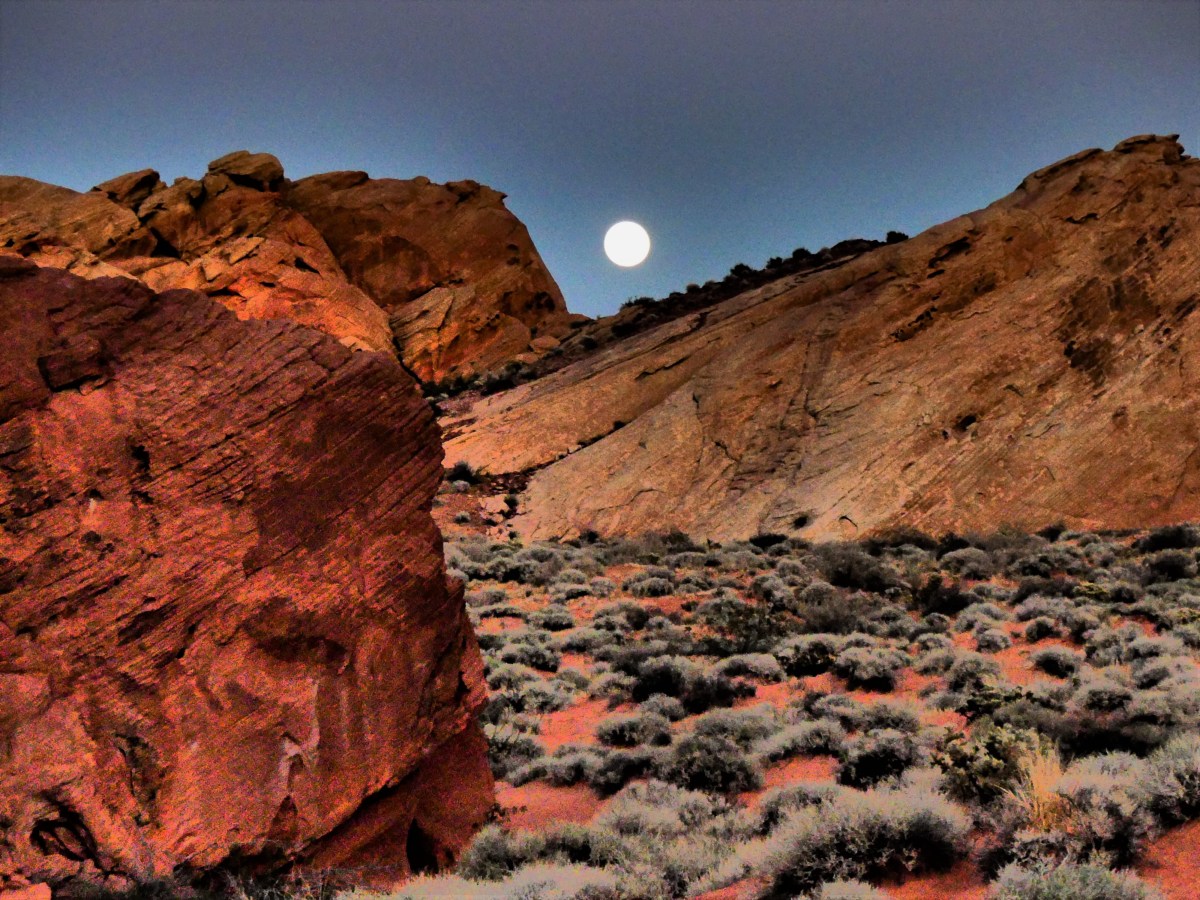
the celestial guardians of the park had found a place where no atlatl and spear could harm them.

sheep and moon (4)


Old Point Loma Lighthouse

Everyday for 36 years, Captain Robert Decatur Israel, the lightkeeper of Old Point Loma Lighthouse would ascend the narrow winding staircase to the glass tower at dusk. With an outstretched arm, he’d light the pilot and adjust the flame that lit the passage for sailors returning to San Diego Harbor. On a clear day, the coastal beacon could be seen from 25 miles out.

But there was fatal flaw in the design. On March 23, 1891, the flame went out forever in favor of another lighthouse built closer to the Pacific Ocean–below the frequent fog and cloud levels–and under the original elevation of 422 ft.

The National Park Service has restored the lighthouse to its original 1855 glory, under the purview of the Cabrillo National Monument,

Old Point Loma Lighthouse1

and protects its five foot French fresnel lens in a protective capsule on the ground floor.

window through the prismatic lens offers a window to the San Diego harbor in the distance, and a second window back in time, where a volunteer in vintage costume brings lighthouse history back to life.

Old Point Loma Lighthouse (2)


window

Window to a Blue Sky

Ranger Pritchett has a lot to smile about. After twenty years as an enforcement officer at Joshua Tree National Park, he’s recently transitioned to a new position inside the visitor center as a naturalist and he couldn’t be happier. When asked about the park’s attractions and variety of activities, he gets very excited about all the prospects that Joshua Tree has to offer, especially during the off-season, when it’s not “crazy busy”.

He highly recommends a visit to Cottonwood Spring—located three miles behind the Cottonwood Spring Visitor Center—where, miraculously, an underground spring feeds a Babylonian-style garden of large growth trees that frame the azure sky.

twin palms

He draws a circle around Barker Dam on our trail map, and encourages us to hike the loop trail that passes Barker Dam, where the water offers a window to the sky;

Barker Dam (2)

and continues through a thick forest of Joshua trees created to frame the rocks and blue sky;

Joshua tree frame (2)

and finishes with an introspection of ancient Indian petroglyphs carved on a sacred rock that vandals thoughtlessly outlined in paint.

20170927_163002

But Pritchett was reticent about suggesting a visit to White Tank campground. When asked why, he allowed, “In my old job, I got called and cornered there all the time. There were just too many people for the area, and once I got in there to control traffic, it was almost impossible to get out.”

But what made it so crowded?” I continued.

That’s when Pritchett criticized the parkitects. “They should never have designated a trailhead through camp site #9.

“A trailhead to what?” I persisted.

“Oh, it’s just the only natural arch in the park,” he mentioned casually. “But I don’t like to tell a lot of people about it. In fact, it’s not even recorded on the park map.”

But he highlighted the area for us on our trail map.

Leah and I were as excited to discover the arch as a Republican repealing ObamaCare. But when we arrived at Site #9, we weren’t alone. A few other couples were also in on the secret, although the trail was not an easy one to follow; the rock path was too easily camouflaged by the desert terrain.

After some unauthorized trailblazing, we located the source of wonder, and scrambled through a crop of coarse granite for a closer look. Looking through a window of the last 80 million years, the endless erosion of wind and water has molded a mini mound of molten magma into a masterpiece.

20170925_143844

However, the biggest window was waiting for us at the top of Keys View. The small crowd began assembling at 6:15 pm. Everyone’s eyes were fixed on the hazy glow of San Gorgonio Mountain to the north,

the sinking sun

and a mirage of a distant Salton Sea to the south– the two connected by the San Andreas Fault…

Coachella Valley and Salton Sea at sunset

all in preparation for a salute to the sunset over Mount San Jacinto, and the promise of a better day tomorrow.

sunset

Channeling the Islands

We are sitting on the water, bobbing on small swells in our yellow kayak while waiting to explore some of the many sea cave options available to us on the southeast edge of Santa Cruz Island, the largest of four northern islands–Santa Rosa, Santa Miguel, and Anacapa being the others–that comprise Channel Islands National Park.

pace setter

With names like Limbo, the Green Room, Neptune’s Trident, Flatliners, and Boatwreck, these grottoes suggest something ominous and sinister to less-accomplished sailors like Leah and me.

The unconventional road to Channel Islands crosses the Santa Barbara Channel from Ventura Harbor via a dedicated ferry chartered by Island Packers.

Island Packers

After boarding the vessel with day trippers and overnight campers, we embarked at 9:00 am for a 1 to 1.5 hour cruise, depending on encounters with sea creatures,

hauling on a buoy
layers of hauled-up sea lions

pair of bottlenose dolphins

dolphin jump

and immense cargo ships entitled to “right of way”.

NYK with dolphin

NYK Argus
layers of containers

Unfortunately, there were no whale sightings, despite being a regular occurrence during summer months, since humpback and endangered blue whales enjoy feeding beneath these krill-rich waters.

After disembarking from Scorpion Anchorage, a short trek past Scorpion Ranch reminded us that this island was once privately owned and operated as a sheep ranch before the National Park Service acquired the eastern parcel during the 1990’s. Machine wrecks layered with rust bordered the road past the ranch house.

dead tractor

dead truck

After layering into our kayaking outfit,

what a couple

we eventually met up with forth-year guide Marc,

Marc the guide

who reviewed safety maneuvers and rowing tips by the launch point.

kayaks

We entered the water at Scorpion Beach,

Scorpion Beach.jpg

and paddled along the southeastern edge of the coastline toward San Pedro Point, where we visited a handful of caves, each one unique and posing a different challenge: whether it was leaning low while paddling to avoid low-hanging rocks from shrinking ceilings; coping in absolute darkness; guiding the kayak through keyhole passages; or timing our exit to avoid being pummeled by surging water.

entering a cave

approaching sea cave

into the cave

sea cave (2)

inside the sea cave

And of course, there were plenty of seascapes along the way.

mooring

rock crops

cove

After two hours in the water, we traded surf for turf, and hiked the canyon loop trail for commanding views of our surroundings. From the Anacapa Passage…

Santa Cruz Island

past a kelp forest…

Kelp forest

…from a wildflower patch…

Anacapa Island

to a chalky cliff at Cavern Point…

Cliff edge

…with a lookout to Prisoners Harbor…

Prisoners Harbor

…and crossing paths with an indigenous creature…the island fox.

fox in repose

Island fox

After meeting a multi-layered sea challenge of kayaking, we boarded the ferry and returned to Ventura–where terra firma meets the ocean, and it’s steady beneath our feet.

Ventura Pier


Gallery

Thank You for Not Smoking

Waiting…patiently.

Waiting…purposefully.

Waiting…painfully.

When will this smoke finally dissipate? I already know the answer…the question was rhetorical. As of today, 74 fires are burning out of control across the western part of America.

fire map of Western states
Current Wildfires

Extreme Smokey

Fires are currently active in nine states throughout the West, according to the National Interagency Fire Center. Here is a breakdown of the acreage burnt so far in active wildfires reported by the National Interagency Fire Center since Aug. 28:

  • Arizona, 1 wildfire, burning 48,443 acres
  • California, 22 wildfires, burning 354,316 acres
  • Colorado, 1 wildfire, burning 1,405 acres
  • Idaho, 19 wildfires, burning 248,141 acres
  • Montana, 26 wildfires, burning 544,583 acres
  • Nevada, 7 wildfires, burning 111,379 acres
  • Oregon, 9 wildfires, burning 146,418 acres
  • Utah, 1 wildfire, burning 5,097 acres
  • Wyoming, 2 wildfires, burning 4,766 acres

For those active fires reported on since Aug. 28 it amounts to 1,464,548 acres actively burnt or burning.

Leah and I have been in the fire zone for over a month–always one-step ahead of the next outbreak–but fire finally found us at Yosemite National Park. Today, the evacuation of Fish Town was lifted, but steps are still being taken to prevent fire from invading Yosemite’s sacred Mariposa Sequoia Grove. Fortunately, Merced and Tuolumne groves remain unaffected.

tunnel tree (2)

roots

fallen tree1

fallen tree

The air is filled with smoke. It’s impossible to ignore…it permeates everything. And nothing stays clean overnight after the ash quietly coats every surface by morning. With the winds blowing, mountains appear…

Tioga Peak (2)

twin peaks

Mt. Dana

Mt. Hoffman

and disappear under a gauze of gray in minutes.

El Capitan

Cathedral Rocks

Fairview Dome1

On a good day, the sun will sometimes break through,

smoky sun

if only to tease the highlights from the shadows.

Tenaya Lake

kairns

tree balanced on rock

Bridalveil Falls2 (2)

But the sky is fickle…

smoke clouds

It leaves us waiting …and wanting more, with no guarantee that the sun will return–until it means accepting the best of a bad situation.

ElCapitan

Perhaps waiting has value if it slows us down, and gives us a little more time to appreciate what’s in front of us.

El Capitan and Cathedral (3)

Oxymorons

Delicately durable and delicately vibrant–two oxymorons that epitomize the characteristics of an ammonite fossil exhibited at the Royal Tyrrell Museum in Drumheller, Alberta.

ammonite (2)

Yet, it’s the simple complexity of the structure that best explains why after 200 million years, we can still appreciate its resilience and iridescence. The integrity of the ammonite’s spiral chambers are believed to have regulated buoyancy, and protected the crustacean from the tremendous force of oceanic pressure drops.

And while it may have taken an epoch of tectonic pressure, heat and mineralization to metamorphosize and fortify such a fragile fossil, the structure of time has enhanced our revelation of objects possessing rare and infinite beauty.

Corners

A small corner of the sky captured most of America’s attention and imagination on August 21, 2017. It was the celestial event of the millennia that brought a momentary pause to many people’s lives as they looked up and marveled at the source of our very existence.

Leah and I had our own corner of the parking lot at Benton County Fairgrounds in Corvallis, OR.

Leah lounging

A party atmosphere surrounded us. Some were expecting a spiritual awakening, and some were interested in the science of the occasion, but for most of us it was a social connection. We sat around with family, friends and strangers, looking goofy in our mylar glasses…

3 loungers1

…as we shared a brief moment together as sun worshippers.

We all held our collective breath at the precise moment the moon completely eclipsed the sun. And then there were cheers.

totality

For one brief moment, we were all related. For that one instant during totality, we had turned the corner, and became the human race.

And just like that…

partial eclipse (3)

…it was gone in a flash, and a tear passed the corner of my eye.

Sadly, it’s going to be a long time before our next solar eclipse.

Ohh, Shiny!

Water falls are my kryptonite, and an easy source of distraction for me. I can easily get lost in them. Whether it’s following its flow from source to destination, or studying the water as it ricochets against the rocks, the falls are guaranteed to captivate and provide inspiration for a photograph.

But equally as special are the details worth discovering if we stop time and look more deeply into a moment of gravity–examining colors, patterns and subconscious imagery that are unavailable during normal viewing.

And then you see it: the unlikely face in the water, or the unexpected rainbow, or the highlighted pearls of foamy spray. That’s the epiphany. That’s the “Ohh, Shiny!” moment.

Baring Falls detail.jpg

Baring Falls, Glacier National Park

River Rock Falls–Elemental

I came across a kaleidoscope of submerged river rocks at the base of Baring Falls in Glacier National Park while on a hike yesterday afternoon. The air was smokey from area wildfires, and the haze was holding the blue sky hostage.

Surprisingly, the temperature was crisp on the trail, and the spray from the falls efficiently air-conditioned the scene to scrub the smoke from our senses. I was reminded of fall leaves, but knew that these rocks would still be around for all seasons. It was elemental.

River Rocks of Baring Falls

The Texture of Water

The power of wind and water can carve a glacier* in uncertain ways.

But there is no mistaking the coarseness of glacial ice, compounded by the amorphous form of rushing water, which suggests a texture of turbulence.

ice water

* Athabasca Glacier at Columbia Icefield in Jasper National Park

Satisfaction

Bridal Veil Falls in Spearfish Canyon, SD was special not just because the cold mountain water rushing down the mountainside provided a welcome relief from the summer heatwave, or because of the occasional bursts of rainbows sparked by the resultant spray, but from the satisfaction of being able to share it with my niece and her significant other who were able to synchronize their vacation to meet us, and experience the falls together. This photo is dedicated to them.

Bridal Veil Falls Spearfish Canyon