Oddities—North Unit

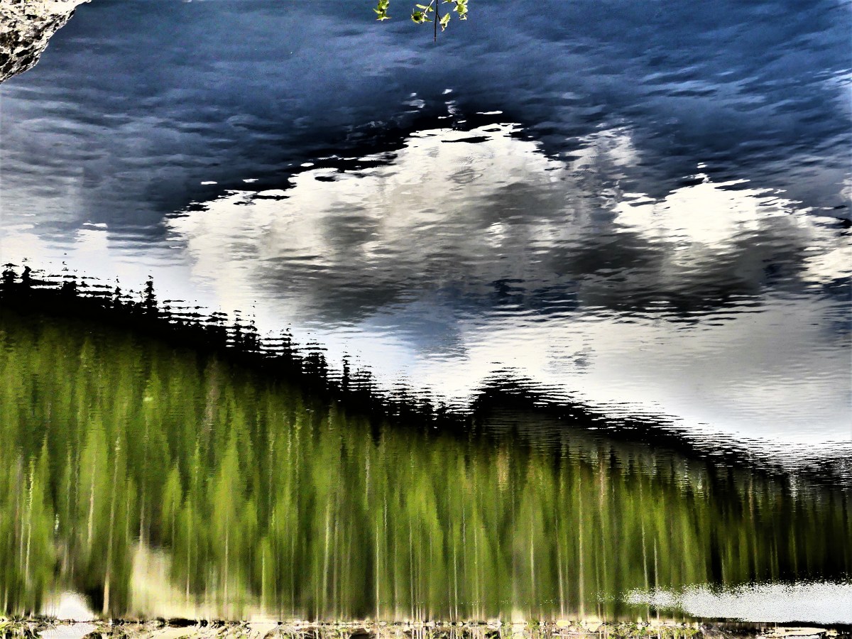
Sixty-eight miles north of Medora lies the North Unit of Theodore Roosevelt National Park. Leah and I had agreed that we would visit the North Unit on our second day. Although not nearly as inconvenient as reaching the North rim of the Grand Canyon–getting to the north from the south was an easy drive.

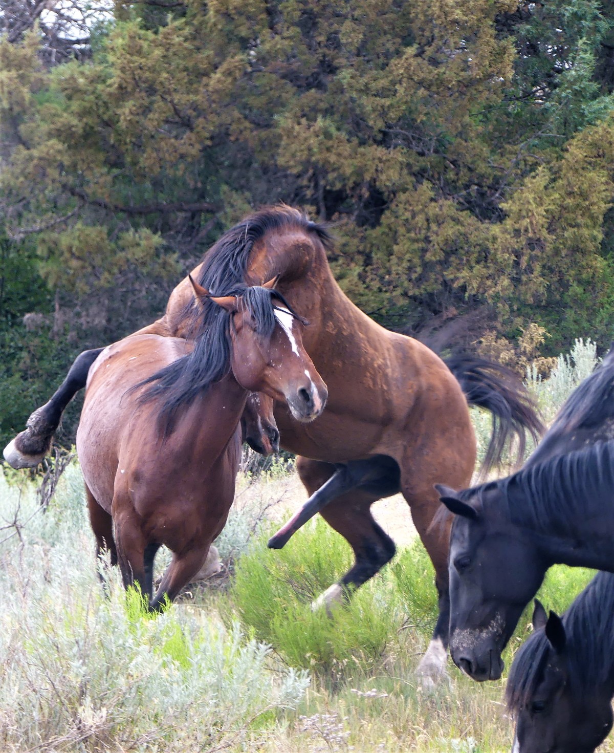
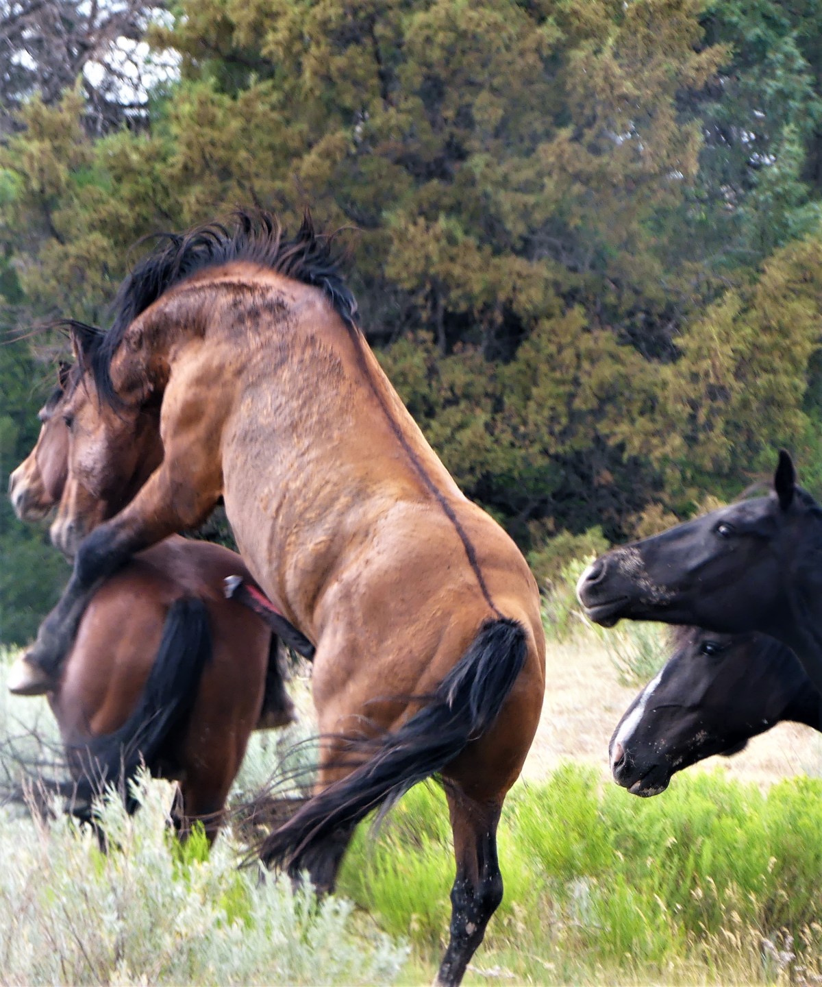
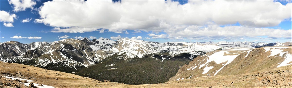
We wondered whether the North Unit of the park could possibly compete with the equine event experienced earlier within the South Unit. Many say the North Unit is more beautiful than its southern counterpart, but that’s too subjective for my tastes. And ranger consensus says there are more animals in these parts, but that’s arguable. And typically, the North Unit sees fewer visitors because its more remote, but today nothing seemed normal. In fact, the day was filled with oddity and  irregularity.

First of all, it’s odd that the two units of the park are disconnected. There’s plenty of fertile land between Medora and Watford City, ND. An infinite carpet of crops and pasture land is periodically punctuated by scattered herds of grazing cattle. But it’s what’s below the surface that really matters.

The Bakken Formation sits between the two park units, and is considered one of the most important sources of oil in the country, having already exceeded 1M barrels a day, and primarily responsible for the 2nd lowest seasonally adjusted unemployment rate across America at 2.5%. Oddly enough, oil derricks are actively pumping at the edge of the park, reaching two miles down and then across two to three miles to tap and sweep through the shale layer that holds the oil.

Active-Wells-in-ND-optimized
Green area represents TRNP and National Grasslands

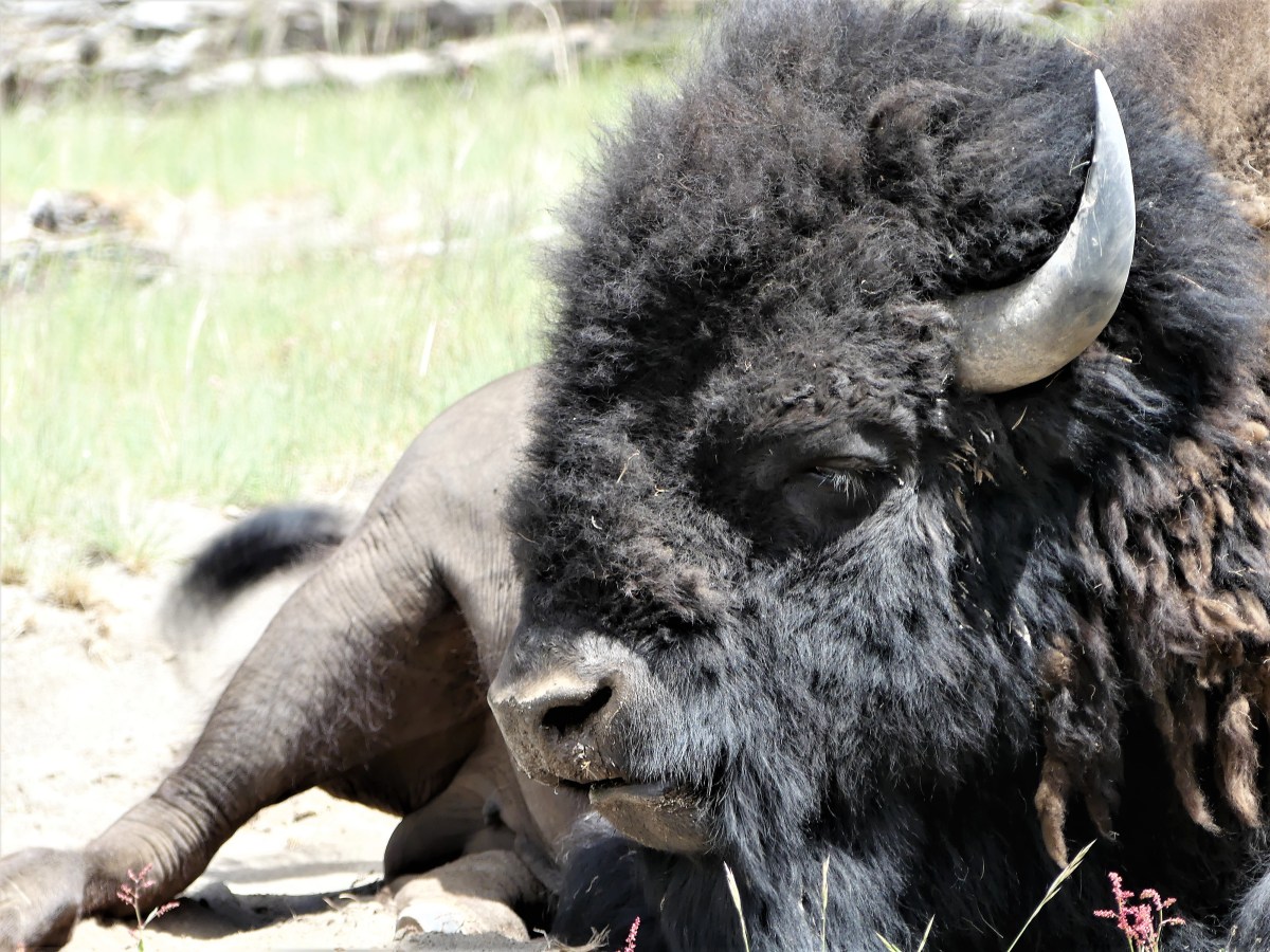
It’s also odd that five miles from the South Unit along I-94 East, the park service operates the Painted Canyon Visitor Center, which also doubles as an interstate rest stop with grazing bison. Weary truckers and families can stretch their legs along a log fence with protected views that will keep them from returning to their rigs.

Painted Canyon Overlook

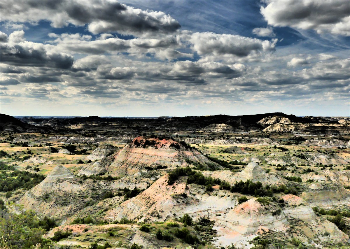
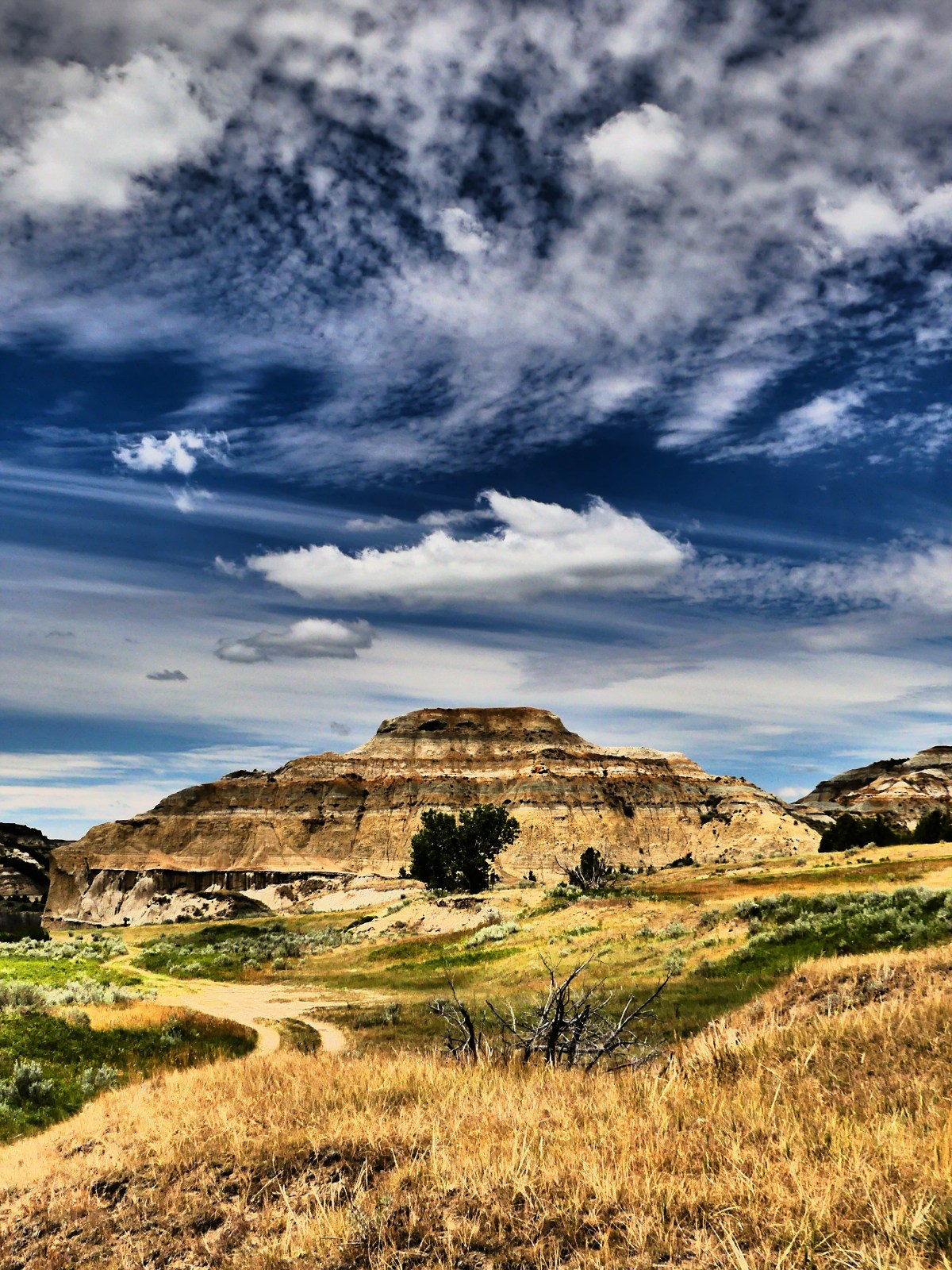
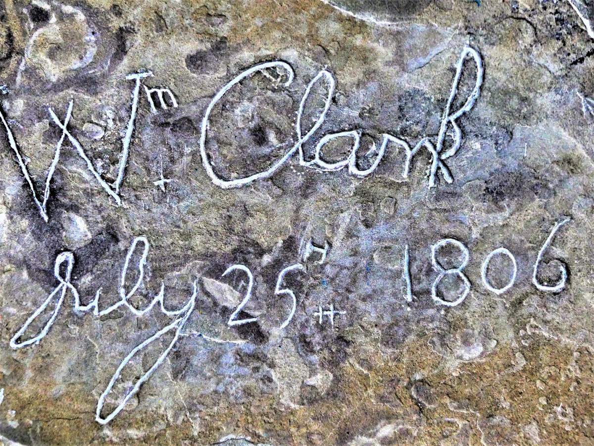
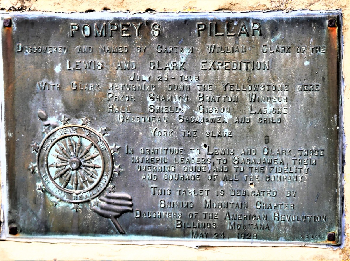
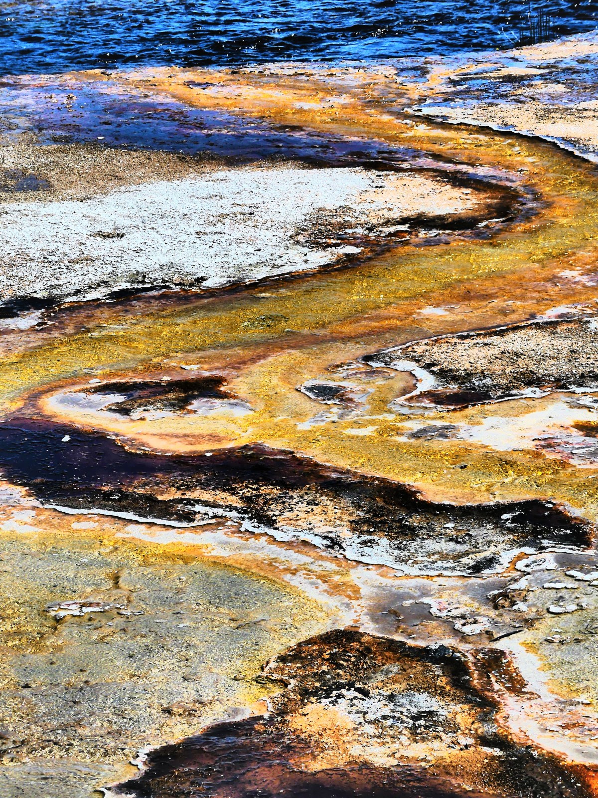
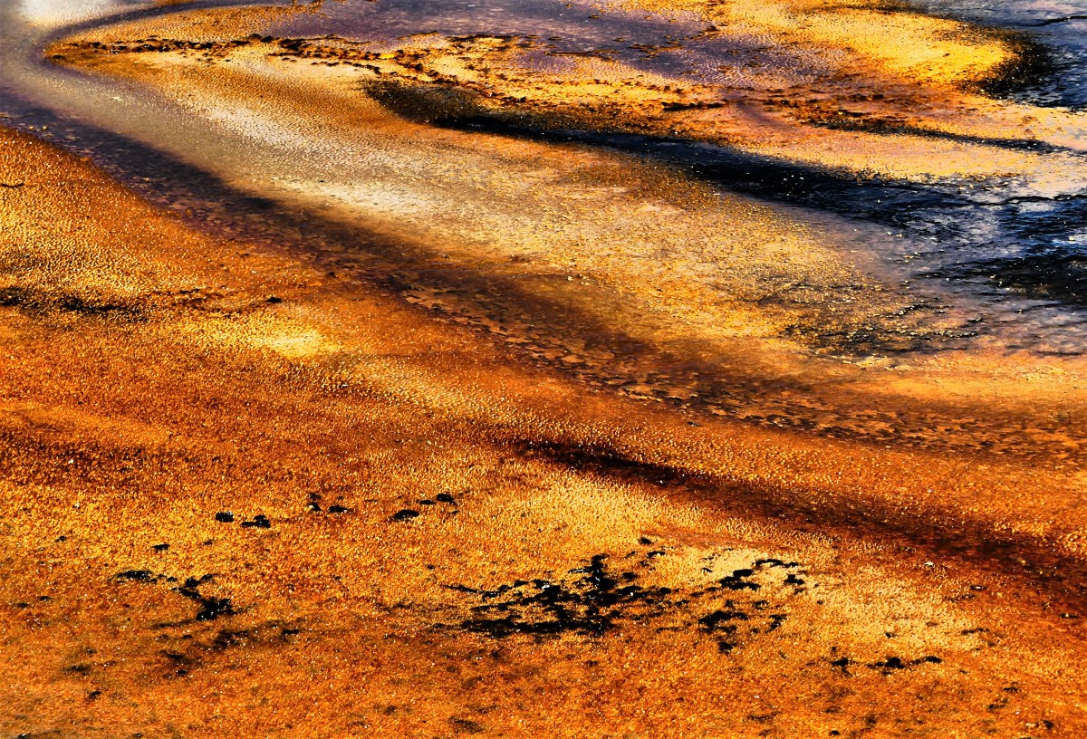
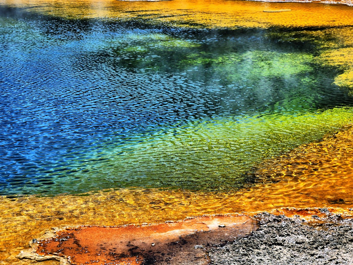
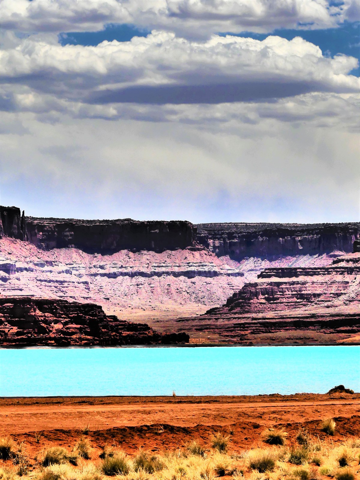
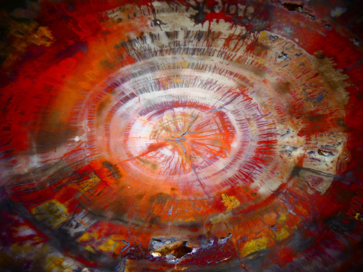
The saturated red hue atop the butte comes from bentonite clay having caught fire from a remote lightning strike. It burned for years, fueled by the coal vein within, eventually turning the clay to brick.

PC butte

Another oddity: the two park units are in two different time zones! After driving north for half an hour, we lost an hour moving from Mountain time to Central time. Thanks to the transcontinental railroad, the southwest corner of North Dakota is caught in Mountain time, while the rest of the state operates one hour later. Nowhere is this more apparent (and confusing) than inside the park, and it’s weird.

Once at the North Unit, we came upon twin trailers taking the place of the regular visitor center. Ranger Jeff explained that “Badlands soil unpredictably shifted from drainage, and caused the foundation to slip and crack.” Consequently, the building was condemned and demolished in 2015, only to be replaced by a double-wide until new construction has been completed. Not exactly inspiring parkitecture.

Jeff and us

Unlike the South Unit’s scenic drive, which loops around for 36 miles, the North Unit road terminates after 14 miles with fewer turnouts. The first half of the road traces the Buckhorn Trail and intersects with Battleship Butte…

battleship butte vertical

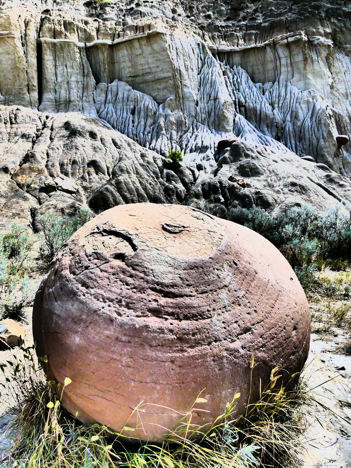
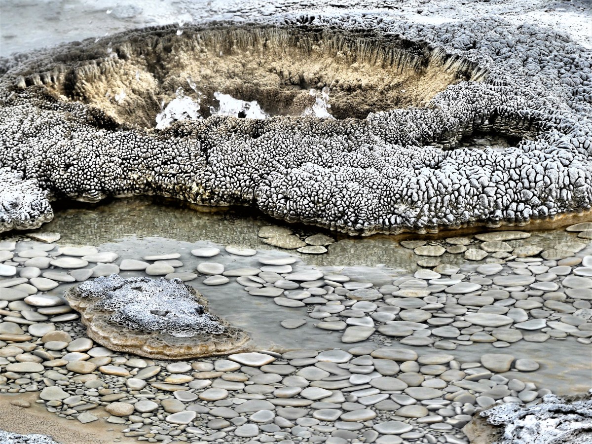
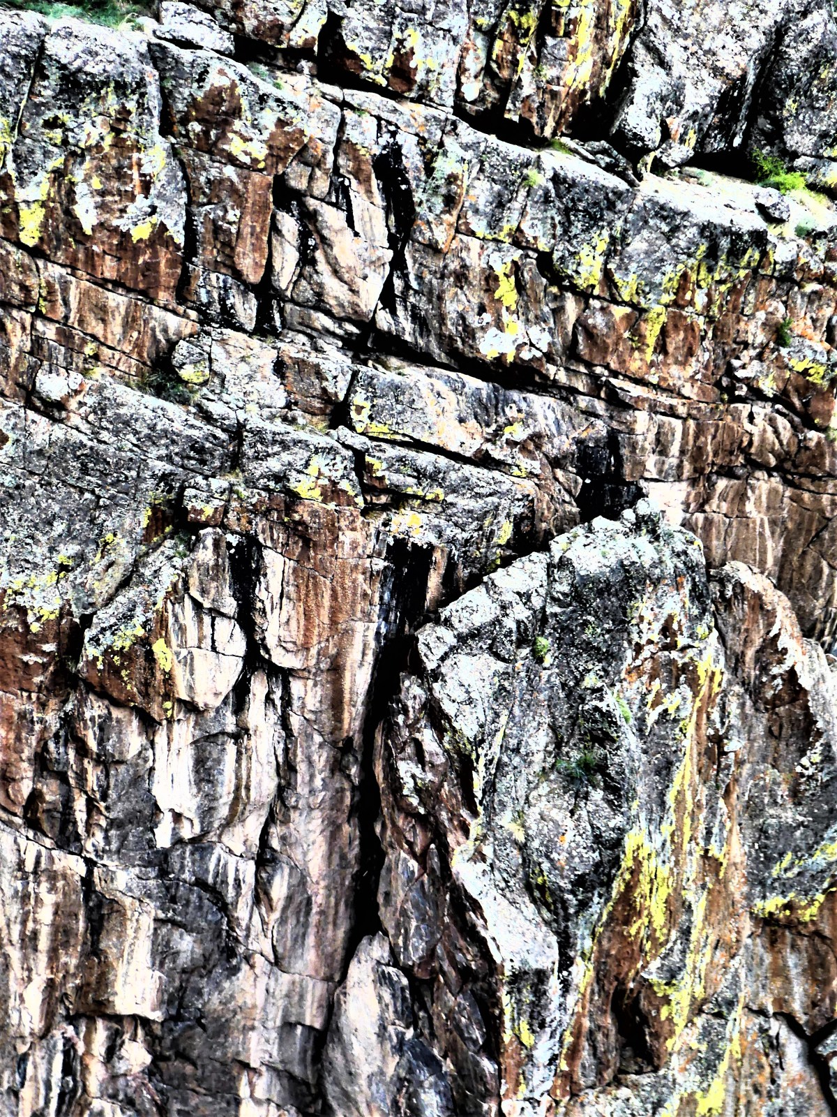
…where round concretions (compact aggregates of minerals leached from Little Missouri groundwater) called “cannonballs” have eroded out of the mountainside and accumulated at the base of the cliffs. I think they’re oddballs and wildly out of place, but nature put them there to be admired.

Concretion

cannonballs

2 cannonballs

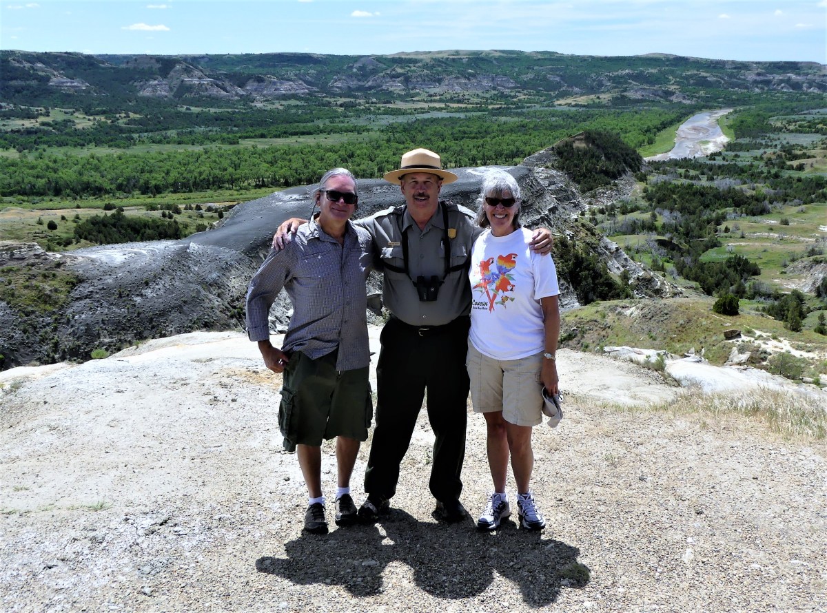
However, the oddest part of the journey was driving 1800 miles from home, only to run into our ex-neighbors at the River Bend Overlook.

Riverbend Overlook

Marjorie and Bruce, who lived just a few doors down the street from us in New Jersey had come to visit her sister Patricia and husband, who live in northeast Montana most of the year, but winter in Delray Beach, FL, around the corner from my dad’s residence–making this the smallest of small-world stories.

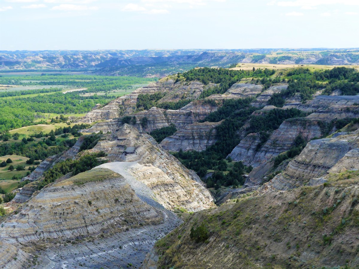
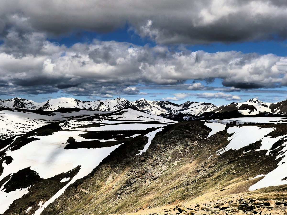
Upon completing the scenic drive to Oxbow Overlook…

Oxbow Overlook

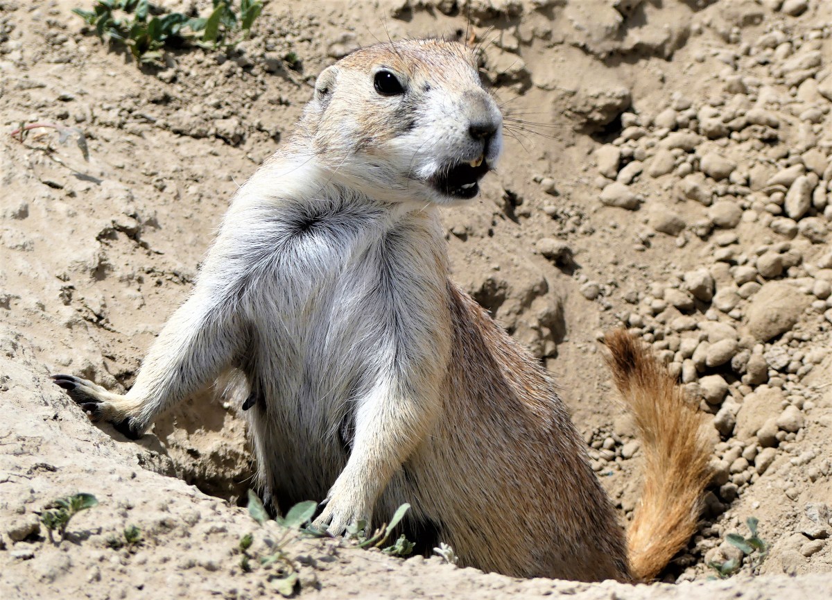
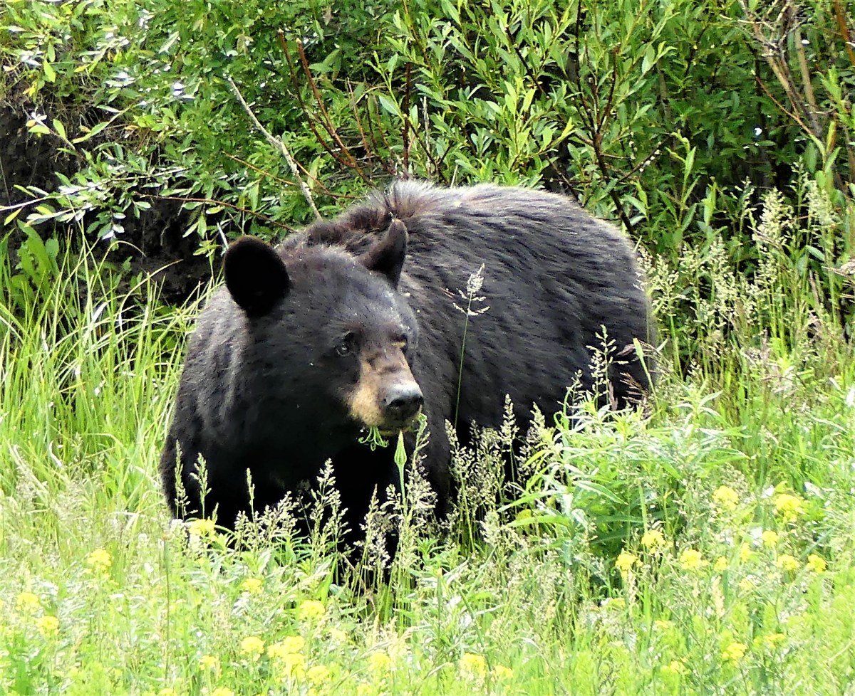
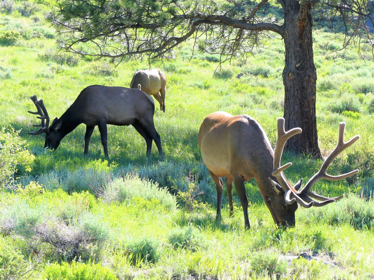
we saw no animals–only traces of what gets left behind. A demonstration herd of Longhorn steer was nowhere to be found; a band of bighorn sheep went missing; there were no elk; and not a single bison was sighted.

From Oxbow, we hiked along a very narrow trail to Sperati Point, avoiding bison poop every step of the way, yet thinking that a photo of bison on a cliff against a blue sky would make a perfect National Geographic cover. But when we arrived, it was only the distant hills before us…

Sperati Point

And that would have to be enough, as we contemplated what’s been normal about our trip up until now.

Gallery

Horsing Around—South Unit

Theodore Roosevelt National Park is a tribute to the man who became a conservationist out of his love for the North Dakota badlands. In fact, he credits his North Dakota experience as early preparation for his ascension to the Presidency. It’s easy to understand Roosevelt’s attraction to the hardscrabble prairie,

prairie pups

prairie dog town look-out

the steep rolling mounds of shrubs and cottonwoods,

badlands overlook

the wrinkled cliffs with ribbons of paint,

coal vein

and the densely populated wildlife that freely roam the roads…

Git along

and plains.

eating and drinking

While not a park that is overwhelming in beauty, it is a park that speaks to the power of preservation, as herds of bison, elk, bighorn sheep and feral horses have been reintroduced to the landscape, and continue to flourish.

getting ready

mounting

oh yeah

Ahhh

She's mine

There is a solitude and serenity that surrounds the rugged territory that originally attracted Roosevelt to the area. Fortunately, the sparse crowd allows the same chance for an immersive covfefe with the wilderness, where the quiet wind carries an energy that seems to rejuvenate the senses and soothe the soul.

Eating Crow

We missed it by one day. The Battle of Little Bighorn lasted for two days, from June 25 to June 26, 1876, but the reenactment only lasted for one day, June 25, 2017. Unfortunately, we arrived in Hardin, MT on June 26. Our neighbors–a retired couple from Illinois living aboard a 2004 Classic Airstream–witnessed the battle scene reenacted with the cooperation and support of Montana’s seven Nation Tribes and a team of 7th Calvary portrayers. Marty and Lil were overwhelmed by the presentation and all the dust. Of course, we would visit the National Monument, but it would seem anti-climatic compared to warplay.

The sky was dark, and rain was in the forecast. It had been two weeks since this area had seen rain, but for us, it’s been dry for five weeks through seven states, so the threat of rain was a welcome way to tame the dust.

The drive to Little Bighorn Battlefield National Monument through Crow Reservation was brief, but insightful. Scores of train cars topped with coal sat idly on the easterly tracks parallel to the the road, while the west side of the road revealed worn trailers and abandoned buildings littered with rusted car chassis. The metaphor was so apropos.

The Crow Nation sits atop one of the largest coal reserves in the country–an estimated 9 billion tons. Yet, according to a report written by PERC  (Property and Environment Research Center),

The tribe’s 13,000 members have little to show for their massive energy reserves. Although half of the tribe’s revenue comes from coal, most of it remains underground. Where development does occur, the process is slow and cumbersome. Unemployment approaches 50 percent on the reservation, and tribal members suffer from high rates of homelessness, crime, and inadequate housing.

Nevertheless, a modern medical center and a requisite casino border the National Monument.

holy rollers

Once inside the Visitor Center’s auditorium, adorned by a 40-foot mural across the entrance,

battle mural

a sobering 20-minute orientation film of the battle was introduced by a 65 year-old retired teacher-turned-ranger who asked a provocative question. “This is a very typical crowd who has come to pay their respects to the fallen on this battlefield–both warrior and soldier alike who had risked everything to preserve their way of life. This was a pivotal moment in our nation’s history, that teaches us so much about our values and ourselves, but when I scan the crowd as I do today, I always ask myself, ‘Where are the young people, and how will we manage to archive this remembrance without them?'”

As we walked through the national cemetery,

cemetary

and along the interpretive trail to Last Stand Hill,

LS Hill

the heavy sky befitted the solemness of the scenery.


sculpture CU

The 5-mile drive between Custer Battlefield and Reno-Benteen Battlefield was a time for reflection about triumph and tragedy, victory and defeat, heroism and humiliation. Yet, lighter moments came from a herd of horses who openly grazed by the road,

horses at restgrazing3 horses

at times defying traffic by staring down cars from the pavement. And when the skies could no longer hold on, it started to rain.

We found shelter at a nearby Crow trading post where Leah and I enjoyed a Crow taco made of frybread. Delicious!

taco

The rain abated by the time we finished our meal. Looking west, we saw blue sunny skies which gave us a green light to further explore our surroundings.

Less than one hour away via Fly Creek Road–a gravel pass connecting I-90 and I-94–we passed rolling ranches of grazing cattle and hay field harvests…

hay field

on our way to Pompeys Pillar National Monument,

Pompey Pillar

a massive sandstone butte on the banks of the Yellowstone River. Regarded as holy ground by the Crow people, the rock also represents the only physical evidence of the Lewis and Clark Expedition. William Clark engraved the wall amidst Indian pictographs on his return trip to St. Louis, and chronicled his 150-foot ascent to the top in his expedition journals.

Clark signature

Clark originally named the rock Pomp’s Tower, after a nickname he had given to Sacajawea’s infant son, whom she carried as she guided the famed expedition to the Pacific. It was later renamed Pompey’s Pillar, and dedicated as a National Monument by Bill Clinton in 2001.

pillar plaque

The hungry and persistent mosquitoes we experienced on the trails were worthy descendants of the “misquitor” that so bothered Clark that he couldn’t see to aim his rifle straight.

Our day of American history ended with another downpour on the drive back to Hardin. But we celebrated the brief moment the windshield was free of bugs, and the chassis was free of dust.

via Daily Prompt: Sunny

Gallery

On Steady Ground, Part 3

Leah and I were breaking up with Yellowstone Park. In the beginning, the park had welcomed us and offered us sanctuary. At times, it made us dizzy with excitement. Despite all the wonderful things the park had brought into our lives (the scenery, the animals, and the natural oddities), there was little doubt that the park was making it hard for us to breathe… most noticably by the basin springs belching sulfurous gas.

From the beginning, it was everything we could ever hope for–the park revealing its majestic views of the mountaintops; the regularity of the geysers; the explosive colors of the basin-bacteria; the rare excitement that only a new relationship can bring. And we were intoxicated by all of it.

It was easy to overlook or forgive some of the park’s flaws during our honeymoon phase: the thinning forests ravaged by fire, the intensity of the water from late winter thaw, and the wildlife fickleness. But none of it matters when you’re blinded by the lushness of the meadows, the clarity of the water, and the immensity of the spectacle.

But somewhere along the line, our relationship with Yellowstone soured. While we knew it was unreasonable to expect monogamy from Yellowstone–knowing that 2.2 million acres should be enough to go around for everyone– we couldn’t help feeling neglected, thanks to all the other visitors who were vying for the same attention.

I feared we were growing apart from Yellowstone. Could it be we were no longer compatible? Were our expectations too high and unreasonable? It’s true there were things we wanted from Yellowstone that the park was unable to deliver. In addition to less traffic and fewer people on the trails, we wanted shorter lines at the entrance gate, and quicker service and lower prices at the restaurants. Was that too much to ask for?

Bottom line, we were no longer getting along. The relationship was too one-sided. Leah and I were putting so much time and energy into the park, and not getting enough back in return. The memory of driving three hours, only to travel thirty miles left us disappointed, and frustrated. The imagined traffic violation from Ranger Painter felt like a “double-cross”.

We felt rejected by the park.

But I was still willing to give the park another chance. I thought that things inside the park could be different if it wasn’t a weekend–when the park wouldn’t be as stressed out. Leah, on the other hand, wasn’t as forgiving. “I’m done!” she announced. “I’m not going back.” She was determined to make a clean break of it.

“But it’s not entirely the park’s fault,” I argued, already suffering from an acute case of separation anxiety. However, in my heart I knew I was covering for a park that had let me down.

Maybe Leah was right. Maybe we should cut our losses, and stop beating ourselves up. We needed to put this abusive relationship behind us.

We agreed that we needed to put some space between us and Yellowstone to give us some perspective. A respite from Yellowstone would help to clear our minds and cleanse our hearts of our frayed feeling towards the park. I was tired of feeling angry at Yellowstone, and I wanted the magic to return.

As with any break-up, it’s always best to confide in a friend to gain clarity. Fortunately, a friend living only 100 miles away from West Yellowstone allowed us to overnight at his two-bedroom condo in Driggs, ID. While it was good catching up with George, it was also gratifying standing under a full-sized shower with constant pressure.

We discussed our soured relationship with Yellowstone over dinner with George, Kate (his daughter), and Kate’s husband Kevin, a full-time fishing guide during fishing seasons. It was an awesome reunion, sitting outside in a restaurant garden setting during the summer solstice.

“Crowded park conditions are to be expected this time of year, considering the park’s popularity,” announced Kevin. “It’s the best water for fishing right now, and it’s where I take my clients. It’s simply the best place to go.”

“I wish we had the luxury to return during a different time of year, but this is the only time we’re passing through,” announced Leah.

“I think that sums it up,” I added. “It’s really now or never. Sometimes you have to give a little to get a little,” I opined, sounding too much like Dr. Phil’s proxy.

The following day, we headed over the Teton Pass into Jackson Hole for bagels. We casually walked through town, bracing ourselves for the long ride through Teton National Park and into Yellowstone.

But we had to stop at Ox Bow for one last glimpse of the austere grandeur of the Tetons.

ox bow 1

By 1:00 pm, we crossed over to Yellowstone’s South Entrance. where an idle gate ranger awaited our arrival. Leah and I exchanged an optimistic glance, unwilling to jinx ourselves by stating the obvious. After a quick bite at Grant Village, we continued around West Thumb, where the road hugs Lake Yellowstone, showcasing its bedazzling blue splendor.

We justified a stop at Mud Volcano to stretch our legs…

mud volcano

buffalo mudders

sour lake

mud volcano bird

…before finishing with a rim trail hike to Lower Falls, and bearing witness to the power of water cascading over a sheer cliff,

Lower falls establishing
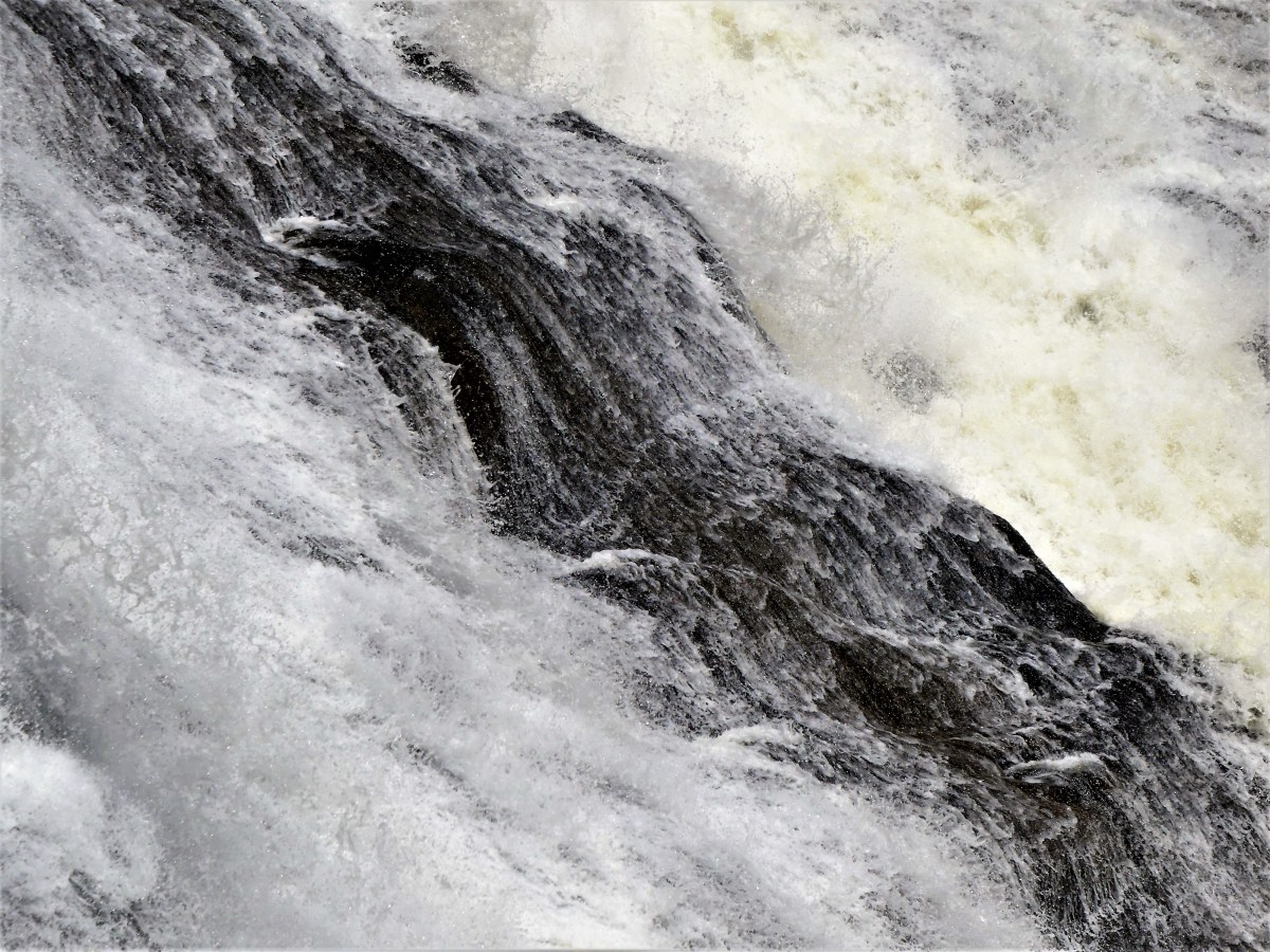
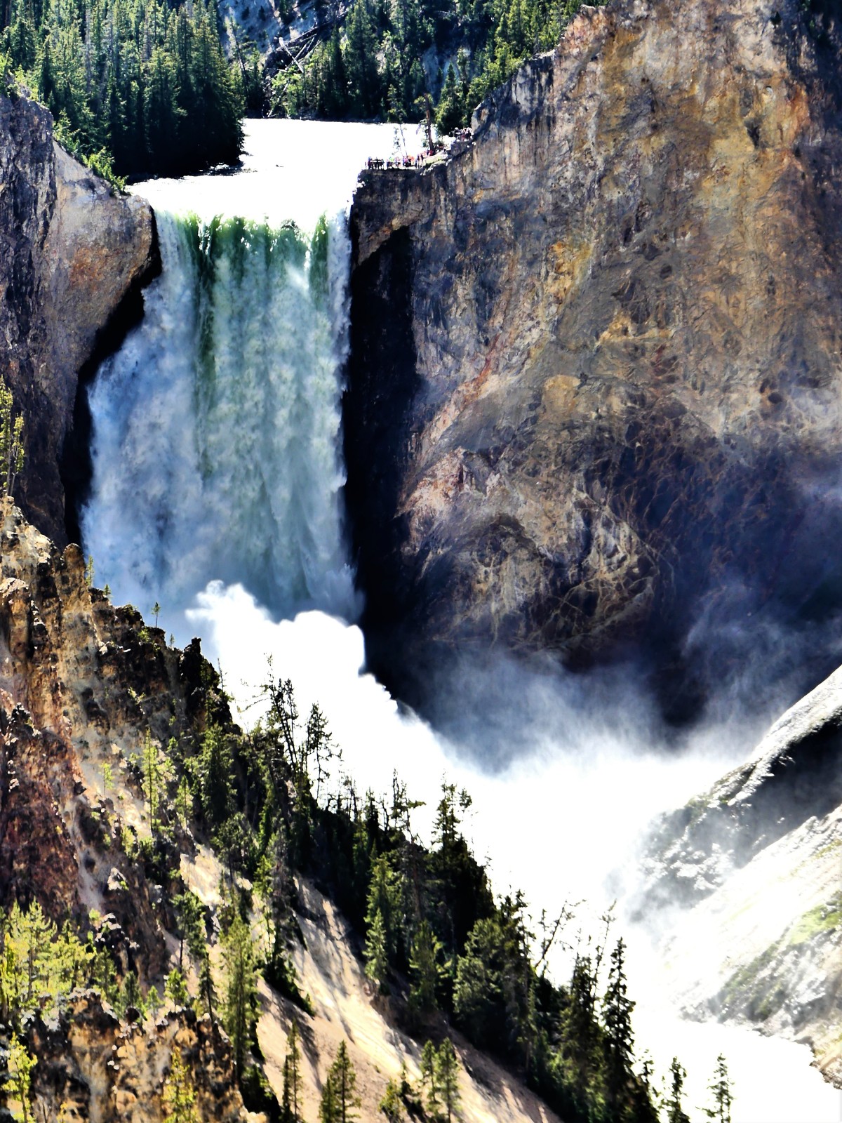
then crashing against the brush-stroked walls of Yellowstone’s Grand Canyon.

Yellowstone was the first National Park signed into law by U.S. Grant in 1872…

and you never forget your first love.

On Shaky Ground, Part 2

(picture credit: UUSS)

Leah and I passed through the construction zone with time to spare, thus avoiding the road closure, and reducing our stress level. It was 7:00 pm, we were tired, and I needed a break from driving since 10:00 am. If we could make it through the next 28 miles without incident, we’d be out of the park and on our way to dinner. We continued toward Madison junction at a normal pace, until once again, traffic stalled to a stand-still.

Cars were pulling over left and right, creating a logjam. The Gibbon River to my left and the foothills of Mt. Holmes to my right offered scant shoulder room to negotiate a roadside pull-over, yet I managed to maneuver the truck clear of the solid white line to investigate for myself.  Just then, a Park Ranger pulled his patrol car behind me with lights flashing.
“Finally,” exclaimed Leah, “there’s someone here to control this traffic mess!”
I dashed across the road to discover a family of elk dining on long grass on the other side of the river, while the ranger seemed powerless to control the many onlookers. Instead, he joined all us at the water’s edge to admire the scene.
Elk and fawns
I turned to ask Ranger Painter a question. “Is there any concern to the public about the earthquake swarm that’s been recorded since the weekend?”
Since June 12, the northwestern edge of the park (our location) had experienced over 464 events, with the largest quake registering 4.4 magnitude on June 15.
Scientists reported,
“This is the highest number of earthquakes at Yellowstone within a single week in the past five years, but is fewer than weekly counts during similar earthquakes swarms in 2002, 2004, 2008 and 2010.”
The last major eruption of the Yellowstone supervolcano was a magnitude-7.5 event in 1959 at Hebgen Lake–the same vicinity experiencing the latest seismic activity–resulting in a landslide that killed twenty-eight people.
Painter responded, “Is that your red F-150 parked over there?”
“It is,” I answered, “but it’s not for sale,” I added.
“There’s been a report about unsafe driving–that you’ve been passing on a double yellow. Is that true?” asked Ranger Painter.
Incredulous, I asked, “Are you sure you have the right truck? There must be a hundred or more red trucks in the park.”
“But your’s is the only one from New Jersey,” he asserted. “Another ranger witnessed you unlawfully passing, and put in a general call to pull you over. That means I’m supposed to give you a ticket from him for the offense. So, I’m gonna need to see your license, registration and insurance card, please.”
“Are you kidding me? This is extortion! There’s no way I did what he said. And if it’s true, then why didn’t your buddy pull me over?” I insisted.
“Look, I understand your frustration, and I don’t think this is the best way of doing things either.” Painter shrugged, “Personally, I hate doing someone’s dirty work, but I’m just the messenger. This is gonna take a little time, so you’re welcome to continue taking pictures if you want.”
After twenty minutes, the elk returned to the forest, and the crowds diminished. Painter returned to the truck, with my citation. “First of all,” he started, “I want to thank you for not being a jerk.”
“Not my nature,” I declared.
“Good,” Painter responded, “because I didn’t cite you for careless driving like the other ranger advised, which would have been a $200 offense. Instead, I wrote you up for unsafe passing, which only carries a $60 fine… and a $30 processing fee.
“What? A $30 processing fee on top of the ticket. You guys give new meaning to highway robbery,” I alleged.
“What can I say? Everything’s going up,” Painter posited. “Just sign at the bottom,” he instructed, offering the violation notice. “I’m also giving you this flyer, ’cause if you think this is unfair, then call the number and maybe you’ll get the ticket dismissed if you fight it.
“You bet I will,” I pronounced.
“Drive safely,” Painter forewarned, “and you’re in no danger of being caught in an earthquake.”
We finished the ride home to our Airstream in West Yellowstone without words or further incident after completing the Upper Loop in 10 exhausting hours.
The next day, we planned to follow the Lower Loop around, but we were grounded the moment we passed through the West Entrance. Our intention was to leave for the park on the earlier side of 9:00 am, but arranging future reservations in Canada’s national parks had proved more elusive and time-consuming. Consequently, traffic into the park was such a snarl by 10:30 am that cyclists with loaded side bags were making better time. After three hours, we managed to travel thirty ebb-and-flow miles. We were so far behind the tie-up that we could never figure why things were moving so slowly, although we surmised that it was animal-related.
We ate our lunch at Fountain Paint Pot, and walked the boardwalk through a desolate field of fumaroles, geysers, and hot springs, glad to finally stretch our legs. I chose to photograph the landscape as “abstract in nature”, sometimes compressing depth with a longer focal length…
blue flats
Fountain Paint Pot flats
bacteria trail
bacteria swirl
…or extending time by shooting at high speeds…
mudpots
mud pop
…before moving onto Black Sand Basin to capture and accentuate true color through a polarizing filter.
Norris Geyser Basin
 emerald hot spring
prismatic pool
Leah and I agreed that it made little sense to continue the loop. It was already 4:30 pm. We called it quits before reaching Old Faithful, knowing full well that we would be driving into the eye of traffic turmoil, and realizing that the ride back to West Yellowstone could be unpredictable.
We originally planned to explore the park in five days, by pacing ourselves through the highlights, but allowing for a deeper connection by hiking some of the 1000 miles of available trails. But the Yellowstone crowds squashed our enthusiasm, and wore us out. Leah vowed that we would not return to the park in the foreseeable future, even through two more days were scheduled.
Part 3 reveals how we spent the remainder of our time.

On Shaky Ground, Part 1

via Daily Post: loop

I know I’ve complained about crowd size at National Parks before, but now that summer is upon us, and we’ve arrived at Yellowstone, it seems as if this park is bursting at the seams. Today, we abandoned our plans to visit the Upper and Lower Falls of Yellowstone’s Grand Canyon because of traffic, and we’re not returning tomorrow.

We started out four days ago, driving to Yellowstone after an overnight stay at Colter Bay in Grand Teton National Park. Unfortunately, the campground was at capacity, without any opportunity of staying an extra night… and we would have stayed had there been a cancellation, despite the broken water valve at our site. (Leah negotiated a $5 discount for the inconvenience.)

It meant there was little time to explore, given our late arrival after driving five hours from an overnight at Rawlins, WY, a whirlwind dust-bowl of a town that features the Wyoming Frontier Prison, a retired state penitentiary-turned-museum as its biggest distraction. Sorry, but we had little interest in “doing time” at a prison.

With limited daylight at Grand Teton, a hike around a portion of Jackson Lake was all we could muster.

Flowers and TetonsLakeviewmoored boats

The transition between Grand Teton and Yellowstone is seamless, with the South Entrance serving as the gateway to both parks along the John D. Rockefeller Memorial Parkway.

Although we were towing the Airstream through the park to our West Yellowstone campsite, we elected to stop at Old Faithful to stretch our legs with a few thousand others.

old faithful crowd

But it was worth it!

people watching eruptionInside Old Faithful

After an abbreviated walk along the Upper Geyser Basin with half the population of China, we decided to call it a day. The setting and throngs of tourists left us uneasy to a “fault”.

UGB6Upper Geyser BasinUGB2UGB4

Arriving at Wagon Wheel RV Campground, an open over-crowded sand pit in West Yellowstone presented its own set of problems. Our designated reserved site had been cut in half. What was once a long splinter of space that would barely accommodate a pull-through trailer with tow vehicle, had now become two sites. Our front-side neighbor pulled through yesterday, leaving me the compromised backside of the plot to back into from the street.

back to back

It was like threading the Airstream through a narrow tube, backwards.

tight

Leah was furious. With no other available space anywhere in the park’s vicinity, we accepted our fate, but not until Leah wrangled a $20 discount for each of our five nights.

The next day, we completed the 70-mile Upper Loop.  Our objective was to take the counterclockwise route to avoid early road construction delays between Norris and Mammoth Hot Springs. To complete the loop, we would need to leave Mammoth by 6:30 pm before the construction crew shut down the road. It took us ten hours to make the circle, but gave us many unexpected thrills.

full bisonBison profile1

We followed the road past Gibbon Falls,

Gibbon Falls LSGibbon Fallsmuddy water

to the Norris Geyser Basin,

Norris prismUGB1

where an Oregon idiot dissolved to death last year by slipping into a boiling spring. Apparently, he and his sister carelessly wandered 225 yards of the boardwalk trail near Porkchop Geyser. The Norris region is home to the oldest and hottest geothermal activity in the park.

smoke and water

There were no remains to recover.

flames.jpg

Our leisurely drive continued uninterrupted, winding through numerous mountain passes and rolling meadows until traffic slowed to a standstill near a swarm of pedestrians who blocked the road with their vehicles parked and running. Parents with children were dashing across the road, weaving through an impromptu parking lot and up a knoll overlooking a valley. I managed to park the truck 50 yards away at a turn-in, and ran with my camera.

black bear dinnerbear2bears

We arrived at Mammoth Hot Springs by 6 pm as the bright sun was casting tall shadows against the terrace wall.

terracesUGB5Mammoth HS terrace1 (2)Mammoth HS terrace

Time at the top of the park was limited. Our newest concern was getting back to West Yellowstone before the road closed. Most of the way back was a work zone, with alternating one-lane traffic slogging through packed dirt until we reached the Norris junction.

That’s when things got strange…

Part 2 coming soon.

Rocky Road National Park

With so much attention being paid to the over-crowded conditions at National Parks this year, Leah and I were optimistic that Rocky Mountain National Park (RMNP) would allow us some breathing room—despite a doomsday article recently published by Denver Post that boasted a 21% increase in visitor attendance at RMNP over the same month last year (Denver Post). According to the NPS, more than 1 million people will make RMNP their vacation destination in the next six weeks and that does not bode well for the visitor who comes to enjoy the park.

Apparently, when Trump announced a federal hiring freeze one week after taking office, the park was unable to move forward with seasonal hires, leaving the Park Service unprepared to staff its most popular and profitable parks. Additionally, there was no budget allowance for background checks and bonding of future employees, which has translated into longer lines at Park Service admissions, and fewer transactions at Park Service Conservancy Nature Stores. Penny-wise, pound-foolish economics!

We arrived in line at 1pm on Monday. After half-an-hour, we crossed the threshold into RMNP. Signs were posted along the way announcing full occupancy at all campgrounds. I felt fortunate snagging a camp-site for three nights at Glacier Basin—a no-services facility—through the NPS reservations web-site over six months ago.

I produced my Senior Pass credentials to the ranger at the gatehouse, and received an obligatory park map, but not a newspaper, because the official newspaper of RMNP had run out before noon. The newspapers are a vital resource to the park’s success, given the hands-on information that visitors rely on when planning their stay, notwithstanding: safety protocols, hiking trails, shuttle bus schedules, ranger-led programs, road and trail conditions, and visitor center(s) hours of operation.

After unhitching the trailer, Leah and I elected to tour the north side of the park, following the Trail Ridge Road to the Alpine Visitor Center,

rainbow curve
Rainbow Curve
forest canyon panorama
Forest Canyon
Iceberg Pass Panorama
Iceberg Pass

and past the highest point of any NPS road (12183 ft.).

Gore Range 2
Gore Range
Gore Range
Medicine Bow Curve

Several look-outs along the way provided ample opportunities to be blown about by sustained winds of 50 mph, admire wide-open views of nearby mountain ranges in the blistering cold, and escape from the occasional driver who negotiates a hairpin turn while pointing a camera outside his window.

With such a high number of drivers who suffer from altitude stupidity, it’s a wonder there aren’t more accidents like the one we came across that closed the road for an hour until a tow-truck arrived to cart away the collision. It’s also a special breed of driver who comes to the park and thinks it okay to stop in the middle of the road to observe a crowd watching something off the side of the road.

3 elk

elk portrait (3)

Sadly, it’s probably the same driver who lollygags at 18 mph, when all the vehicles trailing behind are aching to achieve the 35 mph speed limit. It’s as if people have come to the park to practice their driving, turning the roads into a fright of passage.

While it was difficult to completely avoid the road toads, Leah and I managed to steer clear of much the traffic tie-ups by exploring more remote regions of the park during our three-day visit. One 7-mile hike on the edge of Grand Lake took us to the top of Cascade Falls,

Colorado River

where so much run-off from late snow had produced a torrent of moving water.

Cascade Falls1

moving water

Drainage from the Ptargiman Mountain was becoming an issue, so a crew was dispatched to redirect the spill over from the falls.

llama

The next day, a 5-mile hike off the Moraine Park spur led us to Cub Lake in the shadow of Steep Mountain.

cub lake

Considered an easy hike by the trail guide, Leah was unconvinced by the steep rocky incline to the gorge—narrow and muddy, and shared by horses—which led to lots of side-stepping.

trail horses cub lake

Not to be deterred, Leah would lobby for a label that was more suitable. After following the half-mile loop around Bear Lake, one of the park’s most popular subalpine locales–distinguished by its late thaw,

bear lake with mountains

and smooth-as-glass lake surface–

reflection

Leah stopped to ask a ranger’s opinion of the Cub Lake Trail. To Leah’s delight, the ranger agreed that the hike should be upgraded from easy to moderate, but only because of its duration.

The thin air and jaw-dropping views of mountain peaks, canyons, snowfields, lakes, meadows, falls and forests left us breathless. But we came for the animals as well. We waited patiently for nearly an hour at Sheep Lake with the hope that the park’s bighorn sheep and their lambs might descend from the mountain to graze and lick mud in the meadow below. The timing was right—no coyotes were spotted at the pond—but the sheep had other ideas, and stayed where they were.

But there was no shortage of chipmunks, squirrels and marmots.

RMNP is a delicate ecosystem that has been managed since 1915. With so many visitors eager to pilgrimage to the park, the importance of preservation and land stewardship along with proper funding will drive the next one hundred years, provided Sunday drivers stay off the roads.

Drop-Dead Gorge(ous)

After spending eleven days exploring “The Mighty 5”, I believe I’ve inhaled enough red dust to qualify for the first NASA Mars mission. Utah’s red dust had infiltrated everything, leaving a veiled matte finish on every surface: inside the Airstream, inside the truck, inside our undies, and inside our lungs. Leah and I were more than ready to move on to Colorado’s cool, crisp mountain air. Or so we thought…

We also thought we were leaving the heat behind, but unseasonable high temperatures followed us across state lines, where records have been set. All we’ve heard thus far, is “It’s not supposed to be this hot until July and August.” And at the other extreme, ski resorts in Utah and Colorado have experienced a late spring ski surge, with the Rockies holding onto three feet of snow that fell three weeks ago, resulting in officials closing the east side of Rocky Mountain National Park, and posting avalanche warnings throughout the high country. If only the climatologists responsible for this hoax would go back to being less fake, then the rest of us would know how to prepare for normal weather.

Nevertheless, our first stop in Colorado has been encouraging, thus far. During our stay, the temperature at Black Canyon of the Gunnison National Park reached eight degrees over average for this time of year, which translated into a comfortable 90°F for us, down from customary triple-digit readings we endured while in Utah. It meant we could sleep with open windows at night, although it left us vulnerable to drifting cigarette smoke, and prone to a crying baby, a chatty family, a barking dog, and an occasional late-night motorcycle arrival.

Our visit to Black Canyon of the Gunnison National Park afforded us two different perspectives: from atop the rim…

silhouette

and the water’s edge.river view

The scenic road above follows a serpentine road with several stunning overlooks that highlight dramatic changes in the cliff face,wall detail

wall colors
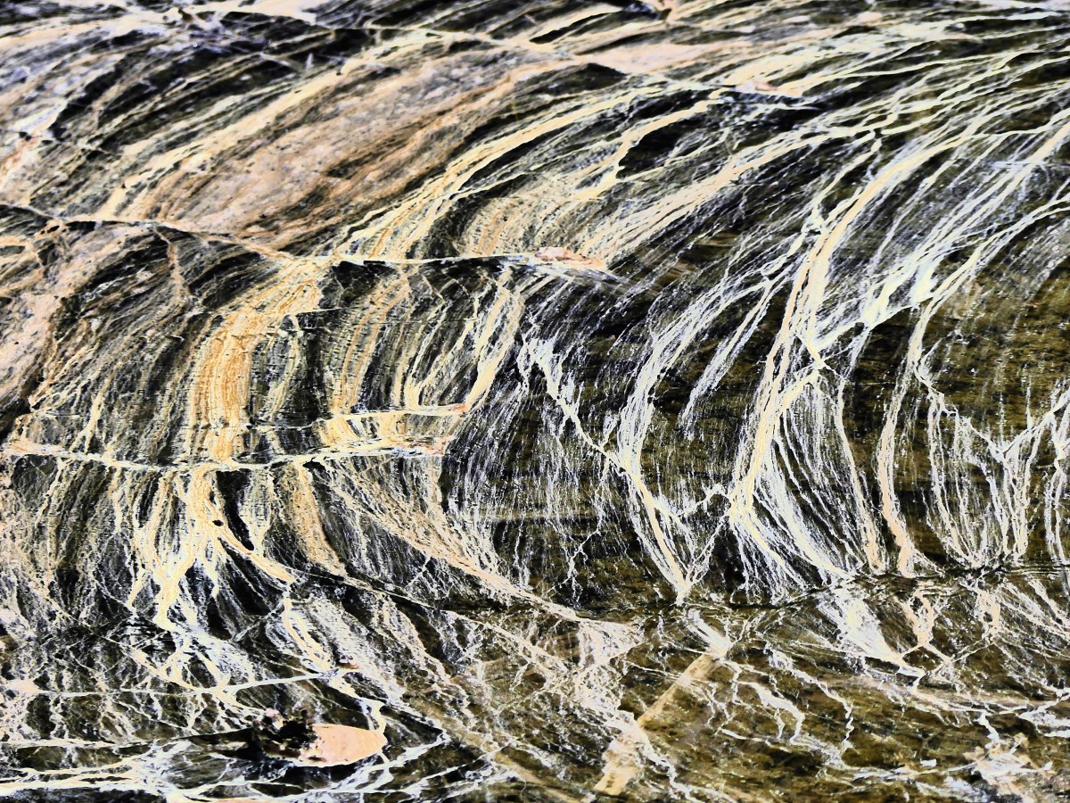
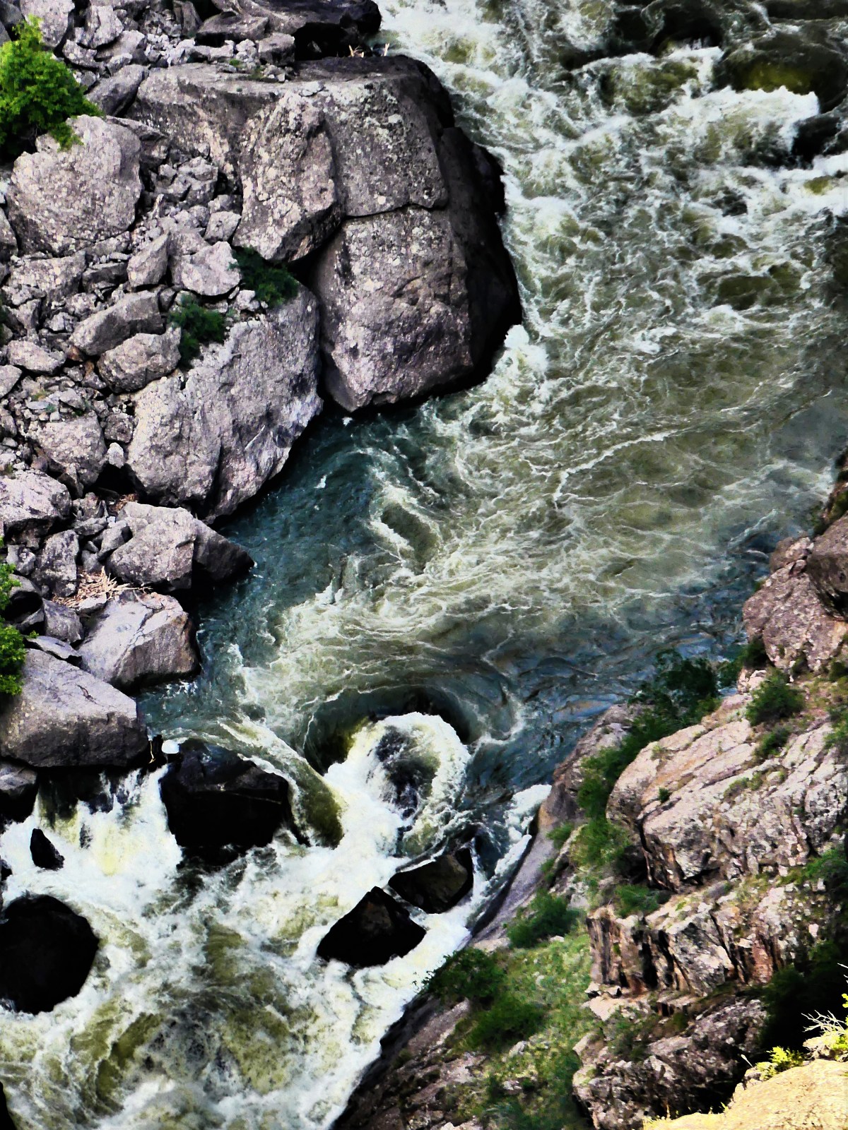
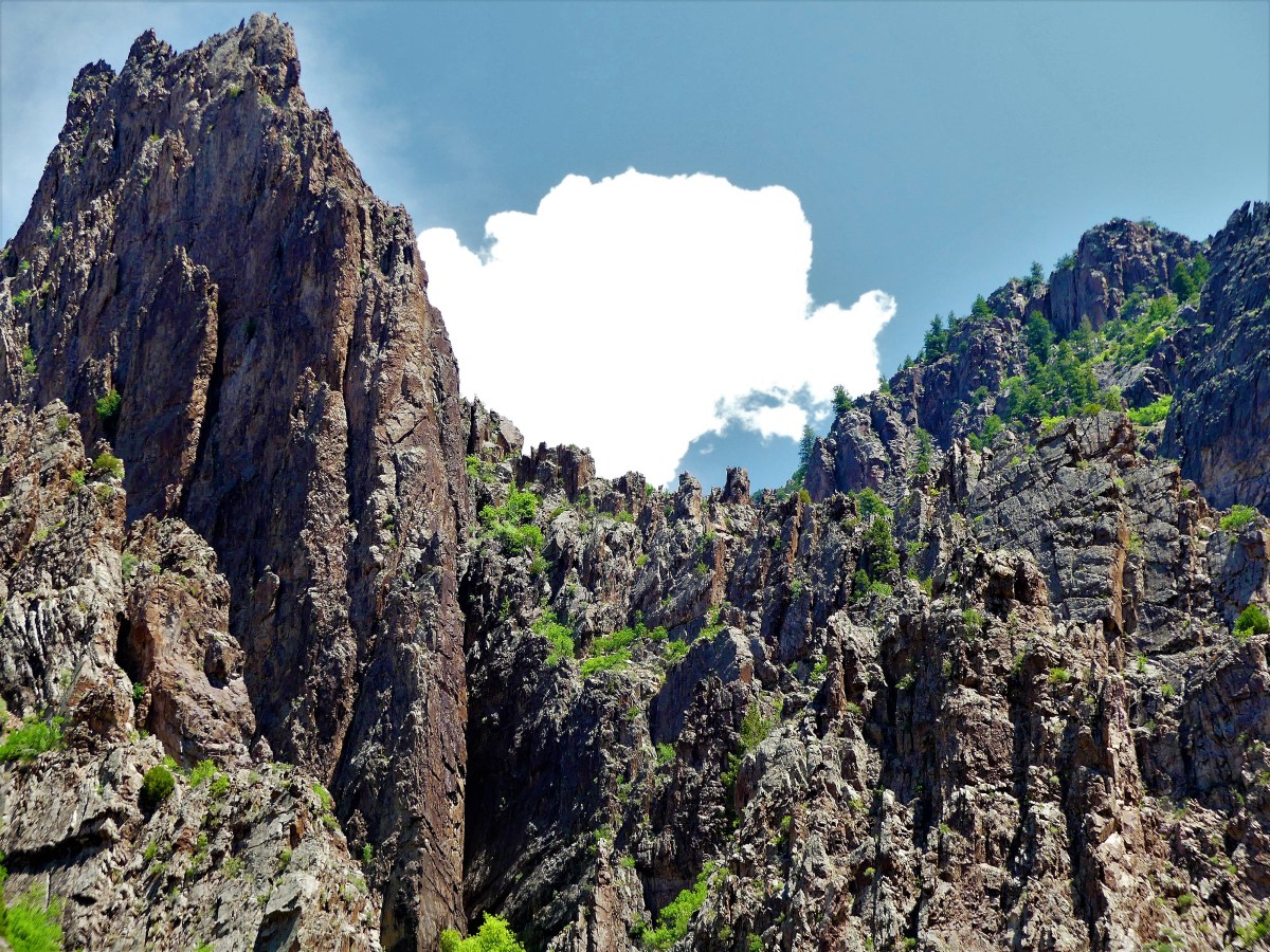
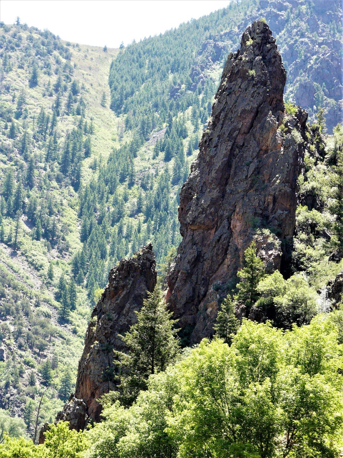
as the roar of the Gunnison River echoes against the sheer walls of gneiss and schist.

long view of canyon

painted wallfissuredragon point
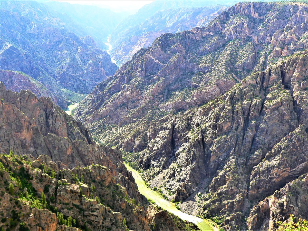
The river’s pivotal role in carving out 2 million years of metamorphic rock has resulted in canyon walls that plunge 2700 vertigo-inducing feet at Warner Point into wild water that has been rated between Class V and unnavigable.

Gunnison River down the canyonCU Gunnison rapidsThe view at Dragon Point showcases brilliant stripes of pink and white quartz extruded into the rock face, personifying two dragons who have symbolically fused color into a somber Precambrian edifice.dragon wall

The view from the bottom up accentuates the towering spires laced with lush and vivid flora.ridgelinespiresridgeline1and focuses on an untamed water system that’s required three dams to slow the erosion of the canyon floor.

Ford and dam
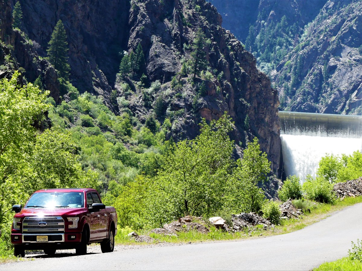
According to Park Service statistics, left unchecked, the Gunnison River at flood stage would charge through the gorge at 12,000 cubic feet per second with 2.75 million-horse power force. Dams now provide hydroelectric energy, and have created local recreation facilities for water sports, including Blue Mesa Reservoir, Colorado’s largest body of water.

Black Canyon can be seen in one day, but a drive to the Curecanti National Recreation Area, 50 miles away, can easily turn into a two-day love affair with solitude and wilderness.

Holes and Dicks

I already know what you’re thinking, so let’s address the white elephant in the blog room. Yes, the title is definitely suggestive and maybe controversial, and some would presume the blog post content is bound to be risque or even perverse. Some of you may also think that by titling a blog post with a gratuitous sexual innuendo, I am pandering to readers, trying to lure them to my blog site, feeding their “let’s-just-see-what-he’s-up-to” curiosity.

And I’m okay with that. But what if I told you that the blog caption is really about Arches and Canyonlands National Parks? Because everywhere you look across the landscape, it’s either a yoni or a phallus of varying shapes and sizes–sometimes alone, and sometime together. Need proof? Arches first…

then Canyonlands…

I can think of two factors that put both parks in perspective.

First of all, both parks are almost next door to each other, separated by US-191 and thirty minutes apart. Imagine two National Parks being that close to each other without touching–making it possible to visit both parks in one day, but highly unlikely that anyone would have the stamina. It’s such a tease. It’s as if there’s a tantric energy between the parks.

Secondly, let’s take a look at the actual names given to each of the park’s attractions. Canyonlands is considered a backcountry mecca for campsites–some of which are called: White Crack, Potato Bottom, Candlestick, and Gooseberry (a cult aphrodisiac). Similarly, Arches has provocative names for its formations. For example, there’s The Organ, Garden of Eden, Fiery Furnace, and Double O Arch, just to name a few.

It’s not my imagination that almost everywhere around the parks, the sexual iconography is omnipresent. And then labeling the sites with sexual references is equally disturbing. So calling this post “Holes and Dicks”–while seemingly derivative of two national parks–is highly accurate, given the evidence.

However, beyond the Hieronymus Bosch backdrop, a landscape exists that can only qualify as other-worldly.

From Canyonlands…

Buck Canyon formations

crater detail (2)

gooseneck overlook panorama

Green River detail

Potash basin

potash drive

and from Arches…

Courthouse

Park Avenue

DA1

Balance Rock

South Window

However, returning to “Holes and Dicks”, another interpretation exists which is equally as worthy of consideration, and perhaps more significant.

While photographing the Turret Arch,

Turret Arch

I noticed unusual activity at the vortex and eye of the edifice.

climber and carver together

A small group had willfully climbed the structure despite explicit warnings, but my eye was on the “dick” in the red shirt, who had climbed inside the “hole”.

dick in hole

He seemed to be focused on the wall of the hole, but it wasn’t entirely clear to me until I zoomed in as far as my lens would allow…

carver detail

and realized that this shmuck was defacing the arch. I was livid that this putz would disrespect a 350 million-year-old shrine by carving his name into the sandstone. I felt like I was caught in the middle of a “What Would You Do?” moment. I scanned where I stood to see if anybody else had noticed, but John Quinones was nowhere in sight, and I had the only window to this dick’s desecration.

I showed Leah the photos after returning to the F-150. “Are you fucking kidding me?” she exclaimed. “You need to show these to the park ranger!”

She left the truck, and wrangled the ranger assigned to traffic control to the driver side of the truck to view the incriminating evidence. Despite the glaring sun, he saw enough of what he needed to see to dispatch a call to park law enforcement on his radio He pleaded for us to stay, while apologizing that our vacation might be inconvenienced by waiting for the officer in charge.

Ten minutes later, Officer Busbee arrived, reviewed the photographs, and determined that they were essential to prosecuting the individual. I volunteered to email the files when able, and we were on our way back to the Airstream.

Downloading took longer than expected given such a weak signal (see Indebted to the Internet), but eventually the email was sent:

Dear Officer Busbee,

I hope these pictures are of service to you.
I’m a firm believer of protecting the legacy of National Parks for future generations,
and take offense when others spoil or jeopardize their preservation.
I trust you will keep me in the loop regarding the status and disposition.
Sincerely,
Neal Lubetsky

All I could do was await a response, which arrived the following day:

Hello, Mr Lubetsky,

Thank you for the photographs.
Unfortunately, we were unable to make contact with the violators.
I appreciate your concern for the Parks.  They are indeed very special places that are preserved for all to enjoy, now and in the future.
Thank you again.
Kindest regards-
Michelle
~~~~~~~~~~~~~~~~~~~~~~~~~~~~
While it was disappointing that the vandal got away, I felt vindicated in my effort to stop him from diminishing the importance of what the Park Service represents.
I trust my story justifies the title, but still, you’d have to admit that the scenery is provocative, and it is a worthy backdoor strategy to introducing other readers to my blog.

A Park By Any Other Name*

If you could mix Sedona’s red rocks,

chimney rock
Not Sedona–Capitol Reef
scenic hwy1
Not Sedona–Capitol Reef

with Painted Desert’s colors,

capitol reef
Not Petrified Forest–Capitol Reef
rock faces
Not Petrified Forest–Capitol Reef

and Zion’s canyon walls,

canyon walls
Not Zion–Capitol Reef
scenic hwy canyon wall1
Not Zion–Capitol Reef

and Canyonland’s monoliths,

monolith
Not Canyonland–Capitol Reef
chimney
Not Canyonland–Capitol Reef

while also adding Arches’ arches…

Hickman Bridge1
Not Arches–Capitol Reef
hickman bridge2
Not Arches–Capitol Reef

in a geologic blender, then stir in one cup of Fremont River water,  Fremont River

top with orchard fruit,Capitol Reef orchard (2)
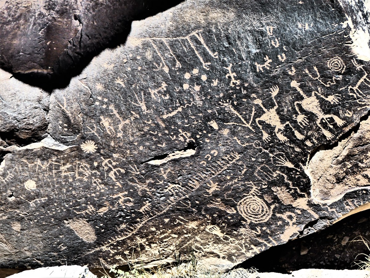
sprinkle in some petroglyphs,

and season with Mormon history,school house (2)
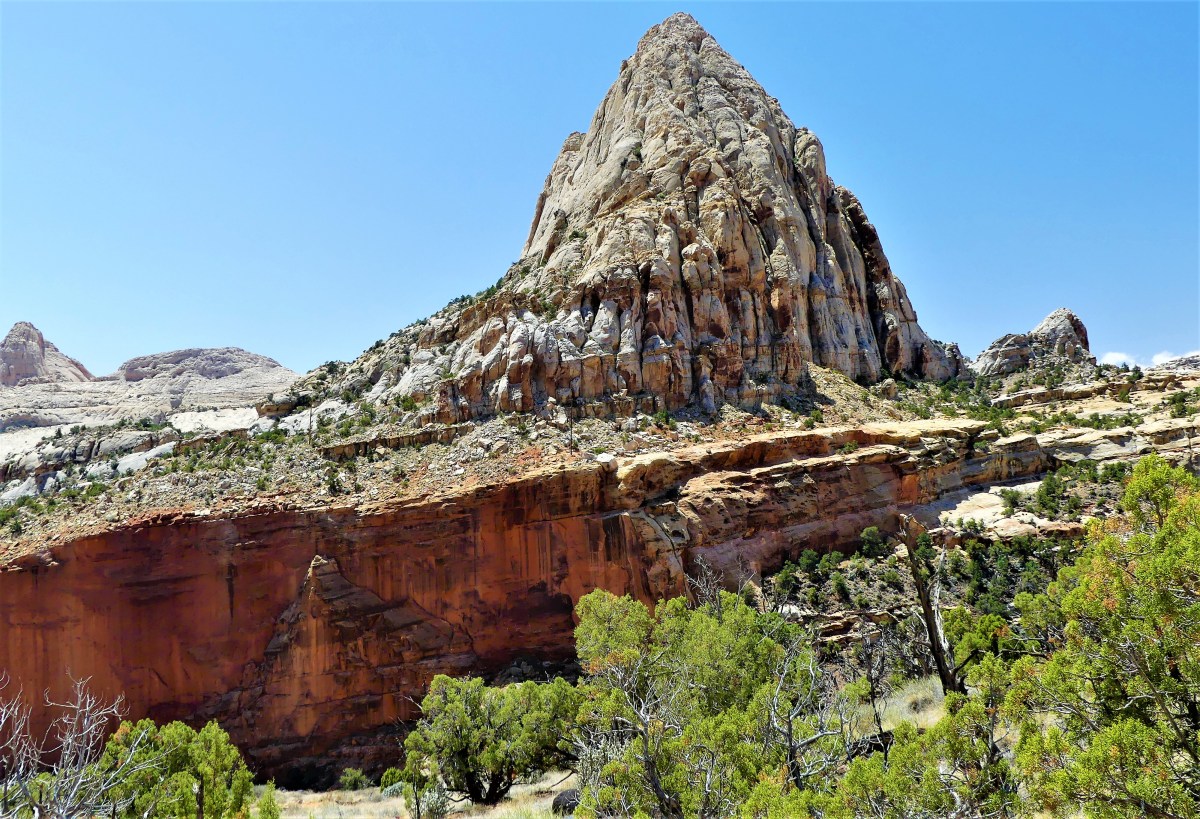
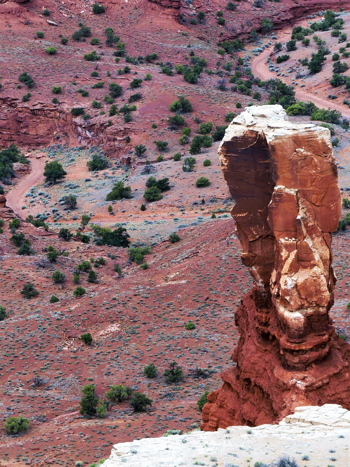
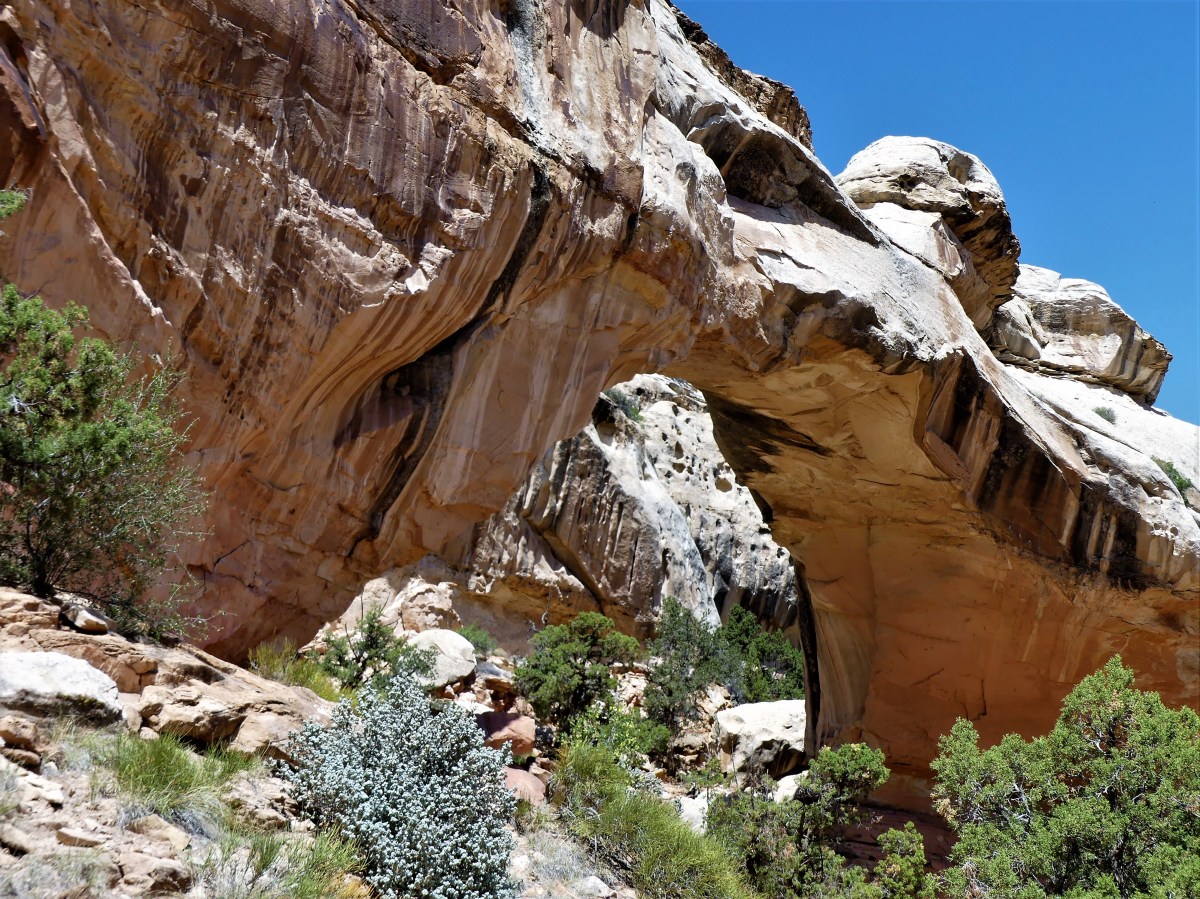
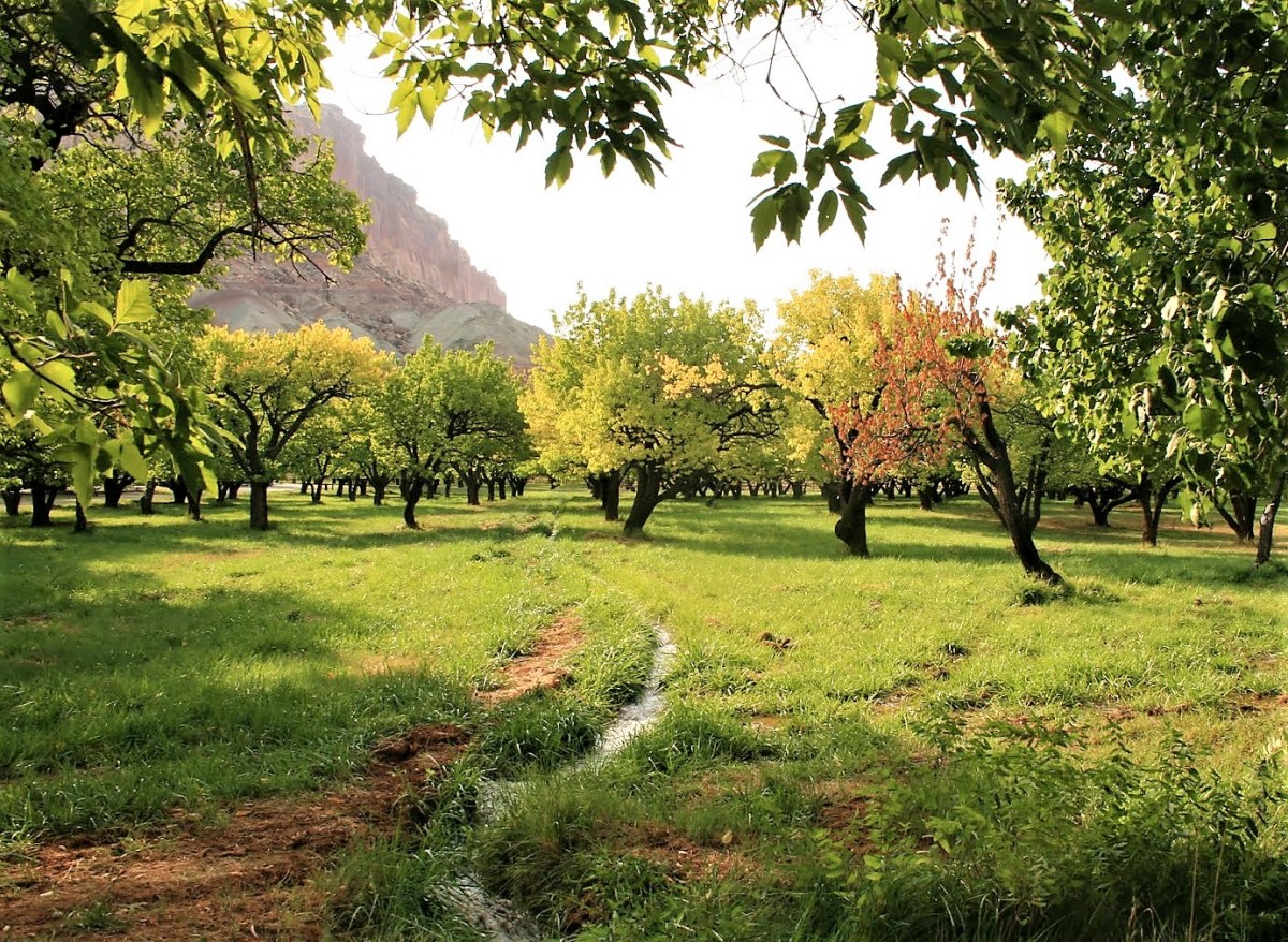
you would have a delicious National Park named Capitol Reef that few would ever taste. And that would be the greatest crime, because this is a four-course park that satisfies all the senses, and requires at least four days to consume all it has to offer.

And yet Capitol Reef stands out as a National Park that’s most in need of a publicist or a brand manager. For a park that has so much to offer, it defies logic that little more than 1 million visited last year. Maybe it’s the name. It’s connotation to Washington–as unpopular as politics are today–might have an impact. Or perhaps the mention of “Reef” confuses visitors who may mistakenly associate a park bordering on Utah’s shoreline. Either way, it’s time to re-imagine a name that befits this jewel.

A big regret when planning our itinerary through Utah was naively categorizing this park as “order-to-go” fare, when it clearly requires a more leisurely approach to appreciate all its hearty features and delicate nuances.

Our two days at Capitol Reef were full and varied. We hiked; we drove; we participated in ranger-led discussions; and we off-roaded. We also got caught in a flash flood just minutes after taking the scenic drive–with all the wash basins turning red from torrential run-off, stranding dozens of cars in the canyon until the rain ran its course.flash flood (2)
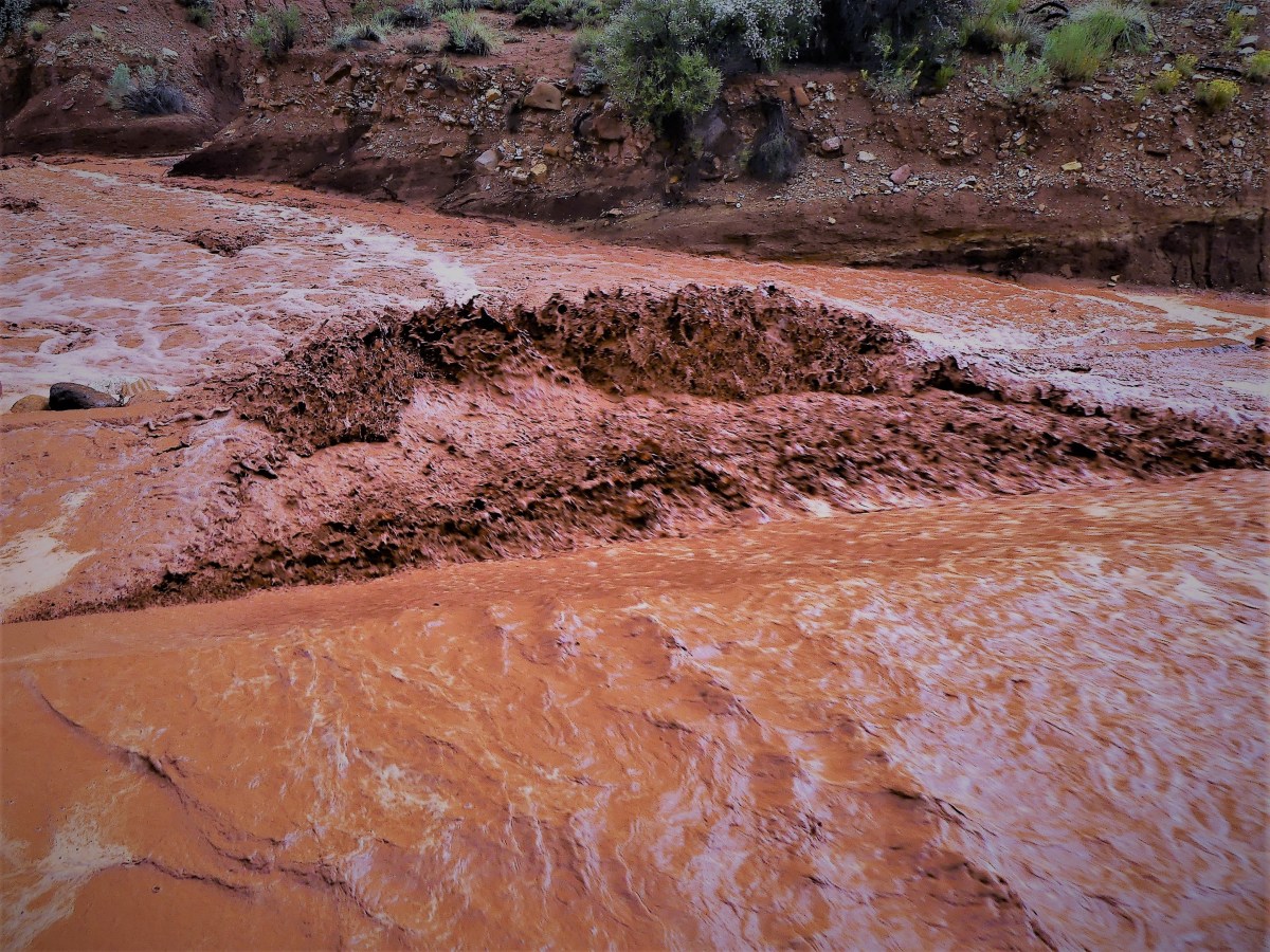
But we would not be detained. The truck’s high clearance and V-8 muscle was more than enough to plow through two feet of fast water, cutting a red swath through the wash, and a sending a bloody spray across my windshield and windows. The benefit of beating the waterfall gave us the road ahead to ourselves, as all the other cars were left behind in our wake.

Conveniently, the rain passed the moment we approached the Capitol Gorge Road,dome drama
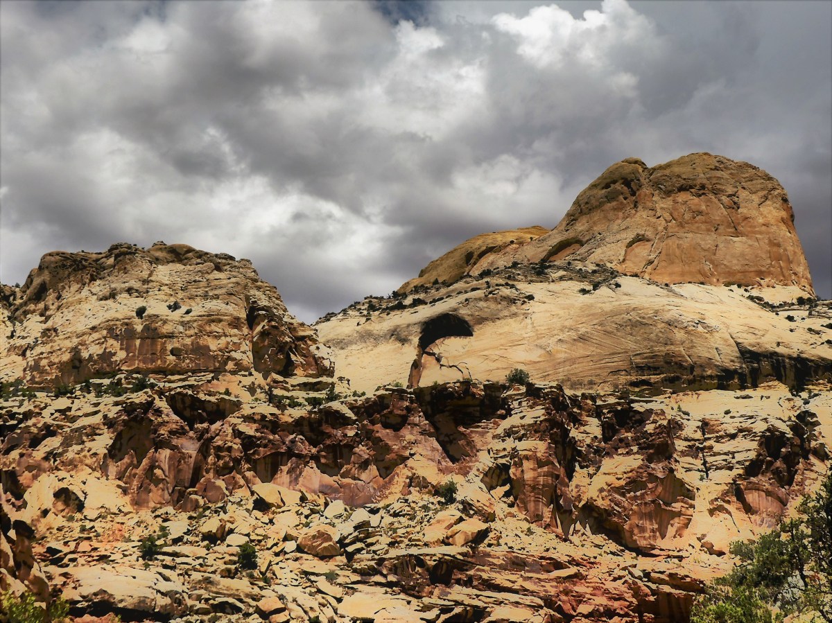
and coincidentally coincided with a Sirius-XM radio broadcast of Trump announcing the American withdrawal from the Paris Climate Accord. It’s hard to relay the irony of negotiating the winding narrow passage between the canyon walls while listening to Trump rationalize his decision under the guise of job losses in front of a partisan Rose Garden rally. With every fractured sentence and every tired hyperbole, the crowd would erupt with enthusiastic applause, acknowledged by Trump’s demure, “Thank you, thank you.”

It seemed sacrilegious, listening to Trump’s politicized and pacified diatribe while zigzagging through the gorge and admiring nature’s wonders. Although the satellite signal would occasionally drift with the drive–interrupting the incongruity of his half-hour address–I was certain that Trump would never be discussing the benefits of tackling climate change, or consider the potential of adding green jobs that promote renewable energy.

The end of the Capitol Gorge Road fed into the Capitol Gorge Trail. Leaving the F-150 behind, we followed the gorge on foot,

Leah hiketracing many generations of footsteps before us.grafitti1 (2)
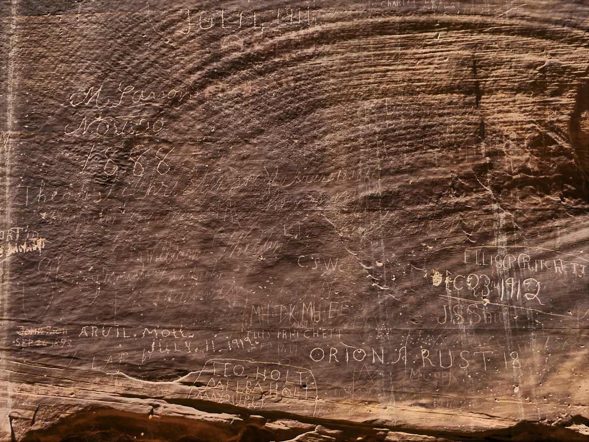
These people left us a great treasure (discounting the grafitti–more on that later) to inspire us, but also assigned us a great responsibility to preserve and protect it so that future generations may also be inspired. Our legacy as moral and ethical humans relies on it. And our future as a planet depends on it.

And that’s when it dawned on me. Take Trumps’ tired mantra, and re-purpose it!

I hereby propose that Capitol Reef now be called “Tremendous National Park”!

What do you think?

* All photos posted are from Capitol Reef National Park. Any similarity to other National Parks is purely intentional.

Hoodoo You Trust?

What a difference a day makes. Leaving Zion behind for Bryce Canyon gave us cooler temperatures, cooler tempers, and cooler views–now that we left the maddening crowd behind and were no longer limited by what we could see (Keeping an Eye on Zion).

After driving two hours through riveting scenery along 89 North, we arrived at a KOA in Cannonville bordering on the edge of nowhere, approximately 20 minutes past the National Park. We dropped the trailer and headed back to the park to get our nature fix. We followed the 18 miles of park road to its conclusion, and walked the Bristlecone Loop Trail, a thousand year-old alpine forest where the remains of a 1600-year-old bristlecone stands watch at the edge of Yovimpa Point,…Bristle Cone Pineoffering panoramic views of the Colorado Plateau going as far back as the Grand Canyon’s North Rim. Clear days at Bryce can offer the longest views anywhere on the planet–beyond 100 miles away, thanks to the amazing clean air quality.

Yav Pointvolcano on the mesa

lookout3

But it was the Rainbow Point lookout around the other side of the ridge that put smiles on our faces and brought the color back to our slack-jawed cheeks, giving us an early preview for the next day’s hike.

Rainbow point

It was our first look at Bryce Canyon’s hoodoos–the world’s largest collection of stone chessmen formed by ice and water erosion–and they were magical.

Working our way back, we stopped at one of many scenic overlooks hugging the road side. Looking over a log rail, seemingly within arm’s reach was a formation called the Natural Bridge, an 85 foot span that is really a natural arch. So why it’s called one thing when it’s really another makes it just a bit confusing. Is it a bridge that’s an arch, or an arch that’s a bridge?  Ask a ranger and you’ll get two different answers. Okay?

better bridge

After pull-overs at Sunset Point and Sunrise Point, we were certain that the next day’s hike should take us deeper into the Amphitheater for a more intimate and detailed experience.

sunset trail panaramasunrise trail

Passing through Tropic, Utah on the way to KOA, we detoured for groceries and a visit to TruValue Hardware to possibly resolve a nagging situation since we left New Jersey: how to adapt a quick connect hose between our Weber Q 2200 LP grill and the Airstream’s LP service port.  While it may appear mundane to the average urbanite, the ability to bypass the LP tank, and connect directly to the trailer makes it a no-brainer and a classic time-saver for RV set-ups.

Thus far, at every newly arrived location, I’m constantly reminded of the additional time required to set up the grill, when I know my time could be better served by drinking a cold beer or replying to reader comments from a blog post.

Whether the weathered attendant behind the check-out counter could help me remained to be seen. I clearly demonstrated to him how the hose to the Airstream port and the fitting coming out from the grill needed a compression union to make the desired connection, and what I got instead was a lecture.

He led me to a wall of grill accessories and told me that what I was looking for was impossible to find, and I was better off buying his $65 kit to connect my grill directly to my tank.

“But I already have that,” I objected. “That’s how I do it now. I’m looking to circumvent the tanks and draw LP directly from the trailer through the quick connection. This part of the hose (I wagged it closer for him to see) feeds directly into the trailer,” I implored.

“So I got fittings around the next aisle over,” admitted Mr. Malcontent, “but I’m not gonna show ’em to ya, and I’m not gonna sell ’em to ya neither.”

“Why not,” I wondered.

“Well, I’m gonna tell ya,” he started, “and you’re probably not gonna like the answer, but those damn Democrats, especially Obama made it impossible for you to do what ya wanna do.”

He paused, waiting for a reaction–maybe to take my political temperature, but I let out a little more rope. “I don’t follow you,” I  reasoned.

“Well, Obama spent eight years in office loading down OSHA with more and more rules and regulations, that you practically need a doctor’s note just to take a shit,” he claimed. “Maybe, you come back when there’s not so many rules.”

Leah arrived in the middle of our transaction holding groceries, and heard part of the exchange. “Let’s go! We gotta get back to refrigerate the milk.”

I left the hardware store in disbelief; it was like a Twilight Zone moment. “How does he stay in business?”

“He doesn’t need your money. Remember, this is Trump country,” she asserted.

All of yesterday was forgotten, when the next day we dropped into the Amphitheater from Sunset Point,a tree
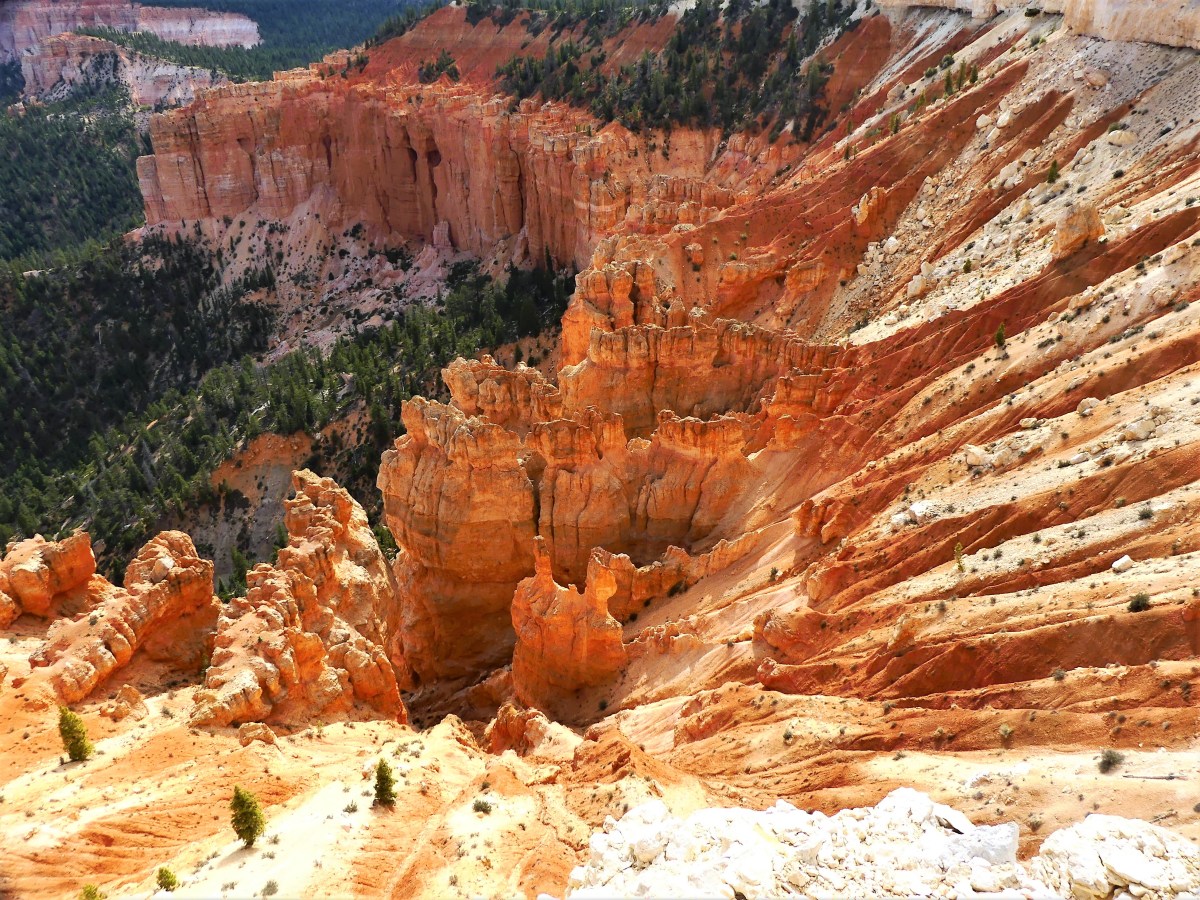
through the Navajo Loop Trail following the steep switchbacks…

Navajo switchbacks
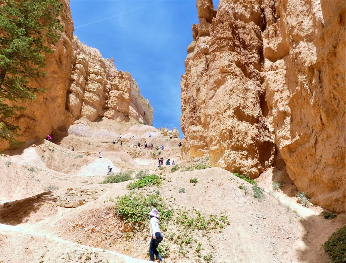
to Wall Street, where enormous Douglas firs have balanced in the rift for over 750 years, like sacred totems,wall street
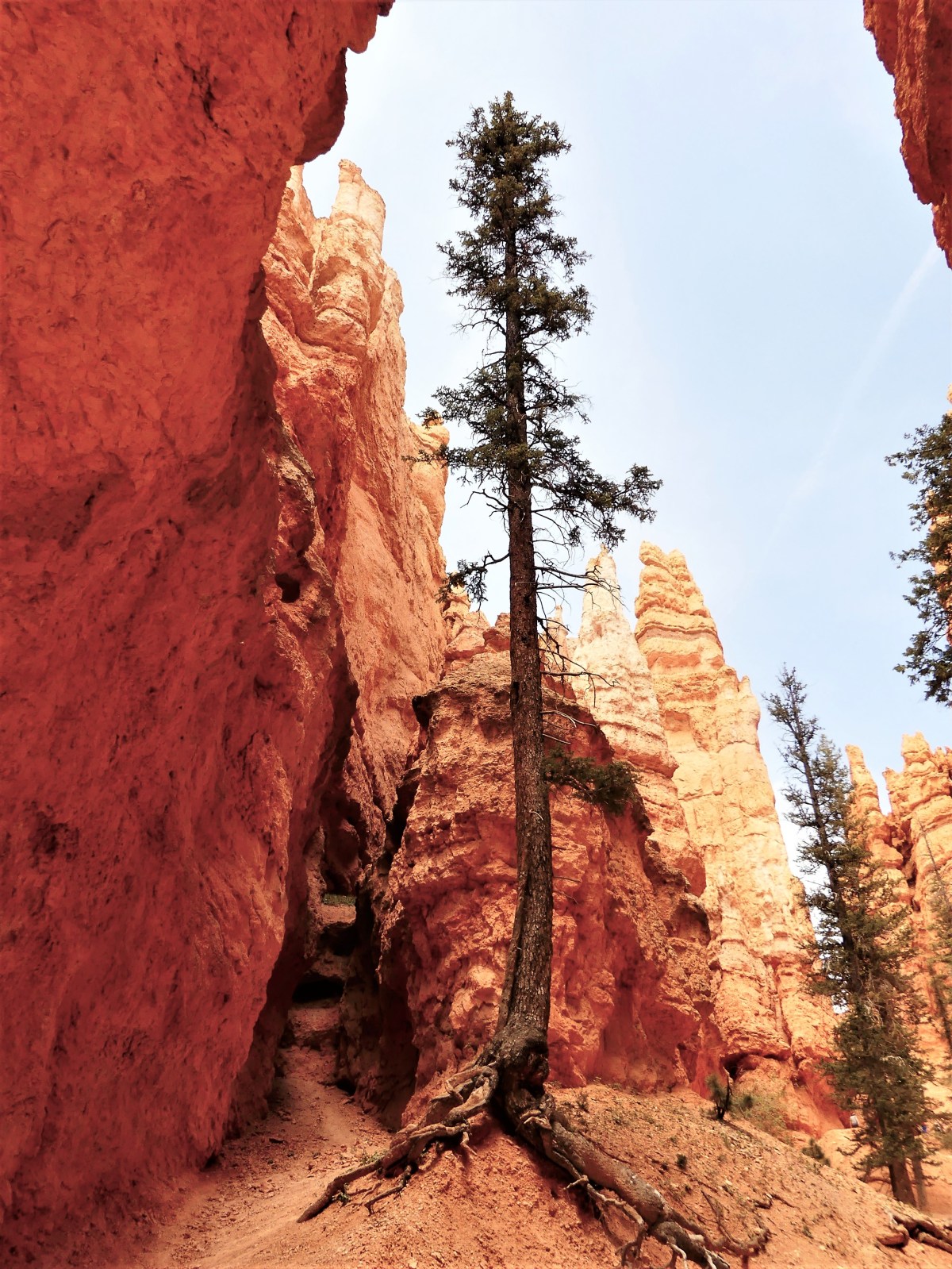
and views of Thor’s Hammer are something to “marvel”.

Thor's hammerBeyond Twin Bridges (another iconic hoodoo formation),

twin bridges 1another series of switchbacks dropped us to the Amphitheater floor. Rather than continue the loop, we opted to cross into Queens Garden, for cake and a spot of iced tea.

Along the way, we met the Queen’s subjects…

subjects
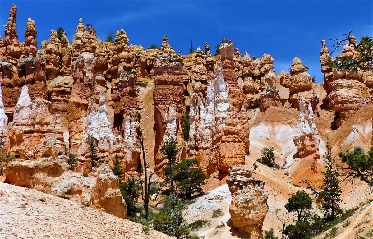
standing along side the Queen’s castle…

castle
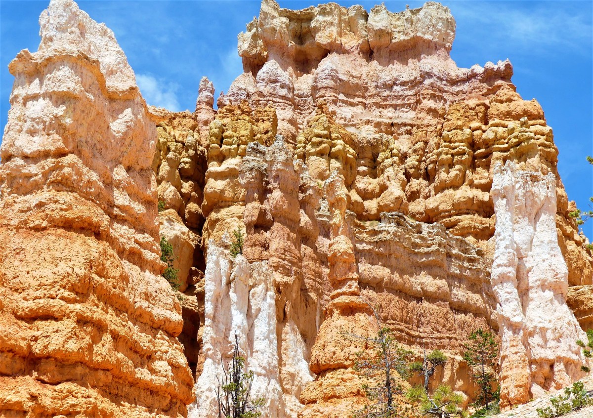
as Queen Victoria looked on high.

Queen VictoriaIt was a “monumental” hike out of the canyon that left us tired, but enthused by the energy surrounding us. Perhaps it was hoodoo voodoo?

all this is mineBut one thing that we both agreed on… we were ravenous after spending time in this imaginary Fairyland world.

raven

But dining out in Cannonville, UT can be a bigger challenge than hiking the Bryce Canyon rim trail. With only two food vendors in a town with a population of 168, we chose i.d.k. BBQ, a food truck with limited acclaim from social media. I don’t know how they got their name, but it was the only game in town, so we thought we’d take a chance.

Originally, Leah was skeptical. “BBQ in Utah?” she doubted. “From a food truck, in the middle of nowhere?… Really!!? Remember, there’s only one toilet in the trailer.”

“Why not?” I countered. “How bad can it be? In a town this size, there must be someone who could cook.

But first we had to find this truck. After cleaning up from a day drenched in fairy dust, we were ready for a night on the town. Boarding the F-150, we literally turned the corner into “town”, and rode four blocks on Kodachrome Drive until we knew it was time to turn around. How could we have missed it?

We turned around to cover our tracks, looking hither and yon for any semblance of a food truck, until we came back to the same turn that carried us into town. Nothing… except the Sinclair station that reminded us that filling up was a good idea before we hit the road tomorrow.

“So what are we gonna do about dinner?” Leah asked.

I shrugged. Standing at the pump, I scanned the horizon, and spotted a flapping BBQ sign just pass the Sinclair stanchion. That’s when I spotted the truck tucked behind the corner motel.

idk bbq (2)Shades of Eat and Get Gas.

We rounded the corner of the truck, only to meet proprietors Emily and Kevin Clark and their four-year-old daughter cleaning up for the day.

“Sorry, we’re outta food,” he lamented.

Maybe it was our fallen faces, or maybe a little hoodoo voodoo, but Emily was soon offering us Kayla’s dinner in a closed container.

“It’s a pulled pork potato,” she proposed.

“What’s that?” Leah wanted to know.

“You’ll like it,” was all she had to say.

“I feel bad about taking your daughter’s dinner,” I responded. “What’s she going to say?”

“Don’t you worry ’bout her,” countered Emily. “She’s been wantin’ pizza anyway.”

After exchanging $20 for a monster baked potato drizzled with cheddar cheese and smothered with a pound of pulled pork, with a side of cole slaw and two warm cups of peach cobbler topped with whipped cream, we drove back to the Airstream for one of the most delightful and serendipitous take-out meals since we pulled out of Jersey.

Trust me.

Keeping an Eye on Zion

The crowds that crammed into Zion National Park over Memorial Day weekend left us frantic and bereft. As our first stop in Utah, we came to Zion to enjoy the trails and distinctive scenery of mountains and water. We planned to hike the Narrows through the Virgin River, and experience the Kolob Arch (the world’s second largest natural free-standing arch), but we never accounted for (and neither did the Park Service) the tens of thousands who would mob the park this particular weekend while we were here.

Staying over in Springdale, just outside the park, gave us easy access to the southern park entrance, only half a mile away. And the convenience of having a free shuttle bus stop outside the RV campground with transfers to trail heads available inside the park, meant we could leave the F-150 behind. Or so we thought…

The one day we had to explore, Sunday, we walked to the bus stop only to find it spilling over with more than fifty people waiting in a discordant line.  According to a bus dispatching authority (a busy body) who had been waiting for over half an hour, “Buses come by every fifteen minutes, but will pass by without stopping if they are full, and so far, two buses filled with standing passengers has already passed.”

When a third bus passed without stopping, Leah and I started for the park gate on foot.

When we beat the shuttle bus to the park entrance due to traffic back-ups at the gate houses, we realized that things were not going according to plan. After checking in with a park ranger at the visitor center, we were directed to the park shuttle buses that would transport us to stop 9. Searching for the end of the line, brought us as far back as the park entrance, where the wait for boarding a shuttle bus would be over two-and-a-half hours!

serpentine

back of line

When asked about the situation, a ranger confessed, “I won’t lie. This park is not equipped to handle these many people. It’s like trying to scoop five pounds of poop into a four pound bag. We’ve never seen it like this before, and I’m embarrassed to say, there’s not too much we can do about it.” Yet the park’s popularity has been steadily evolving, making it surprisingly, the fifth most visited National Park with over 4 million guests last year, just beating out Yellowstone.

The thought of waiting for a bus in direct sun during peak day seemed like a deal breaker. Our planned activities inside the park were scheduled to carry us late into the day, but with bus service being backed up, and the potential of sharing the trail with hundreds if not thousands of hikers, we wondered if the day could still be salvaged.

Another look at the park newspaper revealed a moderate four-mile hike from the visitor center along the Watchman trail with sweeping views of Springdale, and iconic Zion landmarks such as Beehives, Towers of the Virgin, West Temple and the Altar of Sacrifice, ending with a view point of the Watchman, a rocky spire rising to an elevation of 6545 feet. We shrugged and accepted out fate. While not our first choice (and ranked #19 of 49 attractions in the park by Trip Advisor), it would have to satisfy our urge to be a part of the Zion experience.

What most hiking critics reported as a quiet and thinly-populated trail was being exploited today as an overflow option for many other folks with “won’t-wait-in-line-itis”, including several families with small children, small groups of rowdy teens, and an assortment of unprepared novices wearing flip-flops, trudging up occasional steep and narrow switchbacks, and wishing they brought more than a small bottle of water.

Overall, the hike to the top of the ridge line paid off in dramatic and sweeping views from north to south.

zion canyon

1.1

2

Zion range

watchtower

The next day we drove the Zion Canyon Parkway north through a skinny one-mile tunnel cut through Zion rock in the 1930’s, and closed to two-way traffic to accommodate wide rigs like ours.  The switchbacks were hairpin and narrow, but Leah has grown confident in my driving over the past month, and allowed the radio to play with the sun-roof open, while she enjoyed taking iPhone pics of the canyon vista.

rig

sunstreak

Finally, a scenic turn-out featuring Checkerboard Mesa opened along the roadside, allowing me to pull up to a yellow coach (no joke) filled with scores of yammering Chinese dressed in down jackets, white gloves, and colorful umbrellas.

While most cameras focused on the mesa, I was fascinated by the checker-boarding.

black and white1

Checkerboard mesa

P1040086

We’re on our way to Bryce Canyon National Park, where hopefully, the crowds are thinner and the air is fresher.

Petrified

Originally,  the Petrified Forest National Park was intended as a soft layover to break up a six hour drive from Albuquerque, NM to Sedona, AZ, but it quickly became apparent after rounding the first bend of the 28-mile park road, that the vibrant beauty of the painted desert and the pop-color collage of the rainbow forest provided a photographic feast that justified more than a peripheral drive-by. We spent half a day immersed in inspiration.

A “tapestry of time” infuses all the turnouts, loops and trails, dating from: prehistoric remnants of dinosaur fossils, to petroglyphs of Ancestral Americans, to grazing habitats supporting Southwestern settlers, to the crossroads of historic Route 66. Every visitor through the ages has put their visual time-stamp on the landscape, turning our stop-over into a hike through history.

painted desert detail

painted desert
Chinde Point

teepee wide

Teepee
The Teepees
petroglyphs
Hopi calendar? at Newspaper Rock
crow
Raven perched
dinner
Red-tailed hawk picks up a rattler

blue mesa panarama

Blue mesa
Blue Mesa
agate bridge
Agate Bridge

petrified slices

rainbow forest

rainbow log BG
Crystal Forest

red polish

contrast polish
Mineralized wood

What Time Is It?

Camping inside Guadalupe Mountain National Park is notable for the dramatic setting presented to travelers sharing the trail head to Guadalupe Peak, the highest peak in Texas at 8751 feet elevation–fronted by El Capitan, it’s foremost surveyor’s point.

El Capitan

Access to the park is available to limited numbers of tents, trailers and RVs behind the Pine Springs Visitor Center, where the Guadalupe Mountains fan out in a protective panorama. Reservations are unavailable, as it’s first come, first served dry camping that is best described as boondocking in narrowly aligned asphalt stalls, where utility hook-ups and dumping stations are non-existant.

It was a crap shoot, but after a four-hour drive from Marfa, we score one of twenty available RV sites that are quickly filling up around us. An abundance of solar cell arrays dot the parking lot-with thirsty batteries soaking up sun rays needed for later use–while I, in turn, crank up the Honda 2000i generator to attend to our personal energy needs.

Our new neighbor, Mr. and Mrs. Salt and Pepper from the Sunshine State pull up beside us just as I disengage the F-150 from the Airstream, in search of the turn-off from the Guadalupe Pass that services the McKittrick Canyon Trail.

During our late-day hike, our marginal shade is supported by occasional juniper pines and Texas madrone…

Tree of Lifeas we cross several dry river beds…

canyon wallalong the arroyo to Pratt Cabin, a Depression-era structure built entirely of stone.

Pratt Cabin
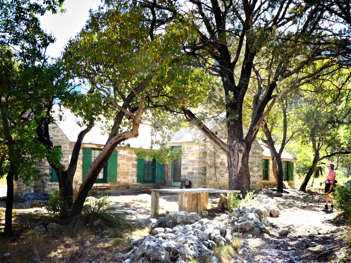
Rocking chairs under a cool porch provide perfect respite from the simmering sun.

porch

Upon returning to the Airstream, we follow parking lot protocol with dinner preparation plans en masse, prompting Mr. S&P to cautiously knock on our screen door.

“Howdy, neighbor,” I announce through the screen with all good intentions. “What’s up?”

Holding back, but clearly annoyed, he addresses me in a veiled voice. “I hope you’re aware of the rules about running your generator,” he reprimands.

Gauging his tone, but uncertain of the point he’s trying to make, I answer, “Okay?”

“So were you planning on turning that thing off anytime soon?” He is more ordering than asking.

“Well, sure,” I try to reassure him, “but it’s only 7:30. I still have half an hour before quiet time.”

“I don’t think so,” he challenges, pointing to his watch.

He’s now flanked by his wife, who’s approached the Airstream to reinforce her husband’s position, and it becomes clear that he’s been put up to the task.

“Did you tell them about the rules?” she intervenes. “Tell them to read the rules by the bathroom.”

“I did, dear. He knows all about it,” her husband relents.

Now looking pointedly at me, she asks, “So why’s that thing still running? It’s 8:30, you know, and you’re out of time.”

“Look,” I start out. “I think you’re mistaken about the time. As I mentioned to your husband, I still have half an hour to go.”

“Not according to my phone,” she insists, waving her iPhone.

Leah joins me at the door to even the playground odds. “Then you must’ve forgotten about the time change,” Leah interjects. “We just crossed the border from Central to Mountain time, and you forgot to turn back your clocks.” Rubbing it in, “Didn’t you get the park memo?” she says smugly.

“Sounds reasonable,” she shrugs. Are you certain?” doubts Mrs. Salt and Pepper.

“You can’t rely on your phone,” Leah tutors her. “For some reason it’s not showing up yet.”

Mrs. S&P nudges her husband, teasing, “I can’t believe you didn’t know that.”

“Shit happens,” I announce, side-stepping the S&P’s on my way down the Airstream stairs. “While time is still on my side, please excuse me while I tend to the chicken on the grill.”

Walking away, Mrs. S&P mutters to her mate, “I feel like such a fucking idiot!” Then, calling out to me, “By the way, that smells sooo goood.”

Returning to their RV box, I overhear Mr. S&P lament, “I told you not to bother them.”

I remain exalted in my vindication. At precisely 8:00 pm, I cut the generator din, restoring tranquility to the campground community where I’m no longer the menace of Guadalupe Mountain.

And I am absolved when the quiet of the thin mountain air carries the collective sigh of my next-door neighbors through their hollow RV wall.

Carlsbadland

If Disney were to design a cave attraction, he couldn’t do any better than Carlsbad Cavern, for deep within the Guadalupe Mountains of southeast New Mexico lies an enchanted forest of mysterious-looking limestone formations.

long ears (2)

The journey begins at the ticket counter, where for the price of admission, a visitor can access the cave from a nearby switchback path, or take a high speed elevator 800 feet down to an exploration crossroads that leads directly to a food concession stand.

elevator

While there are a few adventure hikes below the surface for limited numbers of ardent spelunkers, a majority of the nearly 3,000 visitors a day (on average) are content to follow a one-mile self-guided tour of the Big Room along a narrowly paved walkway, where featured formations are illuminated by hidden spotlights and protected from access by stainless steel handrails.

To the casual observer, the speleothems (e.g. stalactites and stalagmites) look like random thousand-year-old mineral deposits. But to the trained eye, many of the formations–whether disguised within wall recesses…

faces

Groot

or standing straight and tall in plain sight–

Chinese emperor (2)

double as custodial creatures who stand guard by rock castles,

castle on the rock

brocoli

and towers…

double dicks (2)

to protect them against invaders who are so fascinated by their structural beauty, that they must scale their delicate walls.

Like vintage Disney design, the spectacle that is Carlsbad Cavern is overwhelming to the senses. Whether it’s looking up at the lion tails,

lion tail (2)

and the crystal chandelier…

chandelier

or looking at popcorn streams beneath rippled water…

natural stream (2).jpg

…it’s difficult to imagine not being seduced…

shaft (2)

by all the stunning eye candy.

eye candy (2)